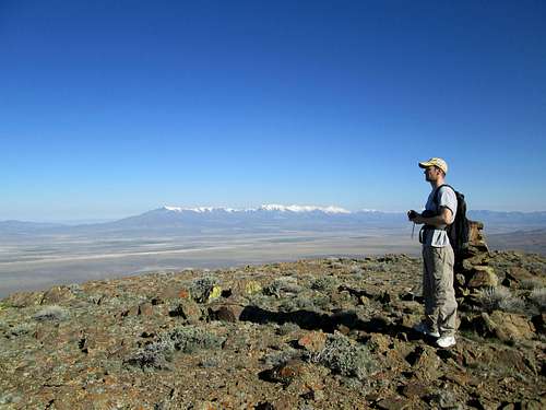
![Looking north]() Brett on Hot Springs summit
Brett on Hot Springs summit
The drive
Brett and I only had 2 days to play with so we figured we'd pack those two days as full as we could with Nevada prominence peaks, hopefully 4 overall. I bailed from work after the morning clinic session at the dental hygiene school where I work with the students and headed north to where Brett works and picked him up from there. From there, we drove for 6 hours to get to a car camping spot 25 miles north of I-80 near the small berg called Golconda. Our goals for the next day was Hot Springs Peak and hopefully, Blue Mountain NW of Winnemucca.
We had picked out peaks that were snow free at this time of the year so that meant under 8000'. The four we had targeted were:
Hot Springs Mountain
Blue Mountain
Eugene Mountain range High Point
Majuba Mountain.
The drive up the Eden valley was on a nice dirt/gravel road and other than for a few head of cattle, we had it all to ourselves. The area was green and beautiful at this time of the year and with Adam Peak towering above us on the east, it added to the beauty of what we found. I found a spot just off the road that was level enough for a tent (for Brett) and we settled in for the night. The temps dropped into the upper 20's before the night was over and I was glad my sleeping bag was supplemented with a down blanket I had put in at the last second. Brett said his feet were cold all night and that had made his night a bit more uncomfortable than mine was.
Hot Springs Mountain range highpoint.
We had read various reports by Brad
Boester, Dennis
Poulin, Caleb
Morris and Ken
Jones on their visits to this mountain so knew what to expect. However, both Brett and I had studied the jeep roads near the mountain and hoped, that if there wasn't any mud to deal with, we might be able to get closer than the others. In the morning, armed with our waypoints and maps, we did indeed find a jeep road that took us closer to the mountain. It required high clearance but was free of mud and I drove it as far as I could before it petered out and disappeared. In fact, the road we found cut both the distance and the elevation gain in half as I was able to park my truck not far from Cherry Springs. Now we figured we should be able to pick up Blue Mountain northwest of Winnemucca later in the day.
Our route from near Cherry Springs went up the hill and then angled toward the peak, a distance of about 1.4 miles with about 1100 feet of elevation gain. My parking spot was (nad 27) 41.2024 117.4325 elev. 5785
On the way down, we did a more direct return to where we parked and that would probably have worked well for the ascent. No matter since the whole distance was not quite 3 miles round trip and less than 1100' of elevation gain. From the summit we had some good views of nearby Adam Mountain and could see there was still a fair amount of snow on its upper reaches. We also noted that Santa Rosa and Granite peaks were still carrying a nice winters load off to the Northwest of our summit stance. A small glass bottle contains a register with the names of the few visitors that visit this remote peak and the register also contains the names of a few others, mainly hunters who seek either chukar or deer in this area.
Our return to my truck went quickly and soon we were retracing the dirt tracks back to the main Eden Valley road and made the drive out to I-80.
A few facts about Hot Springs Range HP: At 6940' feet high, it is a good choice when snow blankets the higher peaks nearby. It barely has enough prominence however to make the 2000' cut off and it is considered a p2k on
Lists of John but an error range peak on peakbagger.com Both use slightly different measures for what they consider the prominence to be.
Summit log - The ones who had have been to the top of this one is a short list:
Gordon MacLeod and Barbara Lilley
John Vitz
Dennis Poulin
Caleb Morris
Brad Boester
Ken Jones
Brett Hathaway and myself
![Hot Springs summit ahead]() Summit over there Summit over there | ![Hot Springs view]() Looking at Blue Mountain Looking at Blue Mountain | ![Star Peak]() Looking south Looking south |
Blue Mountain 7353'
After hitting I-80 again, we drove into Winnemucca and gassed up and had lunch at the Arby's there. Following that brief "pit stop", we made our way to the Jungo road and followed Dennis Poulin's fine directions to Blue Mountain. We weren't able to drive as far as Dennis did but we were satisfied with where we got and the fact that we were about to get our second peak of the day. A very steep section stopped me from going the last .4ths of a mile so we parked at 5250' and made our way from there. From the end of the track that Dennis parked at, we went up the slopes to the right and worked our way up to the saddle, going right at that point and made our way up to the summit, where we found the remains of an old wooden survey tripod and a glass bottle register hidden in the cairn below it.
Taking some time to enjoy the views and note the snow on the mountains around us, we finally made our way back down the way we came and then once again out to the road that would take us back to Winnemucca and some fast food dinner. We did try a road that looked like it might take us to near the Pole canyon road for Eugene but mud stopped us from trying and we took the sure and safer route back the way we came to Winnemucca via the Jungo road.
After our fast food refueling, we made our way down I-80 to the turn off at exit 149 and drove out to the tungsten mine and turned right onto the dirt track that would lead us to Pole canyon the next day. After about a 1/4mile, we found a place where Brett could put up his tent and we settled in to await the arrival of Al Sandorf from the Lake Tahoe area who would join us for the two peaks we had planned for the next day. Al came rolling in about 8:30 and it was fun to see him again and he and Brett got to meet each other for the first time. Lights were out at 10:30 and a warmer night led to better sleep for everyone involved.
Facts about Blue Mountain: A nice summitpost page exists for this mountain and we also found Dennis
Poulin's peakbagger trip report to be of great value. With over 2700 feet of prominence, this mountain comes in as the 81st most prominent one in the state of Nevada. Our route involved about 2100+ feet of elevation gain about less than 4 miles roundtrip. We parked at an elevation of 5250' and at coordinates (nad 27) 40.9732 118.0606
![Blue Mountain]() Blue Mountain Blue Mountain | ![Heading for the top]() Blue Mountain Blue Mountain | ![Summit tripod on Blue Mountain]() Summit tripod Summit tripod |
Eugene Mountain range highpoint - 7582'
In the morning of the second day, all three of us got up and headed up the Pole canyon road to see how far we could drive. The road was in relatively good shape and with Brett doing the navigation, we made our way all the way up to the saddle located near 7000'. There was some snow but none on the road and none to deal with during our hike itself. The morning had started really overcast and we collectively shared a concern about whether it might start raining and on those roads we had gone up, that wasn't something we wanted to think about.
Brett and Al hiked all the way up the road to the radio shack that was atop the hill to the north of where we parked while I elected to find the path that Dennis found on his return down the mountain when he was there and by doing so, i was able to avoid the "ups & downs" of the ridgeline and saved myself a couple hundred feet of elevation gain which my legs really appreciated. The hike was really a nice one and only the last couple hundred feet up to the summit was steep at all. On the summit, we found a cairn with the register bottle tucked inside. We checked out the signatures and the comments and snapped a few pics and made our way back down to our vehicles since we still had Majuba Mountain in our sights and with Brett and I needing to drive all the way back to the Salt Lake City area on the same day, the sooner we got it done, the earlier we could get home. Our drive back down the mountain was uneventful (thank goodness) and all in all, Eugene was probably the easiest peak out of the four that Brett and I did during the two days, of course, mainly thanks to a road that went all the way up to 7000'.
Facts about Eugene: With well over 3300' of prominence, Eugene comes in at the 51st most prominent peak in Nevada. It is a tremendous viewpoint and if you had the time, you could also pick up a small prominence peak known as Eugene Peak (benchmark) that has close to 500' of prominence. I noted on the register found on peakbagger's page for this one that several others had done this one while they were so close to it. Our round trip effort was about 2 1/2 miles with about 700' of elevation gain (for Brett and Al) and less than that for me thanks to the nice path that traversed both of the small hills along the way.
![Top of the Eugene range]() High point of Eugene Mtn range High point of Eugene Mtn range | ![Looking south]() Looking south Looking south | ![Eugene Range Highpoint]() Eugene Mountain range high point Eugene Mountain range high point |
Majuba Mountain - 7388'
After we drove back out to I-80, we made our way to exit 145 and found our way to the key junction that Brett had found that would allow us to get very close to the base of the mountain. Instead of following Dennis's fine route, Brett had spotted a different route that he felt we should try and his route worked like a charm. Had the last section of a road leading up to the very ridge we would be hiking not been in bad shape, we could have driven even higher. Someone with a vehicle with a smaller footprint (like a jeep) might be able to get all the way to the end of the road but as it was, we only had to hike an extra 500 feet of elevation gain which made the overall elevation gain about 1400'. Distance was about 3 miles roundtrip. Kudos to Brett for his studying of google earth. We parked at 6020' and the waypoint was 40.6561 118.5039 (nad 27)
The first half mile was up the deteriorated road to the saddle and then cross country from there to the summit where we found a benchmark and a glass bottle with a register in it. Most of the signatures were of people who often hike prominence peaks around the state of Nevada. The views were exceptional and we had a good look over toward look over towards Granite peak near Gerlach and noted that it still had a good load of snow on it. Since we had to get back on the road and had a long drive back to the Salt Lake City area (at least 7 hours away), we didn't linger long to celebrate the fact that this was Brett's 100th p2k that he'd done since he'd started his prominence peakbagging career. He has already done almost all the ones in Utah and this was his 8th in Nevada. We high fived all around and started down the mountain to our vehicles. From there, Al headed back to South Lake Tahoe and Brett and I headed east. I walked in the door of my home at about 11 pm and just beat a big thunder storm that pounded our area about an hour or so later.
Overall, a great whirlwind of a trip that netted 4 nice summits and a nice chance to spend two quality days with an up and coming peakbagger who is also now hooked on prominence peaks.
Notes about Majuba Mountain: With its prominence exceeding 2467', Majuba is the 103rd most prominent mountain in Nevada. It is located relatively close to I-80 and the dirt roads we had to drive were in good condition. The last section of road is the poorest and requires high clearance and I shifted into 4WD for a couple of spots. If you are able to drive as close as we did, you will be rewarded with an easy and enjoyable hike.
I ran out of space for pics about the time we were doing Majuba.
![Majuba Mountain (NV) Benchmark]() Majuba benchmark
Majuba benchmark
Summit logs - Since 1995 when Gordon MacLeod and Barbara Lilley put the register up there, the following had signed in:
John Vitz
DonnaO
Ken Jones
Dennis Poulin
John Ide
Brad Boester
Ron Moe
and then Al Sandorf, Brett Hathaway and myself.
Not many for almost 20 years.
Comments
No comments posted yet.


 Summit over there
  Looking at Blue Mountain
  Looking south
  Blue Mountain
  Blue Mountain
  Summit tripod
  High point of Eugene Mtn range
  Looking south
  Eugene Mountain range high point