
|
|
Area/Range |
|---|---|
|
|
52.26783°N / 3.20422°W |
|
|
Hiking |
|
|
Spring, Summer, Fall, Winter |
|
|
2165 ft / 660 m |
|
|
Overview:-
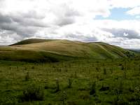
The Radnor Forest is an amazing area but does not get the attention it deserves The Radnor Forest vast open area from the summit trig of Nyth-grug
The Radnor Forest is a diverse part of central Wales consisting of upland and woodland areas of approx 4500acres rising up to a height in excess of 600metres. The forest encompasses many woodland types from upland spruce plantations planted mainly by man on its higher ground to natural Larch, Douglas Fir. Varied Broadleaved trees are in the more sheltered valley sides such as Common Ash, Oak and Sweet Chestnut. When out on the high open and bleak moor land area Bilberry is the most common plant followed by Cotton Grass and Heathers. Many years ago the term forest did not mean a large area planted with trees as many people think of the meaning forest today. The term forest meant it was once a great hunting ground and the forest forms a central high point in the midst of Wales that commands fine views in all directions. Although occupied by trees planted by man on its east and north sides. Most of the forest area still consists of open and bleak countryside.
If you are a keen walker and make a day out of it in the correct weather covering all the main tops these are the summits and places that will be in view.
Starting from in England the county of Shropshire’s finest summits are visible. These are the Stiperstones Ridge, Caer Caradoc, Lawley, The Wrekin, Brown Clee Hill which is the highest point in Shropshire and its neighbour Titterstone Clee Hill. Further on in the east, just between the two Clee Hills the city of Birmingham and its buildings can be easily seen on the clearest of days. Also visible are the Malvern Hills and Bredon Hill in Worcestershire, the Cotswold Hills and Birdlip in Gloucestershire, with the city of Gloucester’s cathedral just visible on the finest of days with May Hill also in Gloucester in the foreground.
  |
Moving on into Wales now and the list is almost endless. The views south to south-west are as follows. Starting with the high ground of The Forest of Dean in the south moving clockwise you can then see the many summits of the Brecon Beacons National Park. These are from the vast Black Mountains range in the National Parks east, the full Brecon Beacons range, Fan Fawr, Fan Lilla, Fan Nedd and Fan Gyhirych, then the complete Black Mountain range is visible in the National Parks west. The views south-west to the west are as follows. From the south-west of Wales right up the west is the Cambrian Mountains dominated by Plynlimon Fawr in the west. The views north-west to the north are as follows. In the north-west to the north the summits of Cadair Idris, The Arans, most of the big Snowdonia summits, Arenig Fawr, The Berwyns and Corndon Hill are all visible then from Corndon Hill we come back across to the Stiperstones Ridge in Shropshire.
 |
A lot of the highest hills and famous viewpoints across our country that command views like this normally have a viewing pillar giving references, direction and distance to what you can see. I guess because the Radnor Forest summits are so quiet and rarely trodden they obviously have no reason to put one up here.
The Summits and Tops:-
 Great Rhos 660m
 Black Mixen 650m
 Bache Hill 610m
GREAT RHOS 660m
Great Rhos Streetmap Link – SO 1790 6390 Lat/Long 52.267828/-3.204219
Great Rhos is the highest of the summits within the Radnor Forest and at 660 metres with its trig point has the status of a UK Marilyn (more details on Marilyn summits via this link). It stands on a vast bleak area of open moor land on the western side of the Radnor Forest and commands some fine views across the south, west and north regions of Wales. There are many of the primary Welsh summits visible from this view point. The summits of the Black Mixen and Bache Hill block most of the eastern views.
 The trig point on the bleak open summit of Great Rhos
 View North
 View East
 View South
 View West
BLACK MIXEN 650m
Black Mixen Streetmap Link – SO 1950 6450 Lat/Long 52.272736/-3.181196
At 650 metres the Black Mixen carries an ancient sepulchral mound surmounted by a trig point. Near to the summit trig it is crowned by a 60 metre high radio communications tower that belongs to the Powys and Dyfed Police Authority. The radio tower is a landmark for many miles and can be seen from most of the high hills throughout the Midlands region from the east, throughout Wales from the west and can also be seen from as far across as the Cotswolds above Gloucester at the Birdlip Viewpoint which is over 60 miles away…! Although this is not the highest of the Radnor Forest summits the Black Mixen does from my point of view offer the most rewarding views. The only part blocked from view here is the western Cambrian Mountains and Plynlimon Fawr by the bleak open area of Great Rhos.
 The trig point on the summit of Black Mixen
 View North
 View East
 View South
 View West
BACHE HILL 610m
Bache Hill Streetmap Link – SO 2130 6360 Lat/Long 52.264965/-3.153294
At 610 metres Bache Hill like Black Mixen carries an ancient sepulchral mound surmounted by a trig point. Bache Hill is on the east of the Radnor Forest near the small town of New Radnor. The summit of Bache Hill commands fine views across the east into England, the south-east and south across Wales. The Whimble and Great Rhos block the western views when the Black Mixen blocks the northern views.
 The trig point on the summit of Bache Hill
 View North
 View East
 View South
 View West
 Nyth-grug 538m
 Whimble 599m
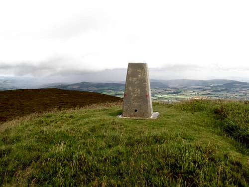
NYTH-GRUG 538m
Nyth-grug Streetmap Link – SO 1700 6060 Lat/Long 52.238126/-3.216156
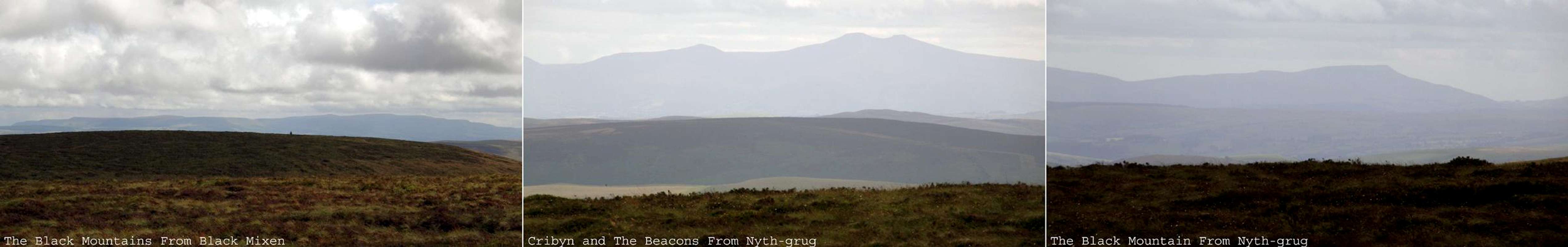
At 538metres this is a small isolated summit on the south-west reaches and is surmounted by a trig point. The summit commands fine views in a south-east, south and south-west direction. The southern views cover the full summits of the Brecon Beacons National Park from the Black Mountains range in the eastern reaches. The Beacons range in the south and the Black Mountain range in the western reaches. Great Rhos, the Black Mixen and the eastern reaches all block the other viewing directions due to there height.
 The trig point on the summit of Nyth-grug
 View North
 View East
 View South
 View West
WHIMBLE 599m
Whimble Streetmap Link – SO 2050 6250 Lat/Long 52.254905/-3.166071
At 599 metres this isolated summit carries an ancient sepulchral mound surmounted by a modern cairn. This is an easily accessed summit from the local village of New Radnor which it overshadows in the shape of a cone. The Whimble commands fine views across the east, south-east, south and south-west. The Whimble also commands the finest views up through the military occupied Harley Valley.
 Whimble seen from the track to Water-break-its-neck Waterfall New Radnor
Getting There:-
 Section of streetmap with 1:50 000 from OS-Landranger #148
Getting here to the midst of Wales is not the easiest of places to find.
Being a person who has travelled all over the UK, for me it is not a problem, even without a map or sat-navigator.
Well there is one main road to aim for heading from the east or the west.
This road is the primary route A44 London all the way to Aberystwyth and vice-verse. This A44 road is accessed from many other roads that cross it from north south.
The A44 links with the M5 motorway at J7 Worcester. The M5 is the main motorway from Birmingham in the Midlands with the M6 from the north to the city Exeter in the south west.
The A44 links with the A49 at Leominster. The A49 is a main primary road from Warrington in the north to Ross On Wye in the south.
If you join the A44 from either the M5 or the A49 you head in a west direction.
The A44 links with the A470 or the road I call the backbone of Wales at the small town of Rhayader. This road runs from Conwy in the north of Wales, right down through the central region and on down to Cardiff in the south.
If you join the A44 from the A470 you head in an east direction.
All these roads I have commented on are on a north south direction. They link with many other roads that run like the A44 in an east west direction.
As mentioned at the beginning it is not easy to explain so I hope you understand.
If you don’t understand to try and make things that bit easier I have included an embedded google earth map for New Radnor which has a link – get directions from here to here. Click on this and go.
The village of New Radnor and the southern side of the Radnor Forest give the easiest access to the summits. The main area of forestry trees and tracks is on the eastern side.
View Larger Map New Radnor
The Ordnance Survey maps for this area are as follows:-
Landranger Map 148 - Presteigne & Hay on Wye / Llanandras a'r Gelli Gandryll.
Explorer Map 201 - Knighton & Presteigne / Tref-y-clawdd a Llanandras
Explorer Map 200 - Llandrindod Wells & Elan Valley / Llandrindod a Dyffryn Elan
Ordnance Survey Website
Access to the summits and tops:-
 The police radio tower on the summit of Black Mixen
There are various routes you can do on these summits.
You can if you wish do the eastern reaches in one day such as Bache Hill on an easy and enjoyable route up via The Whimble from New Radnor. After Bache Hill you then follow the forest track on to the Black Mixen with its radio tower.
Then you can do a separate route for the western reaches starting from the Water-break-its-neck waterfall car park. From here you can head up the valley of Black Brook and out on to the Great Rhos then head down the west side and up on to Nyth-grug. This route before ascending Nyth-grug takes you passed a lovely little hanging valley with lots of waterfalls in it. After Nyth-grug you then head back down via the farm and back to the Water-break-its-neck car park.
And of course if you are really keen you can do a complete circle. Take the first route from New Radnor up onto the Black Mixen. From the Black Mixen follow the forest round the northern reaches of the Harley Valley and out onto the open moor land of Great Rhos. Then head down from the Great Rhos as described in the second route via Nyth-grug. After you have got back down to the Water-break-its-neck waterfall the only nasty bit is when you have to follow the A44 road back into the village of New Radnor. This A44 road can have some crazy and fast drivers on it so beware.
When out on these summits on a nice sunny day getting lost should not be an issue but good navigational skills are needed especially if the fog and cloud comes down. The tracks that run through the forest are also easy in bad weather to get lost in. Plan your route with care...!
ACCESS AND RED TAPE
The farmers control alot of access on the lower levels of farm land so stick to the dedicated bridleways and paths but when out on the open summits and in the land that belongs to the Forestry Commission the free to rome rules apply...!
The signs to look for concerning open access are as follows:-
Open Access Land Left - Non Open Access Right
 |
 |
Secret valleys - Waterfalls and Nature:-
Harley Valley Harley Valley
Deep into the heart of the hills is the Harley Valley. This deep valley cuts into the hills from the main A44 road just west of New Radnor and the valley cuts about 5km and its corrie called Harley Dingle is deep between the summits of the Black Mixen and Great Rhos. This valley is used for ammunition and fire arms training. When firing is in progress red flags are flown on all approaches and access to that part of the valley, encircled with danger signs, is prohibited. I heard from my recent walk that this fine valley is now shut off completely too all people and that is a shame because from what I saw when out on the high ground it looks very impressive. I have never walked up the Harley valley and it now looks like I never will…! Oh well.


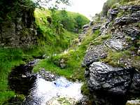
Water-break-its-neck Waterfall
 Water-break-its-neck waterfall near New Radnor
Also of interest is a local waterfall hidden in a small hanging valley. This waterfall has the interesting name of Water-break-its-neck. This waterfall is easily accessed from a public car park on the main A44 road just west of New Radnor village. It is only a short walk up a farm track till you reach a bridge over a stream on your left. Follow this stream up a secluded hanging valley and the waterfall is there at the end tumbling down a rocky face about 60feet high. There has been an official wooden walk way installed along side the stream up to the waterfall. Many years ago you needed your Wellington boots on to paddle up through the stream or walk tight to the edge which gave a risk of twisting your ankle on the loose rocks and tree trunks. The waterfall here supports a lot of wildlife from birds, fungus, trees, mosses and ferns. In the summer months because the air is filled with spray and humidity from the waterfall it is like a tropical rain forest with many different colours of green from the trees, mosses and ferns that grow here.
Mithil Brook
 The secret rocky valley of Mithil Brook
 Mithil Brook
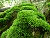
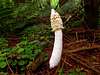
When I was out on the summits and walking through the forestry and waterfalls the mushrooms, fungus, mosses and ferns that were present was unbelievable. Here are some pictures of the mushrooms and ferns.
 |
 |
 |
 |
 |
 |
 |
 |
 |
 |
Accomodation and Camping:-
I am not sure about the camping rules within the area of the Radnor Forest. I guess camping wild out on its summits is ok but you are best to check with the local authorities.Tourist information for Powys:-
4tourists.co.uk/Powys
Local towns for the bed and breakfast services are as follows.
Leominster:-
Bed and Breakfasts Leominster
Knighton:-
Bed and Breakfast Knighton and surrounding area
There are lots of local Bed and Breakfasts in the above google business link.
Powys YHA:-
Powys YHA information
Useful Links:-
Countryside access map - Countryside council for Wales (CCW):-countryside access map provided by the Countryside Council for Wales (CCW)
Powys - County Council
www.powys.gov.uk/
Forestry Commission - Radnor Forest
www.forestry.gov.uk
Powys - Tourist Information
www.tourism.powys.gov.uk
Streetmap
www.streetmap.co.uk