
|
|
Mountain/Rock |
|---|---|
|
|
50.20056°N / 119.29399°W |
|
|
Canada |
|
|
Hiking, Trad Climbing |
|
|
Spring, Summer, Fall, Winter |
|
|
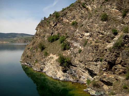
Rattlesnake Point
Rattlesnake Point is a dramatic arm that creates the northern end of Cosens Bay in Kalamaka Lake. The point can be reached by all trailheads in the park by following signs posted at every junction. The average round trip to the point is 6km on varied hilly terrain. The trail can be looped to return via Kalamaka Lake shore.
Hiking
The recommended route to Rattlesnake point starts at the Red Gate parking. Follow the Corral Trail until a signed junction with the Grasslands Trail. Follow the Grasslands trail, it descends in to a pine forest opening up at a signed trail junction for the Pet Beach and Crest Trail. Follow the Crest Trail up and down rocky hills as views start to open up and Rattlesnake Point comes in to view. You will reach an opening at the base of the cliffs on the point. Descend to reach the diving and climbing area or proceed to the top of Rattlesnake Point. Once on the highest point retrace your steps to the Red Gate parking or follow the obvious trail leading to the shoreline. The shoreline trail will take you to Juniper Beach and Jade Bay. Both areas are popular for swimming and may want to be avoided on busy weekends. The shoreline trail will eventually lead back to the lower Twin Bay parking. Twin Bay parking is a hub for the shoreline and interior trails. The hub provides trail signs and a large topo of Kal Lake. Follow the grasslands trail back to the Corral trail and the Red Gate parking. Following the Crest and Shoreline trail makes for a very scenic loop.

Climbing and Diving
The 100+ ft cliffs are a common cliff diving and climbing area. Most climbers will boulder or climb to the height where they can drop in the water when falling.
Risks
Many deaths have occurred on the cliffs of attlesnake Point. BC Parks has posted a disclaimer warning of possible death at the base of cliffs. The point averages a death every 1-2 years. As the name indicates there are many rattlesnakes that bask on the outcrops so caution should be taken.
Getting There
Rattlesnake Point can be accessed by Twin Bay or the Red Gate parking areas. Both areas are accessed following the same road. Kidson Road takes you right along the park and past the Red Gate and parking area (parking for 6-10 cars). Take highway 97 to the Vernon city center and heat east on highway 6. Highway 6 will take you to a sign marked Kalamaka Lake road. Follow this road along the shoreline and turn right onto Kidson. You can start at either the above mentioned gate or continue to the Twin Bay parking.