
-
 20746 Hits
-
 84.82% Score
-
 19 Votes
|
|
Mountain/Rock |
|---|---|
|
|
34.68770°N / 94.5602°W |
|
|
LeFlore |
|
|
Spring, Summer, Fall, Winter |
|
|
2666 ft / 813 m |
|
|
Overview
Rich Mountain is a long, bow-shaped mountain stretching approximately 25 miles from Oklahoma into Arkansas. Part of the east-west trending Ouachita Mountains, the true summit of this peak (in Arkansas) is actually the highest point in Ouachita National Forest. Most visitors to the area pass by on the Talimena Scenic Drive, which connects Talihina, OK and Mena, AR. The scenic byway was constructed based on the Blue Ridge Parkway system on the east coast. When driving along the tight curves or stopping at the various turn-outs, it is very easy to believe that you're a thousand miles east in the mountiains of North Carolina.A very note-worthy feature of this sub-peak is in the fact that Rich Mountain (OK) is this highest point in Oklahoma outside of the panhandle. Back in the days of the Oklahoma Territory and Indian Territory, there was a failed proposal to create a state named Sequoyah in what is today Eastern Oklahoma. If this measure had been successful, this rarely visited area would actually be one of the state highpoints.
If you'd like to view the Rich Mountain (AR) page, which is home to the actual summit of the mountain at 2,681' (817 m), please follow this link.

Geology
The Ouachita Mountains were formed when a collision of two prehistoric continents squeezed up from the ocean floor thick layers of sedimentary rock. They have lost thousands of feet of elevation to weathering and erosion since emerging above sea level some 286 million years ago -- 40 million years before the first dinosaurs walked the earth -- and their tallest summit now reaches less than 2,700 feet. The ancient Ouachitas now appear as the Rocky Mountains might well look 300,000 millennia from now.Information courtesy of the Talimena Scenic Drive Association.
The (Almost) State of Sequoyah

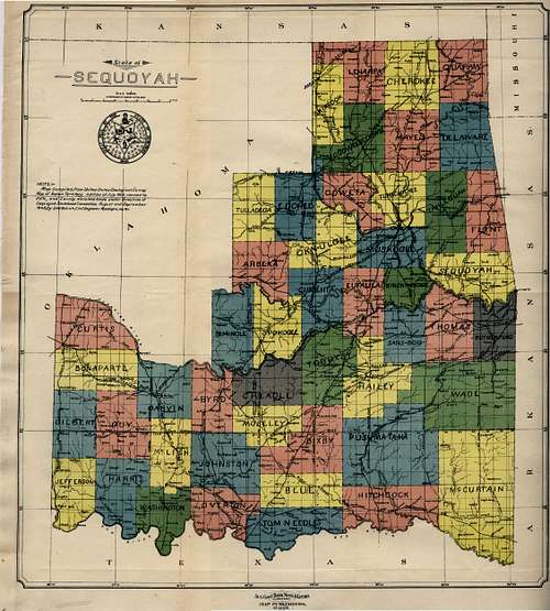
In the early 20th Century, the State of Oklahoma had not yet come into being, with only the western Oklahoma Territory and eastern Indian Territory hinting at the shape of the future Sooner State. In 1902 residents of the I.T., who in large part were composed of the "Five Civilized Tribes," met in the town of Eufaula to discuss a petition for statehood. By August of 1905, the convention had grown to the point of electing leaders from each of the five tribes (Cherokee, Chickasaw, Choctaw, Creek & Seminole) to represent the effort as it was taken to Congress.
The name of Sequoyah was selected for the proposed state in honor of a prestigious Native American of the same name, who was part of the Cherokee Nation. Among his other accomplishments, Sequoyah is probably most noted for his development of the Cherokee written language.
The Sequoyah Consitutional Convention met with significant resistance in Washington, mainly presented delegates hailing from the Eastern states who feared the possible creation of two Western states, Sequoyah & Oklahoma, which could tip the balance of congressional power toward the setting sun. This faction ultimately prevailed upon U.S. President, Theodore Roosevelt, who declared that the Indian Territory could only gain statehood as part of a combined bid with the Oklahoma Territory.
Two years later, the combined efforts of both territories met success through the establishment of the State of Oklahoma on 16 November 1907.
In case you're asking why this free history lesson has been included on a SP page, I would say that if the bid for the admission of the State of Sequoyah had been successful, one of the six bumps that vie for status as the Oklahoma summit of Rich Mountain would actually be the highest point in this would-be-state. Plus, history is fun!!
Getting There / The Six Summits


Getting to the Oklahoma summit of Rich Mountain is a time consuming affair. Although it is quite accessible off of the Talimena Scenic Drive, there are actually six areas in a four mile radius that vie for being ranked as the true Oklahoma summit.
- From the intersection of US-259 and OK-1:
- Drive about 5.7 mi east on OK-1 to a left turn leading to an FAA radar facility behind a gated road. There are two potential areas here that are due north of Quentin Peak.
- Point 2,666' - Point 1 has been surveyed as a spot elevation and is marked by a rock pile about 750ft west of the radar facility.
- Point 2,660'+ - Point 2 is behind a fence and officially off-limits to the public.
- Point 2,666' - Point 1 has been surveyed as a spot elevation and is marked by a rock pile about 750ft west of the radar facility.
- Continue for another 3.0 mi east on OK-1 to a spot on the scenic drive NNE of Wilton Mountain. You'll be about a quarter mile west of a scenic overlook with ample parking (the scenic overlook is 3.1 mi past the radar road turnoff).
- Point 2,660'+ - Point 3 is the western of two spots in the immediate vicinity. The best idea is to just traverse the rocky ridge for about 100 yards to ensure you've hit the highest parts.
- Point 2,660'+ - Point 4 is the eastern of two potential summits north of Wilton Mountain.
- Point 2,660'+ - Point 3 is the western of two spots in the immediate vicinity. The best idea is to just traverse the rocky ridge for about 100 yards to ensure you've hit the highest parts.
- Drive another 5.2 mi east on OK-1 (from the scenic turn-out near areas 3 & 4). You'll be quite close to the Arkansas state line by this point.
- Point 2,660'+ - Point 5 is so close to its eastern neighbor that you'll only have to traverse about 50 feet of ridge to cover both of them.
- Point 2,660'+ - Point 6 is very close to Point 5; see description above.
- Point 2,660'+ - Point 5 is so close to its eastern neighbor that you'll only have to traverse about 50 feet of ridge to cover both of them.
Red Tape
The Talimena Scenic Drive is open year-round, weather permitting, completely free of cost. While planning a visit, be sure to check with the Ouachita National Forest website to get the most up-to-date information.Camping
Camping is available throughout Ouachita National Forest. For information on current conditions and rates, please visit the Forest Service website.- The closest maintained campgrounds are:
- Billy Creek Recreation Area
- Cedar Lake Recreation Area
- Queen Wilhelmina State Park
- Winding Stair Campground
This trail crosses high ridges and valleys, with elevations ranging from 600 to 2,600 feet. It wanders through forests composed of pine as well as hardwoods, including oaks. The Ouachita Mountains follow an east-west path; hardwoods cover the moist northern slopes, while pines forest the southern slopes.
Blue vertical rectangles mark the main trail. White blazes mark most spur and side trails.
Information courtesy of the >Talimena Scenic Drive Association.
The Ouachita Trail
Beginning at Pinnacle Mountain State Park, 15 miles west of Little Rock, the Ouachita Trail runs 225 miles through the Ouachita National Forest, a 1.6-million-acre preserve in central and western Arkansas, to Talimena State Park near Talihina, OK.The trail passes by several of the potential Oklahoma summits.
This trail crosses high ridges and valleys, with elevations ranging from 600 to 2,600 feet. It wanders through forests composed of pine as well as hardwoods, including oaks. The Ouachita Mountains follow an east-west path; hardwoods cover the moist northern slopes, while pines forest the southern slopes.
Blue vertical rectangles mark the main trail. White blazes mark most spur and side trails.
Information courtesy of the Talimena Scenic Drive Association.