|
|
Route |
|---|---|
|
|
40.74330°N / 110.6925°W |
|
|
Hiking, Mountaineering, Scrambling |
|
|
Summer, Fall |
|
|
A few days |
|
|
Class 3 |
|
|
Class 3 |
|
|
Overview
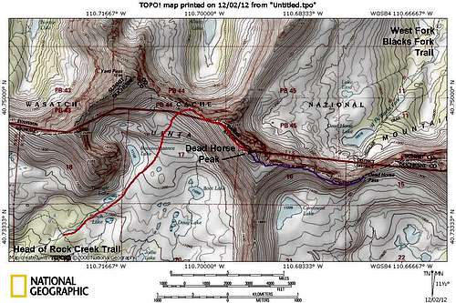
This is the easiest route up Dead Horse Peak, but it is much longer than the route from West Fork Blacks Fork and is a 3-4 day trip. This route follows the Highline Trail to Rocky Sea Pass, goes over the pass and to the basin containing Boot Lake and Reconnaissance Lake before climbing to the summit.The peak is not as rugged from this side, but the area is still full of beautiful peaks, lakes and meadows and is very scenic.
A variation of this route is to come up Rock Creek from Stillwater Reservoir, but that route isn’t quite as scenic and is a bit longer. The basin to the southeast of Dead Horse Peak (containing Continent Lake) could also be used and although longer, might be the easiest route on the mountain.
Getting There
The best trailhead for the hike is the Highline Trailhead located along State Highway 150 33.2 miles east and north of Kamas, or you could drive south from Evanston. You could also start at Mirror Lake, but you must pay to park there, and there isn't as much room to park.Route Description
From the trailhead at 10,347 feet, follow the Highline Trail .8 miles to the junction with the Mirror Lake Trail. The trail continues south and east and drops to 9900 feet. Scudder Lake is passed after 2.2 miles (from the trailhead). After another .8 miles, pass a junction with the Wilder Lake Trail. Stay left on the Highline Trail. After another 1.3 miles, stay right at the junction where the Naturalist Basin Trail branches left.Continue on the Highline Trail towards Rocky Sea Pass, passing the junctions with the Pinto Lake Trail after 1.5 miles and the 4-Lakes Basin Trail after another 1.2 miles. Rocky Sea Pass is another 1.2 miles along a steady uphill grade. The pass is 8.2 miles from the trailhead. Enjoy the spectacular views.
Continue east and down the steep east side of the pass for 1.9 miles to a junction.
There is a choice of routes to be taken from here. The route continuing straight/right along the Highline Trail might be the easiest, but the left route and the Head of Rock Creek Trail is the most scenic and passes many beautiful lakes.
For the purpose of this page I will describe the route passing Lightning Lake since it is more scenic than the Highline Trail (plus Lightning Lake is one of my favorite lakes), but not as long as following the entire Head of Rock Creek Trail.
So, from the junction mentioned earlier, leave the Highline Trail here, turning left on the head of Rock Creek Trail. After another mile, take a right at the junction with the Lightning Lake Trail. The lake is another mile beyond. This trail isn't shown on the topo map, but is in good condition. There are two other forks, and take a left at each one. Along the way you will jump a deep, but narrow and small fish filled stream before the trail climbs to Lightning Lake which makes a good basecamp to explore the area and climb the nearby peaks (the best campsite is on the south side of the lake). A nice waterfall is not too far east of the lake. There are actually many, many lakes in the area and you can always find a fairly large lake to have all to yourself and all are filled with trout as well.
From the north end of Lightning Lake, follow the Head of Rock Creek Trail east and past Helen Lake. Stay on the Head of Rock Creek Trail as it continues east. Notice a ridge and subpeaks jutting out to the south east of Priord/Ostler Pass. One the topo map these are labeled 12,486 and 12,385.
When the Head of Rock Creek Trail begins to curve south, find the creek draining Triangle Lake and follow it up towards the base of Point 12,385. Stay more or less along the creek to the beautiful and very alpine Reconnaissance Lake.
From Reconnaissance Lake, your goal is more or less the low point between Yard and Dead Horse Peaks. Aim towards the ridge, hopefully hitting it just southeast of the low point. The route is fairly steep, but also fairly easy as routes to the peaks in this area go. Once on the ridge, you more or less follow it to the summit and there are no major problems.
Enjoy the spectacular views from the summit. The ridge east of the summit can be descended making a beautiful tour de force of Dead Horse Peak.
Plan on a 3-4 day trip; more if you climb other peaks in the area.
 Upper Rock Creek from the summit of Deadhorse Peak. Explorer and Squaw Peaks, in the background are higher, but less rugged than Dead Horse Peak.

