
-
 10281 Hits
-
 81.18% Score
-
 13 Votes
|
|
Mountain/Rock |
|---|---|
|
|
47.07649°N / 112.35393°W |
|
|
Lewis and Clark |
|
|
Hiking |
|
|
Spring, Summer, Fall, Winter |
|
|
7047 ft / 2148 m |
|
|
Overview
Rogers Peak is an unassuming high point along Montana's section of the Continental Divide which nevertheless offers fine summit views reached from a mostly pleasant stroll. The peak is also attractive as it's easy to reach; for travelers driving between Great Falls and Missoula, a round-trip climb of the peak can be made in a few hours, providing an interesting diversion from the drive and offering outstanding views of much of west-central Montana's wild terrain.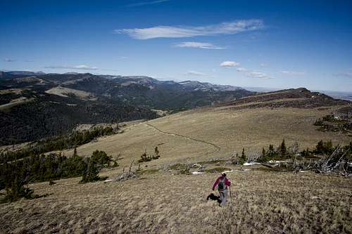
Descending Rogers Peak
The peak and pass are named for Albert Bowman Rogers, a surveyor for the Great Northern Railroad, which considered the route through Rogers Pass before choosing to build its line along Marias Pass more than 100 miles to the north. Meriwether Lewis' detachment of the Corps of Discovery crossed the divide just a few miles north of here in 1806 at what is now aptly called Lewis and Clark Pass. Today, Rogers Pass is the quickest route through the mountains between Great Falls and Missoula.
The peak overlooks a stretch of the 3,100-mile long Continental Divide Trail, a through-hiker's path running from the Mexican to Canadian borders along the crest of the Rocky Mountains, and it's possible to encounter hikers trudging northward late in the season as they approach their final challenges—the massive Scapegoat-Bob Marshall-Great Bear wilderness complex and the rugged terrain of Glacier National Park.
The area holds another interesting distinction. Just south of the peak lies the site of the coldest temperature ever recorded in the lower 48 states. At an official weather station located at the 4K's Mine on January 20, 1954, a staggeringly cold temperature of −70 °F (−57 °C) was recorded. The observer, H. M. Kleinschmidt, had been awakened during the night by the popping sounds of his cabin's timbers in the extreme cold, and noted that the weather station's thermometer had actually stopped functioning because its minimum cold reading had been surpassed—meaning the actual temperature may have been even colder than the official record.
Getting There
The trailhead for Rogers Peak is located on the south side of Rogers Pass on Highway 200. Drive west from the Great Falls area or east from the direction of Missoula and Lincoln on Highway 200 and park at the pullout at Rogers Pass, next to the wooden sign and stairs.What You'll See
From the summit of Rogers Peak, you'll be rewarded with remarkable views of the central portion of Montana's Rocky Mountains, as well as a stretch of the Great Plains to the east. Most notably, to the north and west the southernmost reaches of the Scapegoat-Bob Marshall-Great Bear wilderness complex will be just on the horizon, with the ruddy massif of Red Mountain dominating the view. Red Mountain holds the distinction of being the highest point in that huge area of roadless, primitive land. A bit closer, the timbered ridge of Stonewall Mountain can be seen to the left of Red Mountain, and through binoculars the fire lookout atop it can be made out. Looking northeast, the Rockies give way to the Great Plains, and several of the distinctive peaks of the Rocky Mountain Front appear, including Rocky Mountain Peak and Ear Mountain.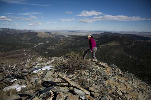
Rogers Peak Summit
The plains themselves are dotted with ranches and farms, and looking nearly due north on a clear summit day through binoculars you can catch sight of West Butte in the Sweet Grass Hills—a summit only a few miles from the Canadian border and 130 air miles from where you're standing!
Closer at hand, the clutter of radio antennas and shacks atop Sunset Mountain lie just below you, along with occasional cabins and ranch buildings nestled in the trees.
To the east two iconic Great Falls-area landmarks, Crown Butte and Square Butte, can be located, and a bit further to the right the island range of the Highwood Mountains nestles between a gap in the peaks closer to you. More toward the south, a slice of Holter Lake can be seen below the sharp peaks on the horizon. Sharp-eyed hikers can spot the fire lookout atop the rounded ridge of Mount Rogers (not to be confused with the peak you're standing on), and to its right on the far horizon the summits of Mounts Edith and Baldy, the highest peaks in the Big Belt Range, can be made out.
The Continental Divide you're standing on continues south, zig-zagging with the ridgeline, and the Continental Divide Trail can be seen following it below. To the southwest, the Elkhorn Range peek out from behind nearer summits, and above the timbered ridges farther right lie successive lines of peaks between Helena and Missoula.
Route
The trailhead is located on the south side of the highway, opposite the wooden Rogers Pass sign and steps. Look for the trail ascending a little ridge just to the right of the green metal Rogers Pass sign. There's a small memorial cross with a wreath at the top of this little rise immediately above the sign, and a small creek trickles down toward the road just to the right of the ridge.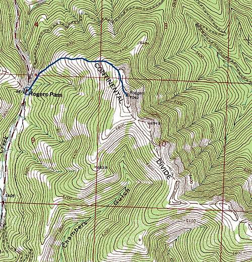
Rogers Peak Route Map
Start up the little ridge and continue up past the cross along the trail and into stands of trees. The single trail will become many fainter trails, so pick whichever route looks easiest up through the trees, staying on or near the ridgetop ahead. Soon you'll reach the first of several openings as the trees give way to grassy slopes. Plod up the steep ridgeline as it gradually curves upward toward the right.
As you gain elevation, you'll be able to look back behind you and see the Continental Divide Trail as it ascends the ridge above the northwest side of the highway. Views to the east and west will open up as well. Simply continue on up the ridge, through isolated stands of windblown trees and patches of talus. You'll ascend a series of humps along the ridgeline and as you approach the west side of the final, rocky hump between you and the summit, you'll join up with the well-maintained Continental Divide Trail. Follow it upward a short distance till it veers to the right around the base of the summit hump. Head up directly toward the summit ridge, angling to the right of the cliffs below the top. Scramble up through an easy break in the cliffs and stroll up the final slopes to the top.
The summit is windswept, with a small cairn and some twisted, stunted dead trees at the top. Snoop around a bit and you'll discover a geocache hidden in an ammo can not too far from the cairn. Some derelict remnants of barbed-wire fencing can be seen strewn about the cliffs below the cairn. If the wind is howling, there are good spots just below the summit cliffs to rest and have a bite.
On the descent, you can opt to follow the Continental Divide Trail instead of descending the ridge. The trail switches back through the timber, so it's less scenic than the ridge but offers some variety in the scenery. The trail meets up with Highway 200 just west of Rogers Pass.
In total, the climb rises about 1400 vertical feet over the course of one mile.
Google Photosphere view from the summit:
Red Tape
The hike is located in the Helena National Forest, and there's no red tape. Park and hike. The area is frequented by hunters during Montana's big game season, so be mindful and wear blaze orange if you're concerned about being mistaken for an elk while hiking in the fall.When to Climb
Rogers Peak can be climbed in any season, although Montana's non-winter months are the obviously ideal seasons. Epic winds can scour the ridge line at any time of year, and they may conspire to form dangerous snow cornices along it during winter, so use caution. The road over Rogers Pass itself can be treacherous in winter; consult road reports and the Rogers Pass webcam for current conditions.Camping
It's possible to car or tent camp in the meadows west of the trailhead at Rogers Pass, but probably unnecessary due to the brevity of the hike.External Links
Rogers Pass WebcamMount Rogers Lookout
Stonewall Mountain Lookout
"Montana Weather: From 70º Below to 117º Above" Published by Montana Magazine
Google Photosphere view of Rogers Peak summit