-
 3634 Hits
-
 73.06% Score
-
 3 Votes
|
|
Route |
|---|---|
|
|
47.09110°N / 12.18070°E |
|
|
Hike and easy scramble |
|
|
A long day |
|
|
Hike and easy scramble |
|
|
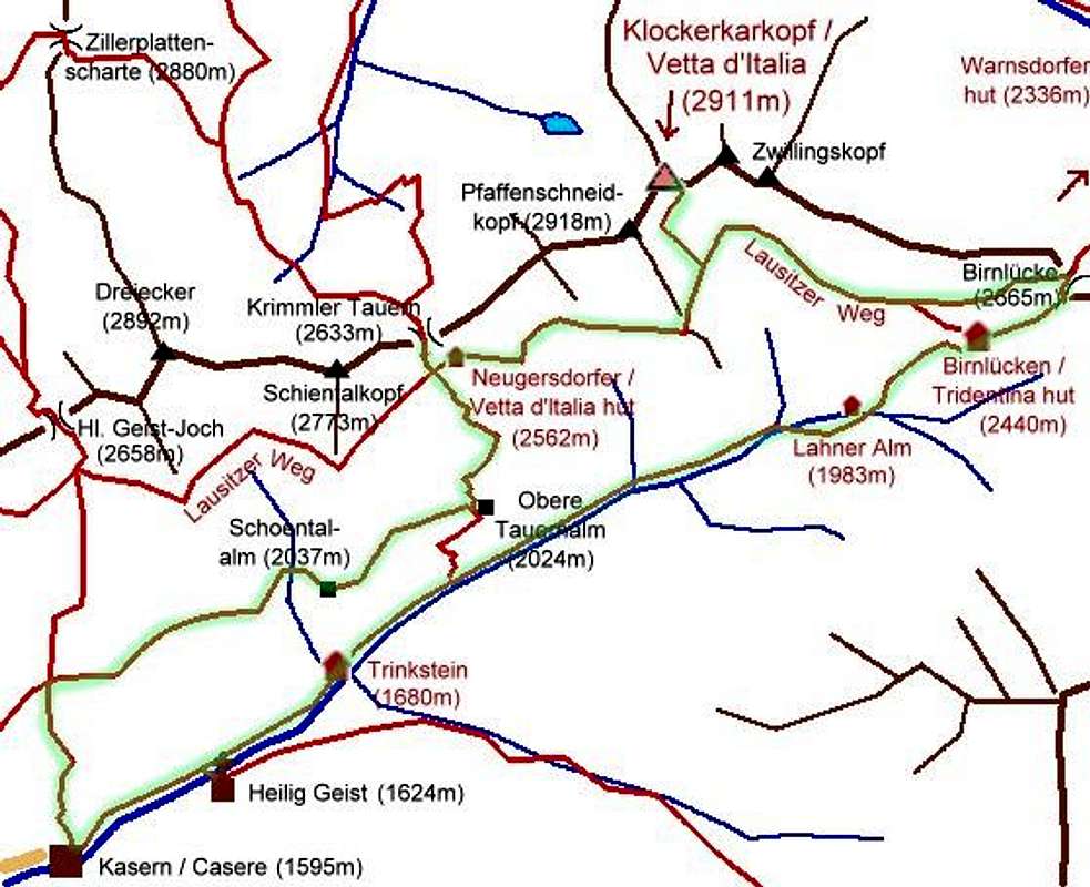
Overview
On this long daytrip you get to know Klockerkarkopf and two important mountain passes, mixed with old and new history. Landscape and views are astonishing.Referring to the guidelines of this fact sheet
General data:
- Start altitude: 1595 m
- Summit altitude: 2911 m
- Prevailing exposition: S
- Type: marked hiking trails, some field of blocks, summit ascent is marked but exposed
- Protection: well marked, some cables near the summit
Effort app. 1700 m ascent if you do all side trips, 1400m if you don't. 6 h ascent, 3.5 h descent
Power: 2
Psyche: 2-3
Orientation: 1-2
Route Description
Starting point: Kasern / Casere (1595m), big parking place, free of charge before 8 a.m.From Kasern (1595m) follow trail Nr. 15 in direction Heilig-Geist-Joechl pass. The trail does many zig-zags but in moderate steepness to cross the zone of larch trees and reaches Starkl-Alm pasture (2029m).
There you follow a macadam road along this terrace with already very fine views to Schoentalalm pasture (2037 m). From there a narrow path traverses the slope to Obere Tauernalm pasture (2018m), where we meet the historic trade route to Krimmler Tauern pass.
This point can be reached quicker but not so nice directly from Kasern following the valley via Trinksteinhaus.


A rather long ascent but along the nicely built old trade trail leads to Krimmler Tauern pass (2633m, italian-austrian border). Fine viewpoint. Short descent on the same route, then a traverse leads to Neugersdorfer Huette hut (2567m, not guided, locked).


This building can be reached directly without the sidetrip to Krimmler Tauern. Now we hike along Lausitzer Hoehenweg trail through meadows and fields of blocks a little down before a short but very steep ascent along the "Teufelsstiege" ("devil's steps", steep wooden stairs) leads to an even part again that brings you to the junction of the summit ascent route.

Red spots lead over slabs, moraines and snow fields to the final rocky part that is steep but secured with some pieces of rope.

Descent
Go down the same route until you reach Lausitzer Hoehweg trail again. Follow this trail until Birnluecke pass (2667m) und descend zur Birnluecken / Tridentina hut (2441m). A short cut is possible to ignore Birnluecke pass.


Further descent along the normal hut trail, first steep on a renovated trail to Lahner Alm pasture (1986m) and further on to Kehrer Alm pasture (1842m). From here a gentle hike on the macadam road brings you back to Kasern via Trinksteinhaus (1667m) – Talschlusshütte and Heilig Geist chapel.


Outline