
-
 1411 Hits
-
 78.27% Score
-
 9 Votes
|
|
Route |
|---|---|
|
|
45.73250°N / 7.81179°E |
|
|
Hiking |
|
|
E |
|
|
Overview
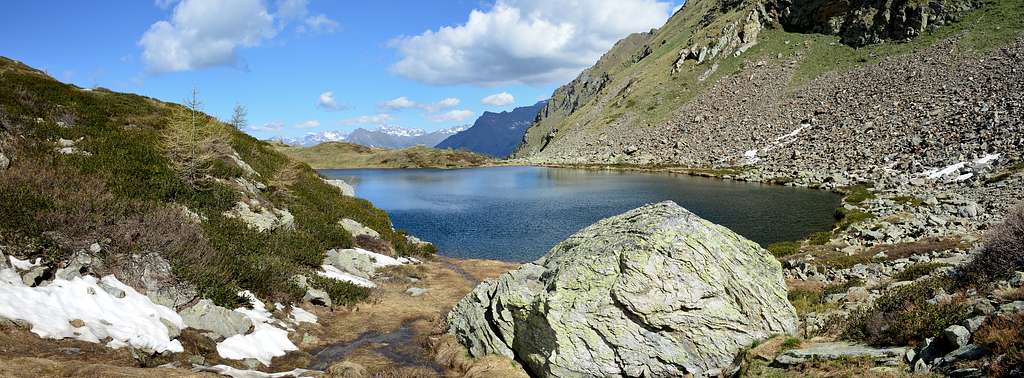
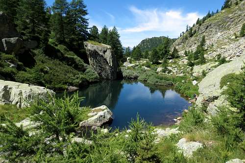
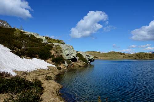
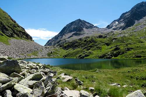
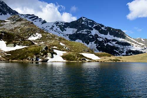
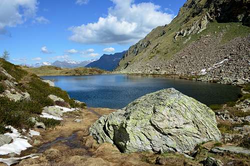
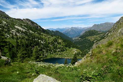
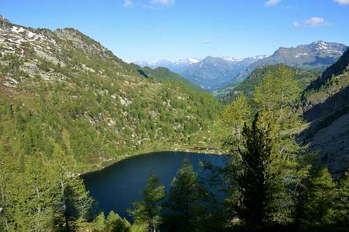
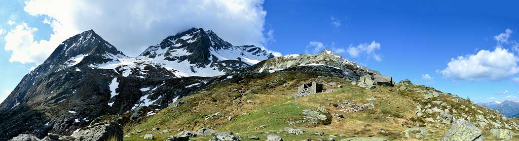
This pair of lakes, which are three if we also want to consider a third tiny lake, almost a puddle, positioned on the Northern shore of Lake Inferiore (2.035/39m), has the characteristic of presenting a large and oblong lake and a rounded or superior one (2.230m), just below the Colle, or better Pass, of Frudiera or Frudière and again for the Walser dialect Frudièrecoll (2.271m). While the approach, with the former path n° 9 but current n° 7, or for those who have the permit with the farm road, is compressed in a long and wild valley, or otherwise through a diagonal paths n° 7/9A coming from the important and renowned Estoul Hamlet (1.818m), that passes through the Colle della Ranzola or Arescoll and the neighboring Pass della Garda, the upper basin that contains the two lakes is located at the foot of the mountain of the same name or Becca di Frudiera but, perhaps, better known as Mont Nery (3.075m). Two long crests branch off from this last one which picturesquely frame the two lakes:
a) - the West-northwest ridge which heads towards Punta di Soleron, Punta di Champlon or Champlong, Forchetta also Fourchette and Cleve di Moula (2.241m) ending above the Hamlet of Graines (1.383/96m) with its magnificent castle.
b) - the North Crest which, after having formed the Marienhorn or Corno Maria (2.767m), turns into the North-Northwest, climbing over Monte Taf, Monte Rena, Monte Taille, Passo della Garda, Punta della Regina to end at the famous Colle della Ranzola (2.171m).
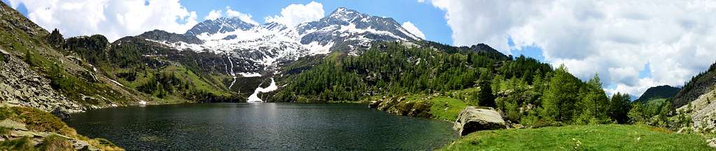
Questa coppia di laghi, che poi sono tre volendo considerare anche un terzo minuscolo laghetto, quasi una pozzanghera, posizionato sulla ponda Settentrionale del Lago Inferiore (2.035/39m), possiede la caratteristica di presentare un lago grande ed oblungo ed uno tondeggiante o Superiore (2.230m), appena al di sotto del Colle, o meglio Passo, di Frudiera o Frudière ed ancora per il dialetto walser Frudièrecoll (2.271m). Mentre l'avvicinamento, con l'ex sentiero n° 9 ma attualmente numerato come sentiero n° 7, oppure per chi possiede il permesso con la strada poderale, é compresso in un lungo e selvaggio vallone, od altrimenti tramite i sentieri n diagonale n° 7/9A provenienti dall'importante e rinomata Frazione di Estoul (1.818 m), che passa per il Colle della Ranzola od Arrescoll ed il viciniore Passo della Garda, il bacino superiore che contiene i due laghi si trova ai piedi dell'omonima montagna o Becca di Frudiera ma, forse, più nota come Mont Nery (3.075 m). Proprio da questo ultimo si dipartono due lunghe crreste che pittorescamente fanno da cornice ai due laghi:
a) - la Cresta Ovest-nordovest che si indirizza verso la Punta di Soleron, la Punta di Champlon o Champlong, la Forchetta o Fourchette e Cleve di Moula (2.241m) terminando sopra la Frazione di Graines (1.383/96 m) con il suo magnifico castello.
b) - la Cresta Nord che, dopo aver formato il Marienhorn o Corno Maria (2.767 m), si trasforma in Nord-nordovest scavalcando il Monte Taf, il Monte Rena, il monter Taille, il Passo della Garda, la Punta della Regina per concludersi al famoso Colle della Ranzola (2.171 m).
Getting There
BY CAR:
From Torino, Milano, etc: Motorway A5. Exit Verrès for then to continue on SR26 for Champoluc Valley. From Switzerland: through the Grand Saint Bernard Tunnel or the namesake pass. Drive to Aosta, Verrès and Champoluc Valley. From France: through Mont Blanc Tunnel or Petit Saint Bernard Pass. It isn't necessary to take Motorway A5: you can drive on SS.26, in the direction of Aosta and Verrès.
Roads Route
Approach from Arcesaz/Tollegnaz and Graines Villages : From Verrès drive to Challand Saint Anselme-Arcesaz (1.146m) and to Graines (1.396m): no thoroughfare mark just at the end of the built up area.
Avvicinamento dai Villaggi di Arcesaz/Tollegnaz e Graines: Dal Villaggio di Arcesaz (1.146 m), tra Challand Saint Anselme e Brusson (raggiungibile da Verrès), prendere la carrozzabile per Graines (1.396 m, palina di divieto di transito alle auto subito dopo l'abitato).
 |
 |
 |
 |
Approach & Route
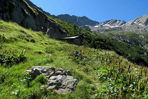
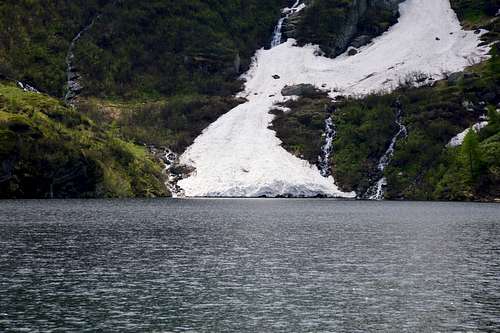
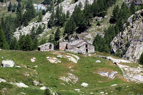
Fron Arcesaz Hamlet (1.146 meters) reacvh Brusson Municipality (1.338 meters), then to follow the farm road along the Graines Valley, bypassing the Fenilia Village (1.668 meters). After to continue keeping the Northern side of the stream, up to the fork 1.508m where you can enter a short cut that crosses it leading to the Charbonniére Pasture (1.628m); cross the Pastures of Restoly (1.682m), Champcharlec (1.766m) and Frudière (1.849m), walk along the right side of the Lower Lake of Frudière (2.035m, 2h'00), ascend the steep slopes to get the Upper Lake of Frudière (2.230m).
INTERESTING NOTE: Wanting to continue to complete this beautiful excursion, reached the Frudière Pass (2.265m, path n° 9), directed to the South-southwest to a stony valley, below the North Face of Marienhorn also Corno Maria. From this point the trail descends to the Valley of Gressoney, but since 2000 it is closed because it dangerously exposed to falling stones, for which I need to go back to Mount Taf with trail n° 1A and then down to Gressoney St. Jean.
 |
 |
 |
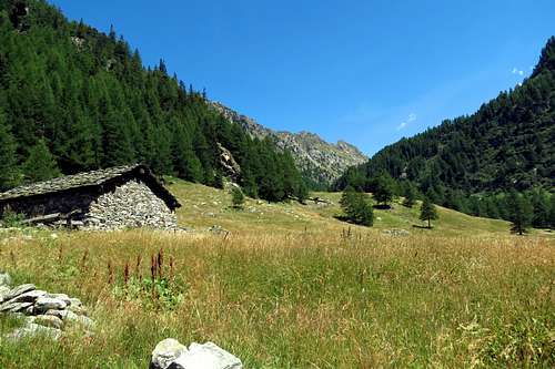 |
Dalla Frazione di Arcesaz (1.146 metri) raggiungere il Comune di Brusson (1.338 metri), donde seguire la strada poderale lungo il Vallone di Graines, oltrepassando il Villaggio di Fenilia (1.668 metri). Quindi proseguire a Nord dell'omonimo torrente sino al bivio 1.508 m, dove una scorciatoia lo guada e porta all'Alpe di Charbonniére (1.628 m); superati gli Alpeggi di Restoly (1.682 m), Champcharlec (1.766 m) e Frudière (1.849 m) costeggiare sulla destra il Lago Inferiore di Frudière (2.035 m, 2h'00); risalire il ripido gradone che porta al Lago di Frudière Superiore (2.230 m).
NOTA IMPORTANTE: Volendo proseguire per completare questa bella escursione, raggiunto il Passo di Frudière (2.265 m, sentiero n° 9), indirizzarsi a Sud-sudovest per pietraie ad un avvallamento, sottostante il versante Nord del Corno Maria altrimenti Marienhorn. Da questo punto scende il sentiero verso la Valle di Gressoney, ma dal 2000 é chiuso perché pericolosamente esposto a cadute di pietre, per la qual cosa bisogna risalire verso il Monte Taf con il sentiero n° 1A, dopodichè si può scendere verso Gressoney Saint Jean.
 |
 |
 |
 |
Difficuty
The route can be classified as E.
L'itinerario è classificato come E.
Gear
For Hiking.
Da Escursionismo.
External Links
- REGIONE AUTONOMA VALLE D'AOSTA the official site.
- FONDAZIONE MONTAGNA SICURA Villa Cameron, località Villard de la Palud n° 1 Courmayeur (AO) Tel: 39 0165 897602 - Fax: 39 0165 897647.
- A.I.NE.VA. (Associazione Interregionale Neve e Valanghe).