

|
|
Route |
|---|---|
|
|
44.00080°N / 71.536°W |
|
|
Hike, Scramble |
|
|
Most of a day |
|
|
Class 1-2 |
|
|
Approach
For the Greeley Ponds route starting from the northern trailhead (Kancamaugus Highway):
Take I-93 to Lincoln, NH (Exit 32). Take the Kancamaugus Highway (rte 112) eastbound a bit more than nine miles (you'll pass the Loon Ski Resort, Hancock Camprground and Lincoln Woods trailhead, Big Rock Campground and Discovery trail, and the East Pond trailhead) until you begin up a switchback on the Kancamagus Highway. The Greeley Ponds Trailhead will be on your right. There's a small lot at the trailhead, and additional parking at viewpoints higher up the hairpin turn, one of which is also the Hancock Notch trailhead. These are usually plowed.
The southern end of the Greeley Ponds trail (about 3.6 miles south of the northeast end of the Osceola Trail, compared to 1.3 miles for the northern trailhead) is 0.3 miles from the west end of the Livermore Trail, which starts on Tripoli Rd about a half mile from the Waterville Valley ski area. Ample parking, usually plowed.
The rest of this page assumes you've started at the northern trailhead.
Route Description
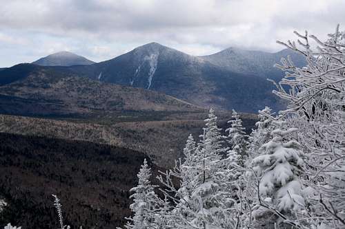 view from the slide
Greeley Pond Trail 1.3 miles
Mt. Osceola Trail 2.5 miles
Total Roundtrip Hike 7.6 miles
This route is the much tougher of the two route to the top of Mt. Osceola. While the Tripoli Road Route is a gradual hike, this trail includes steep sections and often very poor footing. Despite its steepness, this route has a lot to offer hikers, especially the beautiful brooks on the way to Mad River Notch.
From the Greeley Pond Trailhead on the Kancamagas Highway, take the Greeley Pond trail southward (an easy uphill stroll) 1.3 miles. You will ascend gently over numerous brook crossings, many which are bridged. The ease of this part of the hike gives no hint at what is to come on the Mount Osceola Trail.
At 1.3 miles, right at the height of land (called Mad River Notch), you will come the Mt. Osceola Trail. The Osceola Trail begins out moderately up under cliffs. The trail then takes a right turn past the cliffs and for a half mile climbs fairly steeply to the side of an old slide. At the top of the slide is a side trail to a beautiful overlook of Mt. Kancamagas and Upper Greeley Pond. The trail then summits a knob, and the ascent up East Osceola then becomes more moderate. As the trail comes closer to the summit of East Osceola it becomes steep once again.
At 2.8 miles of often difficult climbing it reaches the top of East Osceola (4156') and its view of nothing but the trees right in front of you. Not much of a reward for hard effort, but if you follow the ridge a few steps in either direction you can get glimpses through the trees.
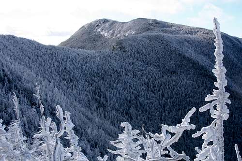 Osceola from East Osceola - Chimney at center
Next the trail descends into the pass that lies between East Osceola and Mt. Osceola. Great views can be seen of Mt. Osceola and the rest of Scar Ridge. After hitting the low point of land the trail then ascends a very steep chimney (which can be avoided on the right) and continues to ascend up alternating moderate and steep rocky pitches up to the top of Mt. Osceola where fine views await you.
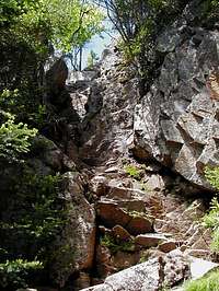 The Chimney
Essential Gear
In summer nothing more is needed except hiking boots, tons of water and essential hiking gear. Essential gear includes bug spray in June (black fly season). Due to the mud season avoid this trail in April and May. The Mt. Osceola Trail is naturally steep at this section, and a lot of friction on this trail will only erode it even more.
In winter this can be a rough climb. Some form of traction is recommended, and snowshoes may be needed after a heavy snowfall. A good pair of hiking poles will be very helpful for some of the tougher spots on this trail. Though there are steep sections, exposure is minimal (there is one spot where you cross a small slide, and of course there are open ledges on the summit of Mt Osceola) so an axe probably wouldn't be useful.
Miscellaneous Info
If you have information about this route that doesn't pertain to any of the other sections, please add it here.