
-
 8934 Hits
-
 73.06% Score
-
 3 Votes
|
|
Route |
|---|---|
|
|
46.05410°N / 7.61730°E |
|
|
classical mountaneering |
|
|
One to two days |
|
|
AD-, UIAA III, G 6 |
|
|
Getting there
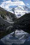
You have to drive into the Val d'Annivers which begins near Sierre in the main valley of the Valais/Wallis. From Vissoie a road leads to the pittoresque village Grimentz and further to the dam wall of the Lac de Moiry reservoir (2254m). At the end of the lake there is a big parking and also the final station of swiss bus service PTT. |  |
Approach
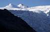
A nice path follows the eastern moraine of the Glacier de Moiry and leads more steep to theCabane de Moiry (2825 m)
600 m ascent, 2 h, easy hiking (BW 1 in the swiss hiking scale).
This is a lovely walk in beautiful landscape and therefore very popular for tourists.
The hut is guided from July to September and open during the rest of the year (such as all huts of the swiss alpine club).
 |  |  |  |
Route Description
A small path leads in 30 min to the beginning of the glacier which is entered above the seracs.. First you have to pass at the bottom of the Pigne de la Lé. (It's summit can be climbed easily from the upper plateaau of the glacier. It is a nice panorama mountain). Climb gentle slopes (some crevasses, taking the rope is a must!) until you reach the ridge at the "Bouquetins". Follow the easy ridge or traverse the snow hill to the topmost part of the glacier which ends at the final rocks of the Grand Cornier fore-summit. Climb this steep slope (we had some ice with about 40°) and traverse it to the west ridge of the fore-summit where some easy rocks lead to the top (3843 m), 3 h from the hut.If you go there with ski in spring this is probably the end of your ascent.
 |  |  |  |  |
final ridge
From the fore-summit to the main summit leads a rocky ridge, narrow and with some towers. Sometimes there are possibilies to pass them on the east side, one is to pass on the west side where a little rope helps; 1 h from the fore-summit, much longer if you belay (as we did, it took us 3 h then). | 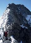 |  |  |  |
difficulty
My guidebook "Walliser Alpen" by Michael Waeber (Bergverlag Rother München, 10th edition 1993) rates the Route with G 6, that means ZS-/AD- and tells the difficulty of the rocks with UIAA II at the summit ridge.My friends and I thought that some parts of the ridge are definitely UIAA III
We were very surprised when we had a look in the 12th edition of the same guidebook: now the climb is rated G 7 and UIAA III.
UIAA III is okay but G 7 is definitely too high. There is no problem in finding the route and the climbing difficulties concentrate on the final ridge. So this cannot be compared to climbs where you are the whole day in exposed terrain like Weisshorn normal route or so.
Surely the south west ridge of Grand Cornier from Dent-Blanche-bivouac - also rated G 7 - is more difficult.
Essential Gear
50 m single ropecrampons, ice axe for the glacier and for some parts of the ridge when icy; a few quickdraws and loops of webbing. There are some bolts.
rock climbing gear depends on how much you want to belay
Map
Swiss maps1 : 25.000 Nr. 1327 Evolène
1 : 50.000 Nr. 283 Arolla, also available with ski routes