
|
|
Route |
|---|---|
|
|
47.42000°N / 13.05000°E |
|
|
Scramble |
|
|
Half a day |
|
|
Walk up |
|
|
Approach
The base can be either reached from Mühlbach am Hochkönig or from Dienten following the Hochkönig Bundesstraße (main road connecting Mühlbach and Dienten). From Mühlbach use the main road to Dienten and Saalfelden. Before reaching the Dientner Sattel (mountain pass 1363m) approximately 500m after crossing a mostly dry torrent you will find a small parking place on the right side of the road. Stop here.
From Saalfelden and Dienten cross the Dientner Sattel and go down on the other side for about 1,5km to reach the parking place (1290m).
Route Description
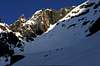
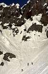
From the parking place you have already a good view of the Hochkönig and the Birgkar, a huge cirque which steepens in the upper half significantly. Follow a small road straight into the Birgkar. When the road turns to the Stegmoosalm keep going on into the cirque. At a height of about 2000m the area becomes rocky and rather steep (35-45°). The most common route leads through a gully on the left side, but take care as avalanches might come down in this gully. Additionally cornices hanging on the ridge at the left side may collapse (in spring time I could observe collapsing cornices several time at this place) If the snow conditions are ok it is possible to ascend on the right side above the gully (here it is steeper but more secure).
At a height of about 2600m below the south face of the Kematstein you have to traverse to the right (East) to a large snowfield. Thís traverse might be tricky when it is icy (some ropes have been fixed there). The snowfield leads directly to the Birgkarscharte (2847m) which is the gate to the karstic and glaciated plateau of the Hochkönig.
For skiing down use the same route. If the snow conditions allow the steep gully hich starts at the traverse can be skiied down. Another route starts at the uppermost snowfield. Traverse to the East (when you go down to the left) under the south wall of Hochkönig. If you plan to ski down this route you should study it very carefully since it is rather difficult.
 |  |  |  |  |
More Photos of the Route
.
 |  |
Essential Gear
Best time to ski the Birgkar is March and April when the danger of avalanches is lower. Nevertheless I found perfect conditions (firn snow) as soon as early December.
Since the Birgkar opens to the SE you will have to start early in the morning. Crampons might be helpful when the snow is frozen.
Although the tour is steep (35-45°) in the upper half it is rather popular. Difficulties may arise due to hard snow.
Before starting always have a look at the weather forecast and the avalanche situation.
Miscellaneous Info
If you have information about this route that doesn't pertain to any of the other sections, please add it here.