
-
 12408 Hits
-
 76.5% Score
-
 7 Votes
|
|
Route |
|---|---|
|
|
36.29940°N / 115.6478°W |
|
|
Hike / Occasional Scramble |
|
|
Most of a day |
|
|
Walk-up |
|
|
Approach
From the Trail Canyon trailhead, follow the well-maintained trail for about 2 miles until it reaches an obvious junction with the North Loop Trail. From here, hang a left and start following the North Loop Trail to the north toward Mt. Charleston.(Note: If you were to take a right on the North Loop Trail at the junction, you would find that it heads down and ultimately takes you to the North Loop trailhead, which is about 3 miles away and located off of the Deer Creek Road (highway 158). This stretch of the North Loop Trail from the Trail Canyon junction to the North Loop trailhead, while steering you away from the common "tummy" route, will take you to the "Raintree" and put you in the vicinity of Fletcher Peak)
Once on the North Loop Trail traveling toward Mt. Charleston, follow the obvious path as it starts to gradually ascend and ultimately traverse below the imposing limestone cliffs of Mummy's west side. After a mile or so, you will pass a wooden trough with a pipe draining water into it. This is Cave Spring. The water may or may not be drinkable. Play it safe and filter it. Cave Spring is a nice spot to catch a breath, and through the thickening forest in this area, you can just make out Mt. Charleston and Griffith Peak on the other side of Kyle Canyon.
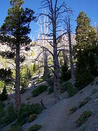
From Cave Spring, continue on the trail. You will soon find yourself walking through a nice section of aspen. Before long, the trail will start to move away from Mummy Mountain and begin following the main ridge toward Mt. Charleston. Don't fret it, the trail soon starts to switchback up and move back toward Mummy.
After a half mile or so, the trail empties out of the aspen groves you have been passing through and you will find yourself at the base of a 1000 foot avalanche slope below Mummy Mountain. This spot will be apparent...it's the first open slope you will have encountered on the route. The slope is scree-covered and dotted with the occasional bristlecone. Although the trail will switchback up once or twice and then ultimately head directly toward Mt. Charleston, it is at the base of this slope that you will leave the trail.
 The Mummy Tree
Route Description
Head directly up the scree slope toward the ridge above. You may want this ridge to be Mummy's summit ridge, but it's not. Once the ridge is gained, follow the crest of the ridge to the right (southward), negotiating class 2 and occasional class 3 terrain until you start to notice that the ridge forms the west side of a northwest-facing bowl. Continue traveling the ridge, following the occasional use trail that pops up here and there, until you find yourself nearing the top of the bowl. Near the top of the bowl is a trail that traverses to the other (east) side of the bowl, where you will see an imposing set of high limestone cliffs - the summit of Mummy is at the top of those cliffs.Follow the trail to the base of the cliffs on the east side of the bowl. From here, the trail skirts the bottom of the cliffs and travels north. You will pass a couple of steep, rocky chutes along the way, but you are looking for an obvious one that the trail ultimately leads you to. It's only a short distance - a 1/4 mile or so.
Once you find the summit chute, start scrambling up it over loose scree and talus. The chute is about 200 feet, steep, and could be intimidating to some, due to the loose nature of the crap in it.
At the top of the chute, the terrain starts to mellow out. From this point, you can start to walk erect again. Head due east onto the sprawling summit plateau.
The Mummy Mountain highpoint is found only 100 yards or so away to the southeast. It is at the top of a pronounced bump on the plateau and is marked with a cairn. Welcome!
 |  |