
-
 8476 Hits
-
 71.17% Score
-
 2 Votes
|
|
Route |
|---|---|
|
|
38.84040°N / 105.1045°W |
|
|
6 mile off-trail hike with summit scramble |
|
|
Half a day |
|
|
Summit scramble - Cl. 3 - Approach - easy Cl. 2 |
|
|
Approach
The beginning point for this route is Devil’s Playground located just after Mile 16 on the Pikes Peak Highway. Take U.S. Highway 24 west from Colorado Springs. After passing exits for Manitou Springs, Manitou Cliff Dwelling, Cave of the Winds you will continue up Ute Pass. Not long after passing the popular Waldo Canyon trailhead on the right, you will approach a traffic signal which is the turnoff for Pikes Peak Highway. If you are approaching from Woodland Park to the west, this intersection is well signed.
Turn left at this traffic signal, or right from Woodland Park, and follow the signs until you arrive at the tollbooth. You will pay $10 per person or $35 per vehicle, whichever is less. It is possible to buy a $75 individual season pass or a $100 family season pass. During the summer the gate opens at 7:00am and you should be there at this time for this route.
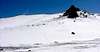
Proceed up Pikes Peak Highway to just past mile marker 16 to the Devil’s Playground parking area on the right. Devil’s Playground is at approximately 13,000 feet elevation and got it’s name from the way lighting dances among the rock outcroppings during afternoon thunderstorms. Start and finish this route early as the entire 6 mile roundtrip is above tree line. Bailing below tree line to the west of Sentinel Point will put you on Highway 67 which is a long way from your vehicle.
 |
Route Description
From the parking area you will head south out of the parking area on an old road which quickly turns to the west on the south side of ridge passing through some neat rock formations. This ridge separates the cirque above Glen Cove to the north which was visible from the highway and the West Fork of Beaver Creek drainage to the south. After crossing this connecting ridge you will turn south and travel along the crest of the great ridge between the west fork of Beaver Creek to the east and the Crags and Horsethief Park to the west.
Once on top of the ridge you will notice that the crest of the ridge beyond is blocked by a large rock outcropping which would make an interesting climb itself. Off to the right of the ridge crest will be your first view of Sentinel Point with Rhyolite Mountain just behind and below to it’s right. On a good visibility day, you can see the Spanish Peaks and Wet Mountains to the south, the Sangre de Cristo’s to the southwest, much of the Sawatch and Mosquito Ranges to the west and the Northern Front Range including Long’s Peak to the north. Outstanding!
Prior to the large rock outcropping you will head down and to the west of the ridge crest towards Sentinel Point. Be sure to stay to the east of the large drainage dropping into Horsethief to the north of Sentinel Point. After descending off the ridge look back and make a mental note of the point on the ridge at which you exited to aid in route finding back to the ridge later.
Once to the saddle below Sentinel Point take a look around. To the south is the head of the Oil Creek drainage. To the north is the Crags. To the southwest you will have to pick a Class 3 route up Sentinel Point itself.
From the summit the views are great. To the west is Horsethief Park. If you summit early, bring your binoculars and a knowledge of Colorado Peaks, you could sit up here identifying peaks for a long time. Unfortunately I didn’t have a telephoto lens. Maybe next time!
Notes:
This hike drops from around 13,000 feet at the trailhead to about 12,200 at saddle below Sentinel Point which will have to be gained on the return to the trailhead.
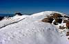
All of the pictures referenced here were taken on June 11, 2005 after a nice 6” snowfall the night before.
 |  |  |  |  |
Essential Gear
The entire 6 mile route is above tree line so dress appropriately. Start early as the only bail out point in inclement weather is to drop below tree line into Horsethief Park placing you miles from your vehicle. You may want to throw gaiters and traction device such as Yak-trackers in your vehicle in the event of recent snow.