
|
|
Route |
|---|---|
|
|
39.12310°N / 106.9741°W |
|
|
Scramble on semi-loose rock |
|
|
A long day |
|
|
Tough class 3 |
|
|
Approach
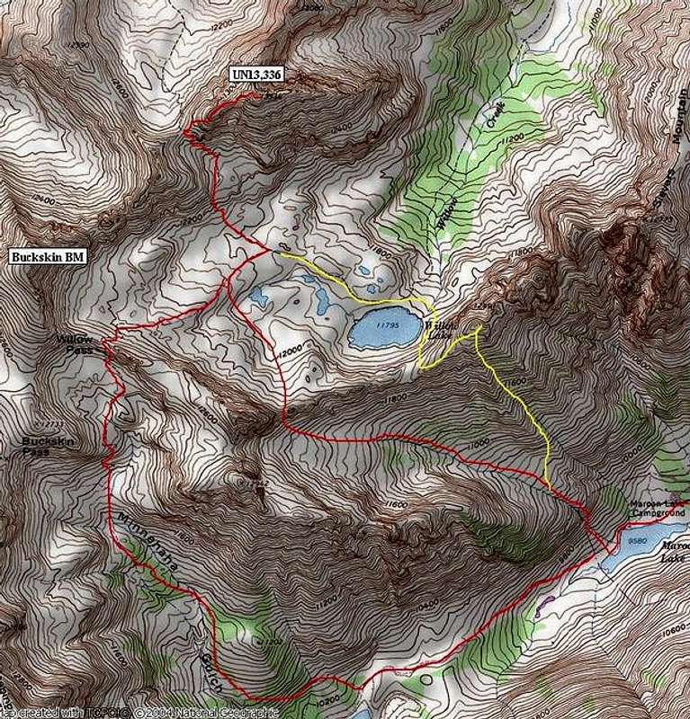
Round Trip=9 miles and 4,000-ft (with a side trip to “West Sievers”)
Starting at the Maroon Creek TH (9,570-ft) locate the Crater Lake Trail and hike 1.69 miles to Crater Lake. At the east end of the lake the trail splits. Leave the Crater lake Trail and take the Maroon/Snowmass Trail and start your ascent up into Minnehaha Gulch. The trail will steepen here and become single track. This trail will eventually lead to Buckskin Pass.
Ascend this trail 1.63 miles and 1,650-ft into the upper ramparts of Minnehaha Gulch and look for the Willow Lake turn-off, it is signed. Take the Willow Lake Trail and hike up into a northern spur drainage and on to Willow Pass at 12,560-ft.
From Willow Pass, descend on a good trail a few hundred feet into the Willow Lake Basin and get a good view of UN13,336 and the pass just to the southwest of the summit. That pass will allow access to East Snowmass Creek Drainage and it’s also the starting point for the West Ridge Route on UN13,336. Make your way on good ground to the above-mentioned pass at 12,700-ft.
From this pass, the ridge looks tougher than it really is. However, the route is loose and the climbing easily reaches class three. Route finding is key on this climb, loose class 4 is only a few feet away the entire route.
Route Description
Begin by ascending some loose, and annoying Maroon-like sandy benches. There are a few headwalls to negotiate, but easier ground is mostly on the left side of these headwalls. Soon the ridge narrows, and from here it is important to stay as close to the ridge crest as possible. Once you leave the red Maroon-like rock and enter the white Capitol-like rock you will notice the route becomes more solid and easier to stay close to the ridge crest. On the ridge crest expect huge exposure to the east and occasional exposure to the west.
Climb the west ridge to a junction of sorts for two different ridges, the west ridge (that you are on) and the seldom-climbed north ridge. From this spot the summit is very close and it feels almost like you are in a saddle of sorts. Go right and ascend the extremely loose east ridge 100-ft to the summit. This is the most dangerous place on the climb.
For an alternate descent that takes you directly back to the Maroon Lake TH, hike across the Willow Lake Basin to Willow Lake. Ascend the grassy slope to the saddle just south of “West Sievers Mountain” which is an easy class 1 hike to its summit. (see TOPO) It’s a worthy side trip if you have the energy; the views of the Maroon Creek Valley are to die for.
From this summit you can see Maroon Lake almost 3,000-ft below. Descend to 11,500-ft and traverse into an obvious basin to the south. At 11,000-ft locate an important trail that will take you all the way back to the trailhead. It’s not a obvious trail, but it is there. If you find this trail, the rest is history. This trail will escort you down the remainder of the slope, including a really steep section of slope. During this stretch it stays high on a narrow ridge, down through the trees. Without the trail, it would be difficult to descend this section.
Essential Gear
Helmet and a good alpine start.