
-
 12300 Hits
-
 83.57% Score
-
 17 Votes
|
|
Route |
|---|---|
|
|
54.56569°N / 2.91138°W |
|
|
Mountaineering |
|
|
Half a day |
|
|
Varied |
|
|
Overview
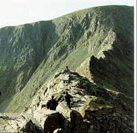
 View from the end of the ridge april 06
A grand day out on one of the Lake Districts finest mountains.
This mountain can have ALOT of people on it, but don't let that put you off.
This route takes you up a gently rising traverse, without you having a clue as to what you will see or travel over. Until that is, you reach the hole in the wall..................................................
The ridge is a spectacular place. In the summer it is an airy magical place with views to die for.
In the winter it is as, or maybe even more beautiful. But it is not a route to take lightly, in bad conditions it has many factors that can prove it to be alot more dagerous.
The decent can be made via many routes too.
Getting There
 looking along the ridge to Striding edge
This route is started from Either Patterdale or Glenridding. Both have ample parking to be found.
To get there, use the A592 on the west side of Ullswater.
From the south. M6 to Jcn 36. then A590 north to A 591 to Windamere, then Ambleside taking the turning at the small roundabout to the Kirkstone pass A 592, following the road down past Brothers water to Patterdale.
From the north. From the M6 jcn 40, turn westbound signed Keswick. Take A66 to first Jcn Signed A 592 Ulswater, continue to Glenridding.
Route Description
 Looking down from the slope up to the summit plateau. The lump of rock this end of the ridge is where the 'bad step'is, the only technicaly difficult part of the ridge
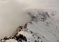
The most common route to Striding Edge is from Patterdale or a longer walk from Glenridding.
The target from either route is to reach the 'Hole-in-the-Wall', named on the O.S 1:25,000 map.
From the Hole-in-the-Wall where you will cross a stile at 700m, there is a stony gentle incline, until you reach the beginings of a rige and then rock tower overlooking the full length of the finest ridge in the Lake District at an elevation 0f 850m. Crags and scree fall away from either side giving (if you are lucky not to be amungst the cloud already) a breathtaking and quite dramatic scene not easily captured on any media appart from the eyes.
The traverse of the ridg's top is relatively easy in normal conditions and can be made easier if need be, by following the path that exists alongside and lower than the main ridge route at varied intervals, mostly to the left but ocationally to the right.
Exta care should be taken when there is a high wind or ice as it is a very exposed ridge - a fall from here would, at many locations along the way be almost cirtanly fatal.
The only part of the ridge that is technicaly dificult (grade 2 scrable) is at the Helvellyn end when a scramble is required to descend a 20 foot chimney on quite good holds.
The distance from the Hole-in-the-Wall to the summit of Helvellyn is a distance of 2km with a total ascent of 260m.
Once off the end of the rigde you find yourself in a slight dip faced with a final challenge.
The encline in front (60m or so) is a steep mix of brocken rock, pleasent grooves and grass ledges. You can pick a varied route depending on what you like. But as you ascend the route tends to go slightly right.
In snow conditions this can be a hugely enjoyable part of the route with a possible cornice to tackle or avoid. My first ascent from Striding edge was in over a meter of powder snow!
Once over the rim, onto the summit plateau, you have a short walk NorthWest accross a barren waste, with an erroded by wind and cold feel to it.
The summit is greatfully equiped with a cross of drystone wall, for a shelter. And as there are no other places to get out of the wind other than over the cliff edge, its a welcome retreat.
The Decent
Once you have had your fill of food or views you have to decide a way down.
The most sporting of which, is Swirral Edge.
Continue along adjacent to the Cliff edge on your right (North East)past the Trig point, about 100M to the what seems to be a dead end on the plateau. As you approach the edge (marked by a small cairn) you suddenly see there is a well worn path dissapearing over the edge. Follow down taking care in wet or icy conditions down to about 800M.
Now you have the further choice of route.
Down via Red tarn and the way you came, up and over Catsye Cam, Red tarn beck, or in between the two....along next to the wall towards Birkhouse moor, and down via little cove.
Alternatively, from the summitthere is also the option of returning via the southern ridgewalk. Over the well defined path that skirts over and arround first Nethermost Pike, then the western flank of Dollywagon Pike joining the zig-zag path down to Grizedale tarn. Then turning around Tarn crag back Noth Eastwards along the track down into Grisedale valley. This is a long ramble back to patterdale, but in a beautiful situation, with great views of the Helvellyn range as you near the end of the valley.
Essential Gear
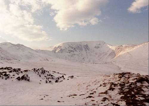 Taken from 'the hole in the wall' the path to ridge starts on the extreem left skyline, Helvellyn summit plateau is centre with Swirral edge seen coming down from the right of it
 As early as the 1850s a local man fell to his death in the fog, and since then many have succomed to poor weather, high winds and snow and ice, ending in injury.
Dont be put off from discovering the secret beauty of this favorite mountain, but have respect and be fully prepared.
So, remember this is a rugged route. Helvellyn gets more snowfall than most of the Lakes. The winds can be very fierce, even though the valley is calm and tranquil.
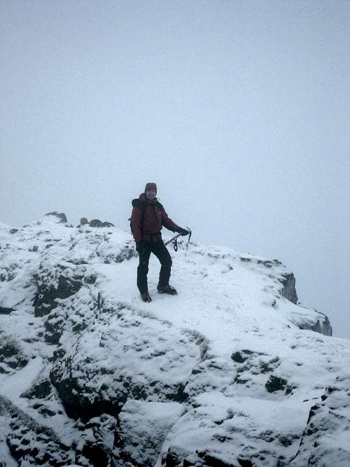 Just before the Edge proper
So read the forecast and take heed.
Crampons and Ice axe should be carried if you suspect any ice or snow.
A water and wind proof shell is always advisable on English mountains, as is good sturdy footware.
And use a map Out door Leisure 5 1:25 000 Is ideal
External Links
---------------------------------------------------------------------------Helvellyn Website. Containing area info, shopping,walks, pictures,places to stay and more...... www.helvellyn.com
---------------------------------------------------------------------------
Leanys lakes Some great info and pictures
---------------------------------------------------------------------------
Striding Edge website Area info, Helvellyn page
---------------------------------------------------------------------------
YHA yha lakes
---------------------------------------------------------------------------
Lakes weather Forecast www.escape2lakedistrict.com
---------------------------------------------------------------------------
Mountain Conditions + daily picture (winter)Helvellyn weather>www.lake-district.gov.uk/weatherline
---------------------------------------------------------------------------