
|
|
Route |
|---|---|
|
|
40.71100°N / 109.828°W |
|
|
Hiking, Scrambling |
|
|
Summer |
|
|
One to two days |
|
|
Class 2+ |
|
|
Overview
This is a good route to test your orienteering skills. Trails marked on the topo maps bear no relationship to reality. This is a longer route to Marsh Peak than the one from the east, but the solitude is very enjoyable.Getting There
Make sure to have a good map before driving to the trailhead. This is how we found the road in 1994, but things do change because this is an active logging area.From Roosevelt on Highway 40, drive east along Highway 40 to 8500 East near Fort Duchene. Turn north on 8500 East. The road curves around to the east and becomes 9600 East and heads north to 7000 North. Turn right on 7000 North and drive east to the tiny town of Lapoint.
From Lapoint, drive north on FR (Forest Road) 104. Follow FR 104 to just short of the turn-off to Paradise Park Reservoir. Notice the road going past Mill Pond on the map. This is your road. Drive the 4wd road past Mill Pond and continue north. Continue along the rough road to a sign and 4-way junction. Park here.
If you don’t have a 4wd, you can park at Paradise Park Reservoir and hike to the 4-way junction, but the trail can be hard to find among the old logging roads. Make sure to have and use a good map.
Route Map
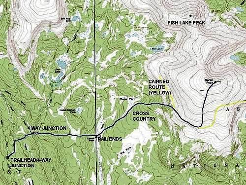 Paradise Park/Corral Park-West Slopes Route to Marsh Peak.
Route Description
This is how the trail/route appeared in 1994. Trail conditions may have changed, and since there was a new bridge constructed in 1994, the trail may have been improved (?). If you use this route, please post any updates.Make sure to have a good map and compass, or GPS, before attempting this route. From the trailhead, follow the trail to the east (right). After about one mile, the trail will reach a 4-way junction. Turn right and cross a new bridge and follow the good trail to Corral Park. There are some good campsites here. In 1994, the trail ended here.
We wasted much time looking for the trail heading east towards Marsh Peak, but never did find it. In places, there were a few trail markers and scraps of trail, but for the most part, the trail was non-existent. It is probably best just to head cross-country towards the peak using a map and compass, and forget about trying to find the trail.
Using a map and compass, hike to Macks Park, which has some good secluded campsites, and head towards Marsh Peak (the Macks Park meadow itself is marshy, so stay on the forest edge).
Continue east to the peak. You will intersect a north-south trail/cairned route at or near timberline. From here, you can climb directly to the summit of Marsh Peak by heading east through the boulders. The easiest way, however, will be to follow this cairned route south and along the mountain to Marsh Peak’s south slopes. From there, just route-find north and hike to the summit.
Note: Where you intersect the trail/cairned route mentioned above, you can head north a short distance and down to Fish Lake. This is well worth the side trip, and there are good campsites at the lake.
Alternate Route:
This is another possible variation of the route. It is a bit longer, but the trail is probably in better condition, and it may actually be faster. See above about the 4-way junction a mile from the trailhead. You can take the trail north to Twin Lakes. From there, a trail heads east to Fish Lake (see above paragraph). At Fish Lake, it looked like the trail was in OK condition at that point, so it may be easier to follow than the route through Corral Park and Macks Park that we took.
From the summit of Marsh Peak, you can continue north on the ridge over a sub-peak of Marsh and to “Fish Lake Peak”. From there, you can either return to Marsh Peak, or route-find down to the Fish Lake area.
The route to Marsh Peak and back is 11-12 miles round trip from the trailhead, but with all the cross-country travel, it would be a very long day hike. Two days is recommended, especially if you plan on climbing Fish Lake Peak as well.
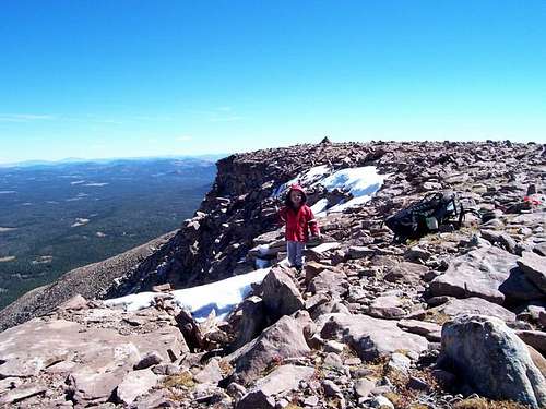 Near the summit of Marsh Peak.