
-
 72795 Hits
-
 91.02% Score
-
 34 Votes
|
|
Route |
|---|---|
|
|
45.83302°N / 6.86491°E |
|
|
Mountaineering |
|
|
Summer |
|
|
One to two days |
|
|
PD + (Alpine Scale) |
|
|
Overview
3 Mounts Blanc Traverse
The ascent to Mont Blanc is a long and tiring climb, but it gives a great satisfaction as it is the highest and the most prestigious summit of the namesake massif. The "Normal" routes are two on the French side and one on the Italian side: the easiest is the one climbing up from Chamonix to the recently reconstructed Refuge Gouter, to then follow the Arête des Bosses. The second one is slightly more difficult starting from the Refuge Cosmiques and climbing through the 3 Mounts Blanc, or Mont Blanc du Tacul, Mont Maudit and finally Mont Blanc.
The 3 Mounts Blanc Traverse is probably the longest and the most panoramic amongst the Normal Routes to join Mont Blanc summit. It starts from the Aiguille du Midi and ends on the summit of Mont Blanc. For the descent route you will have the choice between the Dôme du Gouter Normal Route, the Grands Mulets Route or by coming back again to the Aiguille du Midi. Note: The 3 Mounts traversee follows the Mont Blanc du Tacul and Mont Maudit Normal routes in the first part of the ascent.
Getting There
The starting point is Chamonix Mont Blanc.
Getting to Chamonix
- coming from Italy: go through the Mont Blanc Tunnel, joining directly Chamonix
- coming from Switzerland: you may come from Martigny by driving up the Forclaz Pass and the Col the Montets, or from Geneva using the "Mont Blanc highway".
As you reach Chamonix you will certainly see the cables of the enormous cable car of the Aiguille du Midi... You can't be wrong. Take the cable car up to the Aiguille du Midi and follow the indications "Alpinist Exit" as come on the top of the Aiguille. (If you have a few time, visit the panoramic terrasse of the Aiguille du Midi, you will appreciate the entire route up to the summit of Mont Blanc.
Route Description
Three Mounts Blanc traverse report - UIAA Scale
Summit altitude: 4810 m
Difficulty: Alpine PD+
Difference in level: 1200 m Refuge du Cosmiques
Huts and bivouacs: Refuge du Cosmiques 3613 m
Starting point: Chamonix
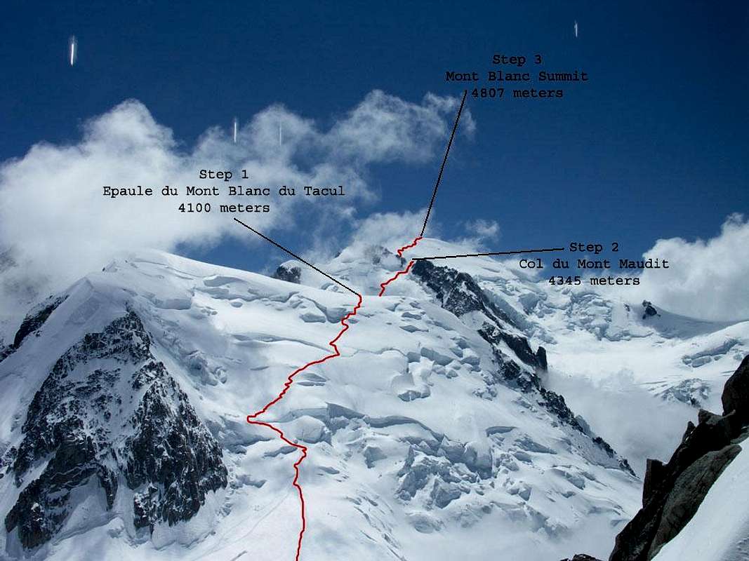
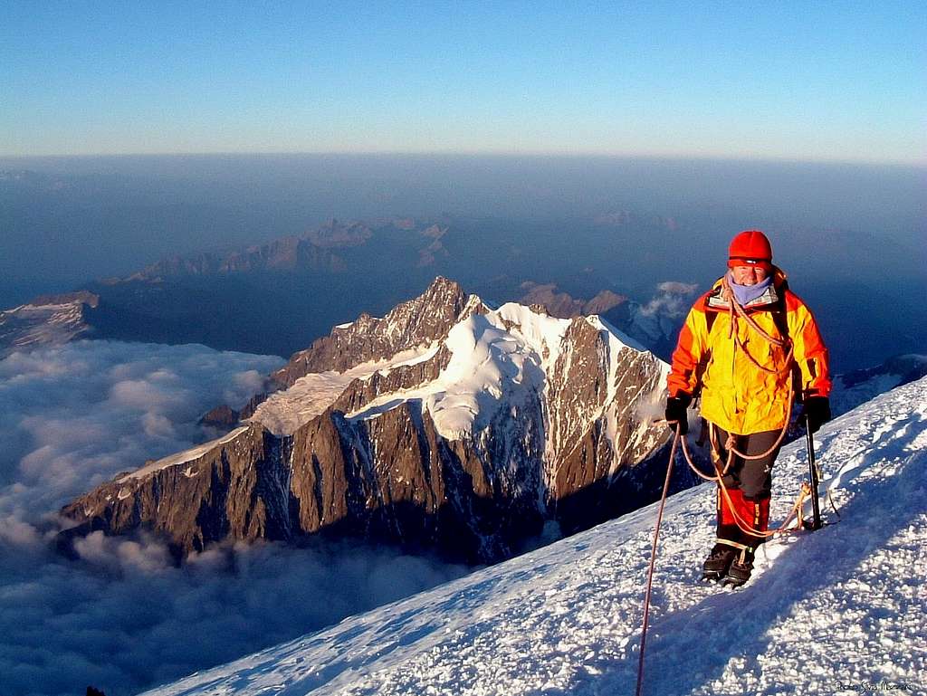
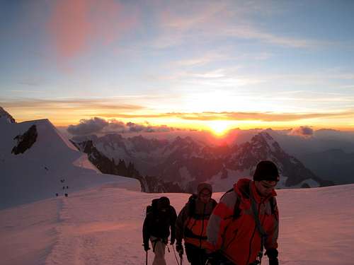
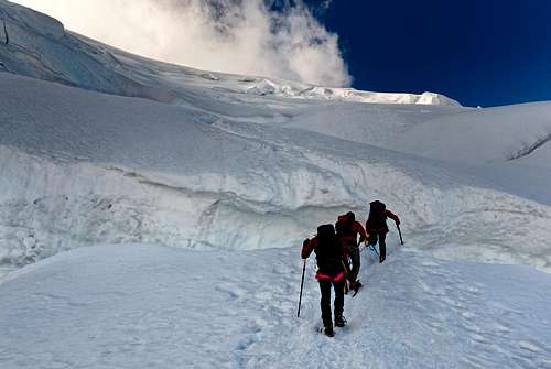
If you sleep at the Cosmiques Hut, leave it ar around 1.30 AM and reach the Col du Midi (3532m) 100 meters below. From here walk south and begin climbing up the North face of the Mont Blanc du Tacul. The face becomes steeper and you will have to walk around some seracs and crevasses. The route changes every year or even more frequently because of the glacier movings. This first step brings you to the Epaule du Mont Blanc du Tacul at around 4100 meters.
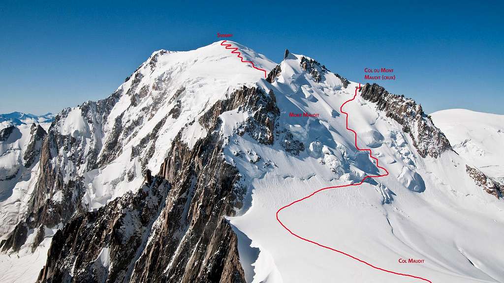
From the Epaule go on walking south until the Col Maudit (4035 meters) and from here move to the right to join the North Face of the Mont Maudit. The face is really steep but less dangerous of the fisrts one because of the seracs. The North Face ends with a 40-50° degrees ice climb to reach the Col du Mont Maudit (4345m). This key passage is often the point where people decide to stop the climb. As you have crossed the Col du Mont Maudit you walk south once again to reach the Col de la Brenva (4303) and from here once again to your right to climb up the steep wall of the Mur de la Côte. Over this wall you stand on the Plateau de Petits Rochers Rouges (~4550 meters). Now you just have to walk up in N-W direction to the summit of the Mont Blanc (4807 meters). The ascent will take you around 6 hours depending on the seracs conitions and the people on the route.
Descent
The descent from the same route is quite long and when you have finished the descent reaching the Col du Midi (3532 meters) you will have to climb up 300 meters to take the cable car on the Aiguille du Midi (3842 meters)... The route takes around 5 hours. If you have enough legs after the ascent you may go down from the Grands Mulets Normal Route and reach the midle station of the cable car at Plan de l'Aiguille (2310 m)... It takes almost 6 hours from the summit and is a bad idea in bad weather conditions. Choose this way down if you have skis with you! Most of the teams are descending by the Dôme du Goûter Normal route and then down to the little train at Nid d'Aigle.
Essential Gear
Ice Axe, crampons, rope (50 m), 1 ice screw per person, Helmet. And the normal high altitude equipement for cold weather. In the beginning of the season think about a Barryvox. It may be 5°C and -15°C 1 bour later...
Red Tape
No particulary restrictions
Huts and Bivouacs
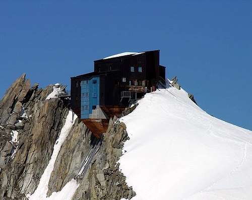
As it is quite impossible to do the traversee whithout sleeping somewhere on the route, a good idea is to make a reservation into the Refuge des Cosmiques (3617 m), which may be reached in around 30 minutes of easy glacier walk from the Aiguille du Midi. As it is a private hut of the French Glaciology Service, the prices are quite high. If you prefer to stay alone, you have the possibility to set up your tent on the Col du Midi, under the hut. Camping is allowed from arond 5 PM until 7 AM. (You normally have to dismantle your camp before leaving for the summit. You can let the tent there in its bag, no one will steal it, but you will have to come back here from the summit to recover it).
- Refuge des Cosmiques m. 3613 – C.A.F.
Accomodation in Chamonix
Chamonix is a primary destintion, offering several accomodations (hotels, huts, gites, renting rooms). Numberless campsites are situated both in the Northern and Southern ends of the town.
Main campsites:
- Camping Glacier d'Argentière - Argentière (8 km. North to Chamonix) +33(0)450541736
- Camping la Mer de Glace - Les Praz (3 km. North to Chamonix) +33(0)450534403
- Camping les Deux Glaciers - Les Bossons (3 km. South to Chamonix) +33(0)450531584
- Camping les Arolles - close to the centre of Chamonix - +33(0)450531430
- Camping les Cimes - Les Bossons (3 km. South to Chamonix) +33(0)450535893
- Camping les Marmottes - +33(0)450536124
When to climb
The best period goes from July to September
Meteo
Meteo Chamonix
Meteo Regione Valle d'Aosta
Useful information
- Office de la Haute Montagne de Chamonix Phone +33 0450 532208 Office de la Haute Montagne
- Cable-car informations Phone +33 0450 532275 Compagnie du MontBlanc
- Office du Tourisme de Chamonix Phone +33 0450 530024 Chamonix Mont-Blanc
Guidebooks and maps
Guidebooks

“Monte Bianco Vol. I” di Gino Buscaini, Collana Guide dei Monti d’Italia CAI TCI, 1994.
“Monte Bianco - Guide Vallot” ed. Mediterranee, 1999.
“Il massiccio del Monte Bianco – Le 100 più belle ascensioni” by Gaston Rébuffat, Zanichelli Edizioni
“Rifugi e Bivacchi delle Alpi Occidentali” by Cesare Re, Ed. Guide Macchione, 2005
“Rifugi e Bivacchi del CAI” by Franco Bo, Ed. Priuli e Verlucca, 2002
Maps
CNS 1:50000, Courmayeur, foglio 292
Kompass 1:50000, Monte Bianco, foglio 85
De Agostini 1:50000, Monte Bianco
nattfodd - Sep 2, 2009 1:54 pm - Hasn't voted
TopoI added three photos with the route marked, shot from different points in the climb (shoulder du Tacul, col de Brenva and the summit). You might want to add them in the main article next to the one shot from Aiguille du Midi.
gordonye - Jul 28, 2013 2:28 pm - Hasn't voted
My trip report July 6, 2013http://blog.travelpod.com/travel-blog-entries/gordon.ye/44/1373642642/tpod.html