
-
 8885 Hits
-
 78.27% Score
-
 9 Votes
|
|
Route |
|---|---|
|
|
48.49600°N / 113.415°W |
|
|
Hiking, Scrambling |
|
|
Summer, Fall |
|
|
A long day |
|
|
Class 3/GMS: III (3) LL |
|
|
Overview
This page was originally contributed by Aaron Johnson. The current page owner inherited the page when he decided to decrease his involvement in SummitPost.org. The text is unedited unless noted otherwise.
This route requires 12-14 hours to complete. The day may be longer if your party ascends the mighty horn of Flinsch Peak as well. Once you begin the ascent of the south face on Rising Wolf, there are no trails or cairn markers. Your route finding ability is essential to the successful execution of this obscure route.
This route is mentioned almost as an afterthought in "A Climber's Guide to Glacier National Park" by J. Gordon Edwards, regarded by most climbers as the bible to climbing in Glacier National Park. From that text: "Beginning from the streambed halfway along the north shore of the lake, it is an easy obvious scramble to the ridgetop far to the east of the summit, and a gentle walk up that ridge to the top." How one describes "obvious" and "easy" is up to the interpreter.
An alternate route is available and can be found in the second volume of Climb Glacier National Park written by the current page owner. It does not follow the route suggested below and is more direct. It can be ordered at Climb Glacier National Park
This route description is a considerable expansion upon this initial description, but keep in mind that route finding is required and your route choices may vary in difficulty from the description provided here. If possible, consider inquiring about the route with a member of the Glacier Mountaineering Society (GMS), or at least someone who has climbed the route before that can provide information or instruct you on the particulars concerning the route.
This route was originally contributed by Aaron Johnson.
TOTALS
GAIN: 4,500 feet
MILEAGE: 14 miles round trip
RATING: GMS III (3) LL
GMS Rating System

Getting There
From the north, take Hwy 89 south from Saint Mary, turning on Hwy 49—a paved road, but very winding and slow going; relax, enjoy the wonderful views!—for approximately eight miles until the Two Medicine turnoff, then it’s seven easy miles to the campground, ranger station, store, boat dock, and ample parking. From the south, take Hwy 2 to East Glacier, and in town turn on Hwy 49, head north out of town four miles, to the Two Medicine road.Standard Precautionary Note: All GNP roads are closed in winter, with Going-to-the-Sun Road (the major route through the park; its eastern terminus is at Saint Mary) sometimes not opening until July (average opening is second week in June; earliest opening ever is May 16th). Don't head out early in the year (i.e., June/early July) without checking the status of these roads—it is not unusual to have repeated, sometimes lengthy, road closures due to storms, avalanches, rock slides, or all three! The same holds true for late in the year; weather changes dramatically, beginning usually around the end of August, with road closures normally becoming more and more frequent through the month of September (although don’t shy away from going, there can also be very nice—albeit cool or cold—days of Indian Summer throughout this time frame; plus the park is relatively free of people after Labor Day). The following links are pretty much self-explanatory, and provide all sorts of useful and interesting information:
Map of Waterton/Glacier International Peace Park
Interesting photographs of the spring plowing on Going-to-the-Sun Road
Route Description

Climbing the Diorite Sill on the East Ridge of Rising Wolf Mountain
SOUTH FACE ASCENT
Depart the trailhead by crossing the bridge and going to your left. You will soon be walking along the north shore of Two Medicine Lake. If you are not paying attention, it will be easy to march right past the point from which you depart the trail.
At approximately 1.75 miles, a dry streambed will present itself in an inconspicuous manner. Depart the trail due north up this streambed, which would likely not be dry during the spring and early summer and present a much greater challenge in wet water obstacles.
At a point of your discretion, get out of the stream bed and ascend grassy slopes to the right of the drainage. Bushwhacking will be required but there is nothing serious involved. You'll wind up through trees and brush, 50-70 yards east of the drainage. The key is to parallel the drainage on the right as you gain altitude.
Trees and brush will grow thin and you'll gain altitude among clusters of krumholtz growing out of fine, packed red scree slopes. Steepness does not relent after crossing a side drainage emptying into the creek you are paralleling.
Above this crossing, the terrain is steeper and the brush and krumholtz get thicker. Bushwhacking and route finding are required. Branches and roots will make good hand and footholds. Ascend toward an escarpment of black rocks. Ascend to their base and then climb to the right to get up and around this formation. Steep bushwhacking and "bush climbing" are encountered.
Above the black rocks, vegetation finally relents and you'll enter the vast red slopes and cliffs of Rising Wolf's south face. Ascend and contour toward the drainage on your left (Class 2 or 3, depending on your route choices), climbing through brief bands of red rock and enter the gully when feasible. Ascending the gully on the left goes well, and a staircased exit gully leads you out of the drainage left to further scrambling up steep red scree and seemingly endless cliff bands of red rock.
Further up, the slope relents and more packed scree is encountered. Loose rock is abundant so step carefully if others are below you. The slope loses its angle and you are soon on top of the ridge, greeted by a stupendous view. Believe it or not, the summit is yet another 30-60 minutes away from this location.
Proceed west over a bump in the ridge, where more Class 3 climbing will be encountered, and then ascend the summit itself via a narrow ridge marked by the black volcanic rock of the Diorite Sill, a prominent geologic feature found throughout Glacier National Park.
Class 3 climbing is encountered on this ridge. Stay to the left and scramble up on tall steps of pleasantly solid lava. A steep snowfield lingers below this portion of the route, and below that are cliffs. Avoid the snow and be sure of every step you take through this section.
Beyond this fun scramble is the roomy summit where you can take a well deserved break. The view that rewards you is unparalleled and will be more than worth your effort.
Descending the South Face is a possibility if you are certain of your route finding abilities and you can safely retrace your steps. It is otherwise strongly recommended (as it is in the Climber's Guide by Gordon Edwards) that you descend by the rest of this route. DO NOT descend this mountain's east or south faces as many hidden cliffs are unseen from above.

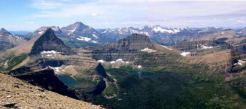
Dramatic descent of Rising Wolf's West Ridge traverses beneath Flinsch Peak
DESCENDING THE WEST RIDGE
This route follows Rising Wolf's long and spectacular west ridge over to Flinsch Peak and Dawson Pass and is certainly worth the time and effort.
Proceed west and descend from the summit down steep and lose talus. Some talus skiing and occasional scree sliding will be required. Angle slightly left to avoid the black cliffs of the diorite sill formation.
Dropping below the black cliffs, angle to your right toward the obvious ridge extending west toward the mighty Flinsch Peak. Once on the dramatic and broad ridge, you'll be on easier ground for much of the distance and it is a pleasant stroll among the great peaks of the Glacier high country. This is one impressive walk you will never forget.
The ridge eventually narrows to a buttress of rock that requires a down climb of about thirty feet (Class 4) but is not difficult with plenty of holds. An easier alternative is before the end of the buttress, where to your left is a gully that can be easily downclimbed (Class 3). Loose rock in this alcove is present, so descend with care, but this route is not dangerous for able climbers. Exiting the alcove at the bottom, a brief contour west rejoins the ridge proper, which is still narrow.
The route follows the ridge and then contours to the left on a narrow game trail. Cairns (or ducks) will mark the route, and soon the markers will lead you in a direct climb to regain 80 feet in elevation and the ridge top.
The ridge top continues west, encountering more towers of the blackened diorite sill, which are easily scrambled or bypassed on the left. Beyond this formation, the east ridge of Flinsch Peak rises in earnest. Your group may also choose to contour across the stable talus slopes of Flinsch Peak as well, at first staying as high as possible to avoid krumholtz bushwhacking lurking below.
Eventually you will encounter a long string of krumholtz running down the slope. Look sharp for a weakness through which you will easily pass. Good route finding will keep bushwhacking to a minimum and not far below will be the trail to Dawson Pass. Finding a passage through the krumholtz is key to saving some distance that must otherwise be covered to reach the trail near Dawson Pass. Be certain not to descend too soon, as the krumholtz gets very thick and you may not see cliffs lurking within it just above the trail!
Once on the Dawson Pass trail, it will likely be late in the day and you'll need to high tail it out of there. It is bear country, so make noise regularly during your brisk march out of the area. The trail is good all the way back to the camp ground, so a steady march can consume the 7 miles in around 2 hours.
Ascending the West Ridge from Dawson Pass is covered in detail in the highly recommended Glacier Climbing Guide by Gordon Edwards.
Essential Gear
SPRING: A full compliment of winter gear, including ice axe, helmet, screws and snow boots are required. Avalanche danger on the south face will be considerable through most of the spring.SUMMER AND FALL: Standard dayhike gear will do. Be sure your boots are in good condition for the large amount of climbing that is required on this route. Headlamps or flashlights are also recommended.