
|
|
Route |
|---|---|
|
|
53.10629°N / 4.00383°W |
|
|
Scrambling |
|
|
Spring, Summer, Fall, Winter |
|
|
Half a day |
|
|
Scrambling to grade I |
|
|
Overview
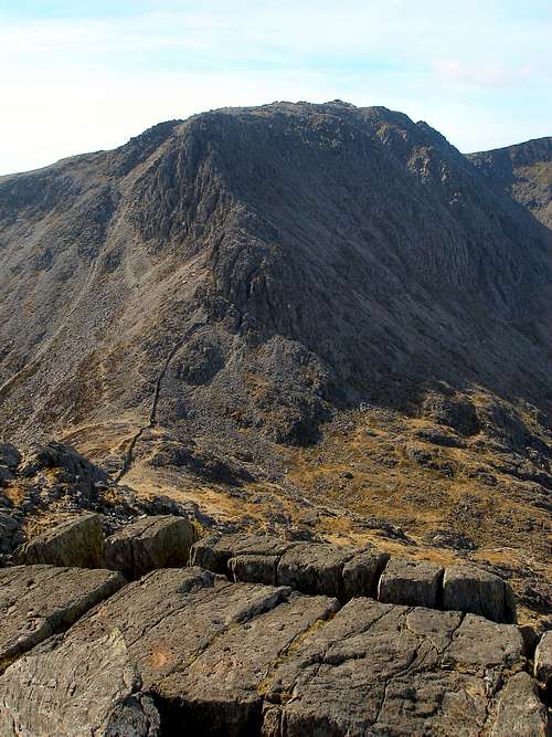
This famous ridge defines the broad northern face of Glyder Fach, connecting its summit with that of Tryfan via Bwlch Tryfan. The ridge is a superb scramble in its own right, however it is usually incorporated into a horseshoe, which traverses the summits of Tryfan's North and South Ridges and descends via Y Gribin. Of the many possible lines that ascend these rocky cliffs, this scramble takes a direct route that is nowhere excessively difficult and is both hugely enjoyable and rewarding. The rock, although polished, is always sound although care is needed in the lower sections of the climb as, in places, there is an abundance of loose scree. |
Getting There
 Exposed scrambling on top of the Great Pinnacle (this is optional) Exposed scrambling on top of the Great Pinnacle (this is optional)If approaching from the north or west, e.g. from Liverpool or Hollyhead, turn off the A55 and onto the A5 at the large junction (SH 593 694) that sign posts for Bethesda and follow the road until Llyn Ogwen where parking is available. If coming from the east, take the A5 through Bettws y Coed (SH798 599) and Capel Curig (SH 719 580) which will take you directly to the base of the mountain. If driving from the south, take the A470 through Blaenau Ffestiniog (SH 700 458) to Bettws y Coed, and turn off onto the A5 towards Bethesda which will take you the same way as if coming from the east. There is plenty of parking along the A5 near Tryfan, some of which you have to pay for, some of which you don't. My advice is to never bother with the official car parks and just park along the roadside. There is a wide 'pavement' type verge on the southern side of the road that can easily accommodate the width of a car or minibus, and is completely free and never full (even on bank holidays). It also allows you to park even closer to the base of the mountain and the start of the path. |
Route Description
The Approach The approach can start anywhere along the A5, however for the sake of clarity I shall use Idwal Cottage (SH 649 604) as the starting point. The route takes the path around the rear of the toilet block and then after a few metres forks left, and crosses a stile and a footbridge onto a stone track. The route diverges from the path where is curves around to the right towards Cwm Idwal. It ascends leftwards over marshy terrain and joins a steep path on the west bank of a stream to Llyn Bochlwyd. The route crosses the stream overflow and follows the path to Bwlch Tryfan. The Route To begin with the route follows the stone wall to the base of the ridge. From the foot of the lowest crags it goes 10m right and ascends a short gully, existing left over another wall to the foot of the imposing sinister gully. Some careful scrambling is required here detouring onto the left wall where it steepens and then escaped onto easier ground. There is quite a lot of loose rock in the gullies and care is needed in order to avoid dropping large stones on anyone climbing below you. 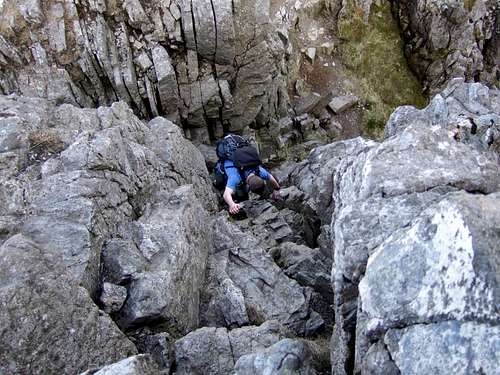 Gully scrambling in the lower section of the route Gully scrambling in the lower section of the routeThe route continues up a slabby shoulder and onto an increasingly narrow ridge, goes over a small pinnacle followed by a second lager one and then descends into the prominent notch of Great Pinnacle Gap. It then escapes up a short wall just right of the slender Great Pinnacle (stop and get a picture of yourself on the pinnacle, the exposure is awesome), and then passes through a gap between a small pinnacle and the main body of the ridge to reach easier ground. An elevated boulder pavement leads onto the summit plateau. The route then goes south-west to join the normal route up Glyder Fach and follows a path to the summit tor. |
Essential Gear
During the summer you will need all the equipment you would normally use on a Grade 1 scramble i.e. a good pair of boots and full waterproofs. A rope and helmet may be required for the inexperienced or those without a head for heights. If your lucky enough to climb this route in winter conditions then and two ice tools, crampons, a helmet, a rope and a winter rack are all essential. |
Maps
|
| Navigation Maps OS 1:25k Explorer Series OL 17 Snowdon/Yr Wyddfa OS 1:50k Landranger Series 115 Snowdon/Yr Wyddfa Harvey Map Services 1:25k: Snowdonia North: Snowdon, Glyders, Carnedds Harvey Map Services/BMC 1: 40k British Mountain Map: Snowdonia North Road Maps |
Guidebooks
External Links
 Bristly Ridge from Tryfan Bristly Ridge from TryfanGovernment Bodies and Official Organisations Snowdonia National Park Authority Association of National Park Authorities Royal Commission on Ancient & Historical Monuments in Wales Hiking, Climbing and Mountaineering Organisations and Companies British Mountaineering Council Plas y Brenin National Mountain Centre Weather Tourist Information North Wales Tourism Partnership Local Information from Gwynedd.com Local Information from Snowdonia Wales Net Travel Welsh Public Transport Information Accommodation Youth Hostel Association in Wales Maps and Guidebooks Cordee Travel and Adventure Sports Bookshop Wildlife and Conservation |