
|
|
Route |
|---|---|
|
|
34.19700°N / 117.53°W |
|
|
Hiking |
|
|
Fall |
|
|
Half a day |
|
|
Class 1B (for brush) |
|
|
Overview
Until a couple of years ago, the principal route to visit the San Sevaine-Buck Point ridge area was Forest Road 1N34. Now that it's closed to motor vehicles due to storm damage and fires, visitors must hike 9 miles to gain access. An alternative route that shortens access to 1N34 by at least half is the south ridge that starts at the end of Etiwanda Ave in Rancho Cucamonga. The route up the ridge is primarily an overgrown fire break that drops you onto 1N34 just east of Buck Point. From this spot, you can access a number of HPS peaks including San Sevaine Lookout, Buck Point, Etiwanda Peak, and Cucamonga Peak. Joe Elliot Tree Memorial and campground are also accessed via 1N34 west of the top of the ridge.One way mileage from the ridge top parking area to 1N34 is 3 miles with 3700 feet of gain. From the paved end of Etiwanda Ave (rough location of the locked gate), add an additional 1.5 miles and 600 feet.
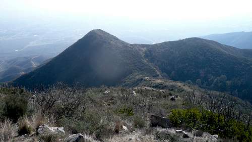 Along the ridge looking down at an intermediate bump
Getting There
The route is approached via Etiwanda Avenue in the City of Rancho Cucamonga. To get to Etiwanda Ave, exit the I-210 freeway at Day Creek Blvd (one off-ramp west of the I-210 / I-15 interchange) and turn north. Follow Day Creek Blvd first north and then east until it dead ends at Etiwanda Ave. Turn left and drive ¼ mile north until the road ends at a locked gate. Depending on your vehicle, there are apparently a number of side roads that circumvent the locked gate. Proceed up the dirt road as it heads up East Etiwanda Canyon. At the nature habitat sign (4-way junction), take the left fork as it climbs onto the ridge. The wide, cleared area on top of the ridge is the beginning of the route. In the embedded map below, the ridge top parking can be seen about an inch to the right of the minus sign in the zoom tool.View Larger Map
Route Description
The route is fairly straight forward as you just follow the fire break up the ridge. The brush starts as you’re descending the first intermediate high point but the use trail hugs the west side of the saddle and avoids almost all of it. Continue up the center of the ridge (except for one short section of Manzanita) until you hit a rocky headwall. The fire break actually veers west (left) around this portion of the ridge. Follow the over grown “road” until it ends and then head straight up avoiding the worst of the brush. Pay attention as you proceed on the overgrown use trail through the brush for the return trip. It is easy to get off track on the way back and find yourself in the midst of solid, chest high white thorn bushes. After the brush thins, you’re basically on top of the ridge and about 10 minutes finds you at 1N34. Buck Point is immediately to your left (west) and San Sevaine Flats is a little over a mile to your right. Joe Elliot Tree Memorial campground is reached by following 1N34 west about 2 miles; this is also the beginning of the Joe Elliot trail to Etiwanda and Cucamonga Peaks.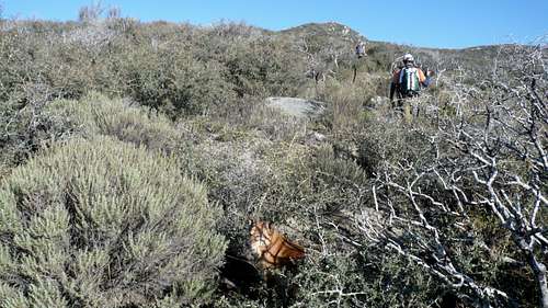 Can anyone say brush?
Essential Gear
Long pants unless you believe in self torture like I do.