
|
|
Route |
|---|---|
|
|
40.76360°N / 107.05757°W |
|
|
Hiking, Mountaineering, Scrambling, Skiing |
|
|
Summer |
|
|
Half a day |
|
|
Overview
Perhaps the easiest route up the mountain from the east is to follow Trail #1175 from the end of FR 480A before leaving the trail and scrambling to the pass between Sand Mountain and Meaden Peak East and then north to the top. This route is short and steep, gaining over 1500 feet in a short amount of time. There is a more direct route, but it appears to have more loose scree and is not recommended. Meaden Peak East as seen from the south and from the north ridge of Sand Mountain.
Getting There
VIA STEAMBOAT SPRINGSOption #1, East Loop:
From Steamboat Springs, drive to the north end of town and to where County Road 129 leaves Highway 40. A sign marks "Clark" and "Hahns Peak". This is the same road heading to the airport. Drive north on CR 129 for approximately 26 miles. Pass Steamboat Lake and turn left on County Road 62. Drive County Road 62 west and south for about 3.5 miles to FR 42 on the right. Turn right on FR 42 and drive for 0.6 miles to the forest service gate. This gate is locked until July 1st each year. Drive County Road 42 for 1.5 miles to where FR 480 (east loop) takes off to the left. The road here is bumpy, but still passable to 2wd’s if you go slowly. Turn left on to FR 480 which is a very rough 4wd road. Before driving this road, make sure you have a competent 4wd. We witnessed a grouse hunter damage his Dodge Durango on this road, so use caution. Follow the rough FR 480 for 3.3 miles to where the better road 480A turns left. Follow 480A for 0.5 miles to its end. This is the trailhead.
Option #2, West Loop:
If you don’t have a 4wd, and if you want to minimize road walking, you may want to choose this option. From the Junction of County Road 42 and FR 480 (east loop), continue straight along County Road 42 and follow the bumpy road for another ~3.7 miles. The west loop of FR 480 takes off to the left. Park here if you have a 2wd, or follow FR 480 left for 0.4 miles to 480B. To reach the trailhead at 480A, continue on FR 480 for another 0.8 miles to the junction of FR 480A. Turn right on 480A and follow it 0.5 miles to the trailhead.
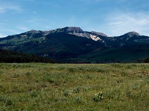 Sand Mountain (left) and Meaden Peak East (right) as viewed from the Southeast on July 26 2008.
VIA HAYDEN
From Walnut Street in Hayden, turn north on Walnut, a.k.a. County Road 76, and follow it north for 0.7 miles to County Road 80. Turn right on (gravel) County Road 80 and follow it for 27.3 miles to FR 42. Turn right on FR 42. The first 2.5 miles of FR 2.5 are pretty good, but it quickly turns into a 4wd road after that. The rough section last for 1.4 miles and ends at a saddle. Continue straight at the saddle (instead of heading left), and follow FR 42 for another 0.8 miles. At this point, FR 480-West Loop takes off to the right. See the above paragraph for directions to the trailhead from here.
Route Description
From the trailhead, follow the trail uphill and to the south. Almost immediately, there are several fallen trees to climb over or to walk around. There is a side track taking off to the right a short distance from the trailhead. Ignore it and stay left on the main trail.Your objective will be a small stream crossing which is not too far from the trailhead. From the stream crossing (which may dry up in late summer in a drought year), follow the stream uphill and to the southwest. The next objective is the prominent saddle between Sand Mountain and Meaden Peak East, so make your way up through the forest and slopes to the saddle. From the saddle, the peak is visible to the northwest and is a steep scramble to the top. Make sure to avoid the erosion prone slopes and stay as much as possible on the stable vegetation as much traffic (presently the peak sees almost no traffic) could cause erosion. (If climbing the peak in winter, this slope can be avalanche prone, so make sure to vary the route by staying in the trees more).
There are about 4 bumps on the summit ridge and the one that is the westernmost seems to be the highest.
Enjoy the fine views from the summit. To the east are Hahns Peak, Steamboat Lake and the Mount Zirkel Wilderness Area. To the south is the Sand Mountain and Steamboat Springs area. To the west are the Elkhead Mountains, and you can view most of the major summits. To the north is Wyoming and the very interesting-looking Nipple Peak.
The round trip distance from the end of the 4wd road is about 3 miles with about 1500 feet elevation gain. If you don't have a 4wd, the hike is much longer.
 Meaden Peak East as seen from the south and from the north ridge of Sand Mountain.