
|
|
Route |
|---|---|
|
|
47.79189°N / 121.19826°W |
|
|
Hiking |
|
|
Spring, Summer, Fall, Winter |
|
|
Half a day |
|
|
Moderate |
|
|
Overview
Johnson Ridge Trail #1067 is the most accessible route to the summits of Sunrise Mountain and Scorpion Mountain, two alpine peaks located in the Wild Sky Wilderness of Washington State. The route is also an excellent training hike for amateur hikers. The trail is 4.8 miles long, running west-to-east and ending at Joan Lake. This route is well-groomed and easy to follow. Roundtrip, it is recommended to allow 5-7 hours to complete this hike.The U.S. Forest Service lists this route as having a moderate-to-high level of difficulty. The elevation gain from its lowest point (3600') to its highest point (5400') is only 1800'. However, the hilly terrain of Johnson Ridge makes the cumulative elevation gain much greater. In example, the trail climbs 1400' in the first two miles, from the trailhead to the summit of Sunrise Mountain, then immediately descends several hundred feet on a steep slope.
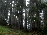
Johnson Ridge Trail #1067 traverses across typical terrain found in Wild Sky Wilderness. The trail crosses formerly logged areas, dense old-growth and second-growth evergreen forests, and sub-alpine meadows. The thick forests limit far-ranging views, but there are enough open areas along the route to provide decent views of nearby peaks in Wild Sky Wilderness.
Route Description

The trailhead of Johnson Ridge Trail #1067 has a starting elevation of 3600'. The first mile switchbacks, and steadily gains elevation, through an abandoned logging area on the western edge of Johnson Ridge. After the first mile, the trail begins traversing through a dense old-growth and second-growth Douglas fir forest, marking the route's entrance into Wild Sky Wilderness.
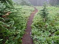
The second mile of the route traverses through forest, still steadily gaining elevation. After climbing up the upper western slope of Sunrise Mountain, the trail levels near the summit (5056'). There is a sub-alpine meadow of huckleberries, heather, and stunted trees surrounding the summit area. The actual summit is in an open area to the right of the trail. The open area of the summit provides a great place to take photos and have a snack. On clear days, there are great views of the Rapid River Valley to the north.
After passing the summit of Sunrise Mountain, the route steeply descends several hundred feet before beginning to gradually re-ascend along the top of Johnson Ridge. Between Sunrise Mountain and Scorpion Mountain, the trail traverses through several ridgetop sub-alpine meadows and forested areas. One or two old spur (fisherman's) trails might appear along this stretch of the route, heading south, but DO NOT use any of these spurs. Johnson Ridge Trail #1067 keeps following along the top of the ridgeline.

After approximately 4.4 miles from the trailhead, Johnson Ridge Trail #1067 reaches its highest point at 5400' elevation. Shortly thereafter, the trail begins to gradually descend eastward along the meadow-filled southern side of Scorpion Mountain. If the desire is to reach the summit of Scorpion Mountain, at this point where Johnson Ridge Trail #1067 begins to descend along the meadow-filled slope, there is an old spur to the left which follows the north side of the ridgeline. This spur route leads to the summit of Scorpion Mountain (5540'), approximately 0.2 miles further and 140' higher than Johnson Ridge Trail #1067. The spur trail then rejoins Johnson Ridge Trail #1067 on the southeastern corner of the peak.
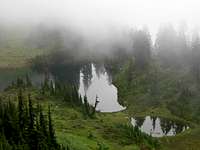
After passing by Scorpion Mountain, Johnson Ridge Trail #1067 then leads to nearby Joan Lake, crossing into Henry M. Jackson Wilderness area. From the highest point along Johnson Ridge Trail #1067, at 5400', the lake is approximately 0.4 miles further along the main trail or 0.7 miles further if the spur trail to the summit of Scorpion Mountain is included. After passing the upper southern slope of Scorpion Mountain, Johnson Ridge Trail #1067 gradually descends through a sub-alpine meadow along the top of the southeastern slope before entering a steeply sloped tree-covered area. This is final slope down to Joan Lake. Use extra caution if the ground is wet or snow-covered, as this section of the route can become very slippery. The trail faintly ends at the southern marshy meadow end of tiny Joan Lake, at 5000' elevation.
Getting There
Driving directions for Johnson Ridge Trail #1067:1) Drive Highway 2 to Beckler River Road (also known as Forest Road 65).
This intersection is approximately 1/2-mile east of Skykomish and 1/2-mile west of the Skykomish Ranger Station.
2) Head north on Beckler River Road/ Forest Road 65. Follow for approximately seven miles.
3) Turn right (u-turn) onto Forest Road #6520.
This intersection is at an open area on the rightside of the road, just prior to the one-way bridge crossing Rapid River.
NOTE: Forest Road #6530 is also at this intersection (but follows Rapid River upstream), while Forest Road #6520 is a right u-turn (heading uphill).
4) Follow Forest Road #6520 for seven miles to the trailhead for Johnson Ridge.
Essential Gear
No essential gear needed.Red Tape
A Northwest Forest Pass (parking permit) is required. A Northwest Forest Pass can be purchased from the Skykomish Ranger Station or any REI store in Washington State. A day-use pass costs $5; an annual pass costs $30.-> UPDATE: According to local peakbagger Eric Willhite during 2012, all signs stating the requirement of the Northwest Forest Pass have been removed.
There is a register at the trailhead. The Forest Service requests all visitors of Johnson Ridge Trail #1067 to register before traveling on the route.