
-
 2990 Hits
-
 71.06% Score
-
 1 Votes
|
|
Route |
|---|---|
|
|
35.16400°N / 106.4165°W |
|
|
Hiking |
|
|
Spring, Summer, Fall |
|
|
Half a day |
|
|
Class 1 |
|
|
Facts
Distance - 4.4 miles (one-way)Trailhead Elevation - 6440'
Summit Elevation - 9579'
Gain - 3140'
Approach
See the "Getting There" section for the Pino Route on the Point 9579 main page.Route Description
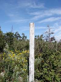 The marker for the intersection with the Crest Trail
This trail begins in the Ellena Gallegos area where there are many trails. Be sure to follow the Pino trail due east. None of the other trails climb very far into the mountains. At times this trail can become rather steep and rocky but never really gets beyond a Class 1 trail. After 4 miles you will reach the Crest Trail which sits at about 9,280ft so at this point there is not much further to go. Head south on the Crest Trail for about 0.3 miles. Here is where you will leave the trail and head directly west for the summit with only 0.1 miles to go. The brush and trees are not too dense so bushwhacking and route finding are not difficult. At this point having a GPS with the summit coordinates entered would be helpful.
Essential Gear
Typical gear for a short hike. A GPS would be helpful for the final section of route finding.External Links
Local weather: AlbuquerqueCibola National Forest - Sandia Ranger District
Local Search and Resuce Team: Cibola SAR