
|
|
Route |
|---|---|
|
|
3.17193°N / 98.39077°E |
|
|
Hiking, Scrambling |
|
|
Spring, Summer, Fall, Winter |
|
|
Most of a day |
|
|
Grade 1 Scrambling |
|
|
Overview
The route from Lake Kawar is the normal route of ascent. The climb involves 1000m of ascent and requires typically 6-8 hours. The initial path can be difficult to find but once on it the path is well trodden. Some people hire a guide, either at the lake or at one of the Berastagi guesthouses, however if you follow the description below and are confident enough with easy scrambling then there should be no need. The climb is a great day’s activity as the volcano’s flora is beautiful, as are the views, and the ascent varied with plenty of interest. Compared to Sibayak, you’ll likely have the volcano to yourself.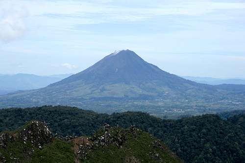 Gunung Sinabung from neighbouring Gunung Sibayak
Getting There
 Lake Kawar
From Berastagi there are opelets (small minivans with two benches in the rear for passengers) to Lake Kawar that leave throughout the day. The yard that they depart from is on the Northern side of the bus station but just ask bus companies and you will be pointed in the right direction. The journey to the Lake is only 24km although how long this takes depends on how many deliveries the driver has to do and detours are not uncommon.
Route Description
From Lake Kawar follow the path that leads to the pavilion on the hillside below the volcano. There is a sign for Gunung Sinabung in the village but it point 45 degrees the wrong way and will send you up the wrong path into vegetable patches if you follow it.The path climbs diagonally towards the pavilion, passes beneath it and then quickly arrives at a broad crossroads. Turn right up the wide track that gently climbs through fields of tomato and chilli plants.
Follow this path for 5 minutes until the first trees appear on you left hand side. The path up the volcano begins by the first tree. It’s easy to miss as initially narrow as the path’s entrance is overgrown. If you miss it then you will follow the track for another 5 minutes through more vegetable crops until it stops at the edge of the forest. The photos below show the start of the path that you are looking for.
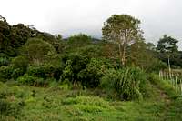 First tree on the left marks the start of the trailhead First tree on the left marks the start of the trailhead |
 The trailhead The trailhead |
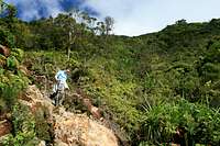
 Typical terain through the forest
Follow the path that leads directly towards the forest edge ducking under overgrowth in a couple of places. After a hundred metres or so the path quality improves and bears right to loosely follow the edge of the farmers’ crops. Weaving back and forth the route soon enters the forest proper and begins to climb more steeply in the direction of the volcano.
The path is stepped with numerous exposed tree routes that weave back and forth. In paces the path is eroded and some sections require easy scrambling. Often it is muddy but despite this it is a fun climb, and always under cool, pristine forest cover.
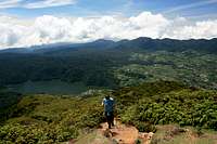
After approximately 700m of ascent the tree cover subsides and is replaced by low bush and bracken. Views back to Lake Kawar and across to the edge of the Gunung Leuser National Park to the West open up. The route from here on climbs a narrow streak of lava flow and requires grade 1 scrambling for the large part. There are plenty of foot and handholds in the lava however difficulties would naturally increase in wet conditions.
 Descending the lava flow Descending the lava flow |
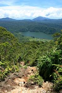 View to Lake Kawar from lava flow View to Lake Kawar from lava flow |
 Descending the lava flow Descending the lava flow |
A short distance below the summit the lava flow subsides and by this time the flora resembles something of Southern England rather than Indonesia.
Views from the summit are amazing although sometimes obscured by cloud. The summit crater is also a dramatic landscape. Besides the main summit there are two subsidiary summits that are worth climbing further great views.
Descend by the same route.
 View South-East View South-East |
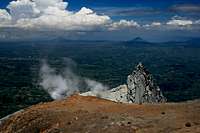 View South View South |
 View South-West View South-West |
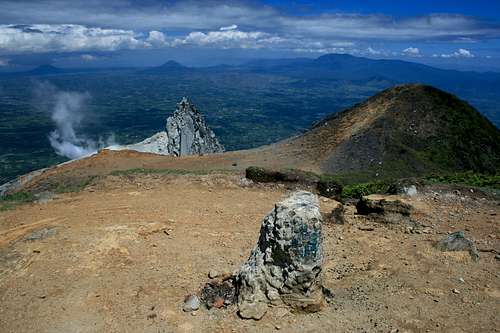 Gunung Sinabung's summit
 Summit plateau Summit plateau |
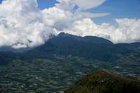 View to Gunung Sibayak View to Gunung Sibayak |
 View North to Lake Kawar View North to Lake Kawar |
Essential Gear
- Light waterproof jacket- Good walking shoes that you don’t mind getting muddy
- Mosquito repellent
- Tent if camping at Lake Kawar