
-
 6210 Hits
-
 73.06% Score
-
 3 Votes
|
|
Route |
|---|---|
|
|
46.35777°N / 14.53423°E |
|
|
Hiking, Via Ferrata |
|
|
Summer, Fall |
|
|
Medium hard hihe, easy ferrata |
|
|
Overview
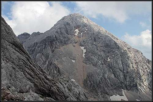
Grintovec from the W - from Špremova pot
The ridge from Kočna to Grintovec has low walls on the southern side and high ones on the northern side. The valley Dolci comes from the south almost to the top of the ridge, there goes also a possible approach. The lowest point of the ridge is Zdolška škrbina (notch), named after Suhadolnik (in the local dialect 'Zdounk') farmer on the southern side. The normal passage over the notch itself is not possible (there are climbing routes), but a little higher, towards Kočna, from the northern side Kremžar route (ferrata) comes up, and the approach from the south is also marked. This will be the starting point where our description of the route towards Grintovec begins.
The western ascent route on Grintovec is named also Špremova pot (route). On a few parts it is secured and the passage below Grintovec summit is exposed, so the route is not suitable for people suffering from vertigo. Scrambling and hiking also requires some care on sections which are not secured.
Getting There
For the trailheads in the valleys, see the main page of Kočna. That is either Jezersko on the north or Suhadolnik farm on the south. In any case you have some 3-4 hours to reach the Hočna-Grintovec ridge.Route Description

Below the entry into Grintovec's W face

The towers below Zdolška škrbina (notch)
Entering the W face of Grintovec, the path is winding up in the vicinity of a distinct scree slope, which above ends in a steep, rugged ravine. The ravine itself does not offer a good passage in summer, but in winter, if somebody decides to ski down from the summit of Grintovec into Dolci valley (alpinistic ski tour), finding a passage into that ravine is the only possibility. Our path goes by the left side of the scree slope, avoiding it wherever possible in the nearby rocks. The path is weak, quite steep and not very pleasant, but we get altitude quickly. Above we approach the ravine again, but close to its upper part the route switches towards the left. In a few turns it gets up over the rocks (cables for protection) and then goes left, just above the big abysses of Grintovec's north wall. A narrow ledge is well secured (cable), but exposed. Now we understand clearly why in winter skiing by this route is not possible.
After some 30 meters the ledge exits on the northern screes of Grintovec. That is the small 'roof'-like slope, which is so nicely seen from Jezersko. The path is going up and across the screes, unpleasant and tiresome in a few places. In the middle of the scree slope thete is the crossroads. Continuing (and descending later) is the path from Grintovec on Mlinarsko sedlo (saddle). To ascend the summit of Grintovec we must turn right and start ascending the scree slope more steeply. Some good 100 meters more to go. Just below the summit the scree slope ends and we must climb over a few rocks. That part is protected again. It's funny how in 2009 one peg only was missing and suddenly the passage required some additional skill and power to come over.
The passage Kočna - Grintovec requires altogether 1h 45min. The ascent from the point where Kremžar route exits on the ridge would require good 1h 15min. The whole ascent from Jezersko (lower station of material cable way) would require good 5h and from Suhadolnik farm 5h 30min.