
|
|
Route |
|---|---|
|
|
46.55030°N / 9.06106°E |
|
|
Mountaineering, Trad Climbing |
|
|
Spring, Summer, Fall |
|
|
Most of a day |
|
|
5c |
|
|
5.8 (YDS) |
|
|
11 |
|
|
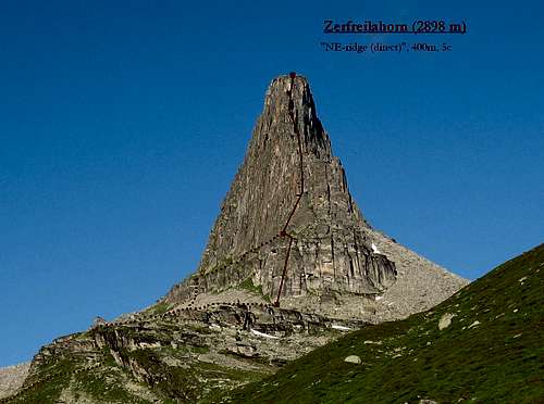
Overview
The Northeast Ridge of Zerfreilahorn is a classic rock climb in the Valservalley. The route is located on one of the most striking mountains in Switzerland, the Zerfreilahorn (2898 m). Despite the fact that the route is re-bolted it is still an alpine undertaking. A retreat will be very difficult and dangerous, especially from the upper pitches. Though the grade maybe doesn't look very challenging you'll still need to be able to climb solid on Gneis. If you look at the mountain than you might don't expect a real ridge climb, which is true for the first part of the route. But, the second half does go along the NE-ridge. Overall you don't have the feeling of a real ridge climb, but that doesn't makes it less worth climbing.The ridge is really worth climbing because it offers very raw granite like rock, which makes the climbing pretty technical. The route has bolted belays, and some bolts on the more difficult pitches. But most of the time you'll need to place your own protection, which is rather easy. The direct start is for those who would like to add two more challeging pitches. Overall the route is a little hard for it's grade, especially the last pitch.
First ascent: Ruedi and Werner Vieli, 1960
| "We were just armed with a newly purchased nylon rope, 5 pitons, 1 tube and 1 wooden wedge. This way equipped, we conquered pitch after pitch. Even the tube and the wooden wedge, were helpfull on our climb. The mobilization of all our forces finally succeeded in overcoming the last heavy pitch." | Ruedi and Werner Vieli, 1960 |

Getting There
To the Valservalley (Vals)Vals lies at the end of a side valley in the Surselva area (Bündner Oberland). Vals is located in the middle of the Alps, or to put it simply: it lies between Milan and Zürich (Zürich – Vals 170 km).
By car: Autobahn (A 13 Chur - San Bernardino), take the Reichenau - Flims exit. Follow Flims – Laax to Ilanz, turn off towards the Vals Valley [Valsertal]. Follow the twisting road to Vals. 60km from Chur to Vals.
By public transport: Ilanz has the nearest trainstation. It is located on the Chur - Oberalppass connection of the Rhätische Bahn. From Ilanz there is a Postbus connection to Vals, which runs quite often.
To the Zerfreilasee (Chappeli - 1900 m)
You can easily reach the Zervreila Restaurant by car and bus. It lies 8 km above Vals (1840 m) along the road the the Zerfreilasee. From the Restaurant you can drive for about 5 minutes to Chappeli where the road ends. It has a small Chapel and a parking. It also possible to take the Zervreila Shuttle bus.
To the Lampertschalp and the Läntahütte
From the parking at Chappeli it is possible to approach the Lampertschalp and Läntahütte. Follow the wide track pass the Zerfreilasee and cross the Kanalbrigde. Reach the Lampertschalp shortly after you've finished walking pass the lake. About 1.5 hours. From here follow a well marked path to the Läntahütte, about 2.5 hours from the Chappeli.
To the start of the route
The approach from Chappeli (1900 m) is probably most common. Follow the wide track pass the Zerfreilasee and cross the Kanalbrigde. Take the path up (direction Furggelti) after crossing a small stream. Follow this marked path untill the angle of the slope decreases. Cross the Hornbach at about 2200 meters and scramble your way up to the base of the mountain (slightly left). Choose the direct start or the original line. For the original line you'll have to climb through a gully and traverse right on the grassy ledges.


Route Description
There are two possible routes on the NE-Ridge, the original line and the direct line. The route is not very hard to find because there are some bolts that show you the way, or the line is pretty obvious. The last pitch is the crux!Original route: NE-Ridge, 345m, 5b (4b obligatoire/obligatory)
11 Pitches: 2a, 4b, 4c, 4c, 4a, 4b, 2a, 5b, 4a, 2a, 5b.
Some pitches can be linked together, but this might lead to some problems with the rope. (to much zick-zack).
Direct start: NE-Ridge Direct, 400m, 5c (5c obligatoire/obligatory)
13 Pitches: 5c, 5c, from here you catch up with the original route.
Descent: there are basically three possiblities.
1. Rappel down the rappeling route, which is bolted for 50 meters rope (25 meters between the belays). And starts just east of the end of the route.
2. Rappel down the route 'Nanouk'. This is only possible with a double rope of at least 50 meters. Because this route is pretty steep, it rappels fast and easy.
3. Continue by traversing the Zerfreilahorn.

Essential Gear, Maps and Guidebooks
Essential Gear: helmet, climbing shoes, a small rack of nuts, a few cams, 10 quickdrawns and at least a 50 meter rope.Unfortunatly the Zerfreilahorn lies on the intersection of three SAC-maps. Choose the map which suites your approach and climb!
Map 1:25 000:
- SAC Map: 1234 Vals
- SAC Map: 1253 Olivone
- SAC Map: 1254 Hinterrhein
- SAC Map: 266 Valle Leventina
- SAC Map: 267 San Bernardino
- SAC Map: 257 Safiental
Online Maps:
Guidebook:
- Guidebook Climbing Valsertal, Michael Illien, ISBN 978-3-936740-22-6
- SAC Guidebook: Bündner Alpen 2, Manfred Hunziker, ISBN 978-3859021549
- Plaisir OST, Jürg von Känel, ISBN 3-906087-28-X
To order SAC Maps: www.toposhop.ch
To order SAC Guidebook: www.sac-cas.ch
To order Plaisir OST: www.filidor.ch
To order the Valsertal Guidebook: www.panico.de
External Links
Läntahütte SAC 2090mThomas Meier
Haus Bellavista
CH-7132 Vals
Phone (hut): +41 (0)81 935 17 13
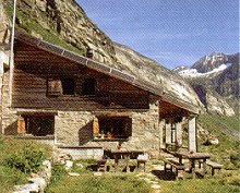
Homepage:www.laenta.ch/
Other useful links:
WSL Institute for Snow and Avalanche Research SLF - Avalance Bulletin
Vals / Valsertal - Information about the village Vals
Läntaclimb - News about climbing in the Valservalley area
Weather Forecast - Weather Forecast for Vals
Weather Forecast - Detailed weather forecast
Railroad information - Railroad schedule
Bus information - Postbus schedule
Zervreila Restaurant - Zervreila Restaurant
Trip report - Climbing the NE-ridge