
-
 5659 Hits
-
 79.04% Score
-
 10 Votes
|
|
Route |
|---|---|
|
|
52.28916°N / 117.47818°W |
|
|
Mountaineering |
|
|
Summer |
|
|
A few days |
|
|
II |
|
|
Overview/Approach

The north ridge of Mount Woolley was first climbed in 1948, some twenty plus years after the same Japanese team who made Mount Alberta’s summit planted their flag on Mount Woolley’s summit via its south face (1925). These are the only two routes published as of 2010 for Mount Woolley, one of the coveted 11,000’ers in the Canadian Rockies.
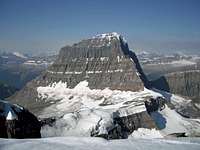


The north ridge of Mount Woolley can be accessed directly via the typical descent route for Diadem Peak or more classically by adding a summit bid to the southeast face ascent of Diadem Peak, making for two 11,000’ summits in one day. The latter can be done by descending Diadem’s south ridge to the col and then ascending the north ridge of Mount Woolley. The descent is a return to the col and then utilizing the traditional descent for Diadem Peak. The climbing involves fairly easy snow/ice travel avoiding a typically fully corniced summit ridge on the left. One steep snow/ice step is encountered along the way. The view from the summit puts you square with the infamous east face of Mount Alberta (Japenese Route) along with an exceptional view of the North and South Twins.
Drive north on the Icefield Parkway approximately 12km from the Columbia Icefield Visitor Center. Park at a large pull out on the right side of the road. Cross the road and ford the glacier fed Sunwapta River. I prefer to bring extra shorts, neoprene booties and tennis shoes that I end up leaving on the other side for the return. Poles are quite helpful as this crossing can be waist deep in spots. Angle northwest towards an obvious canyon entrance (Woolley Creek).
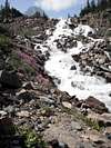
Find a trail just south of this entrance that immediately rises above Woolley Creek on the left which passes above an incredible hidden waterfall. Follow the trail into the upper creek and follow the intermittent washed out trail (sometimes on the bank through the brush, sometimes skipping rocks) along the creek until you reach a huge boulder field. Take a center break through this area, tediously hopping large boulders and scree until you reach a headwater junction. Crossing the rapids on the left can be the crux of your trip via your approach or return depending on the time of day and just how warm (glacier melt) it gets. There should be cairns (2010) directing you to at least two possibilities, both can be unnerving if the water is high. Once on the other side of this left fork drainage, continue along the right fork on the left side via a decent trail that gains elevation as it follows Woolley Creek to its origin at the base of Woolley and Diadem’s glacier and icefall. This is the bivy site for the common routes on these two objectives.
Route Description
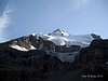
This is a 6500'+/- accumulated ascent trip.From the bivy site at the east end of the tarn, head west for the glacier. After crossing several braided drainages of the toe (can and likely will be quite higher on return), start ascending the ice to the north of these water flows. Stay between the deep crevasses and voids on either side of the glacier heading the direction of the large ice fall. Ascend the snow couloir to the right of this enormous ice fall. A rock headwall divides the couloir from the icefall. There are two snow couloirs, only one typically reaches down to the glacier and it is to the right. The one on the left is used for part of the descent. However, try not to get confused and mistake it for your ascent up the southeast face when you come to it on return.
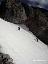
Head up the 2000’+/- snow couloir staying to the left to avoid sunrise rock fall and what was a huge dug out ice/rock trench in 2010. The climb allows for many safe break opportunities under the walls to the left. If not previously kicked out, it can be a calorie burner to be sure and we did not find any established kick steps in mid August, but it is my guess that at times you would. You have two options at about halfway up the couloir at a fork. We took the left option which ended on a bit of ice with an easy exit left on loose rock to the summit ridge of Diadem Peak. The right option would take you directly to the summit, but had a significant cornice over it in mid August, 2010. If you take the right option, exit up and right on steep terrain trying to avoid the cornice and you will find yourself just meters below the summit block. The left option lands you on the summit ridge where you will have to turn right and hike along the before mentioned cornice to the summit block.
While climbing the snow couloir, I advise either soloing the route as we did or switching leads placing snow protection. One climber will not be able to arrest another’s fall on such ground, although if you are well versed in proper self- arrest technique, you should be more than capable of arresting your own fall. Two people perishing because of one’s inability to arrest his/her own fall will serve as little comfort to those back home if such an accident were to occur. Descending this couloir in an uncontrolled fashion would more than likely be fatal, as it is steep with way too many rocks, trenches and crevasses below.
To reach the north ridge of Mount Woolley, descend the south ridge (500’+/-) of Diadem Peak. I removed my crampons for this rock ridge descent. At the col, put your crampons back on and head up the initially broad north ridge of Mount Woolley. Stay right to avoid a high bergschrund built into the corniced ridge that might or might not be showing itself depending on snow conditions. If in doubt, keep angling right as you ascend broad snow fields on the lower glaciated ridge. Eventually some rock will show itself at about the same time you can see Mount Alberta to the west. Join into the rock ridge and follow it to the summit avoiding the cornice that pretty much ran the length of the ridge in mid August, 2010. You will encounter one steep ice/snow step along the way. The summit proper is just right of the significant summit cornice. There was a summit register in 2010. A clear view of the east face of Mount Alberta is unimpeded from the small summit cairn. The North and South Twin as well as the Twin Tower are also in clear view.
Climbing Sequence
 |
 |
 |
 |
 |
 |
Climbing Sequence II
 |
 |
 |
 |
 |
Descent


Return back to the col. Rope up. As you descend the glacier, stay skiers left close to the scree field which, although it does not look it, actually rests on the glacier itself. I fell into a narrow, but deep crevasse only meters from the scree. Descend down to almost the icefall itself. There will be a large crevasse (that would swallow you whole if you slipped above it) that sits just to the right of where you need to hop onto the rocky shoulder that divides the previously mentioned left (climbers left) snow couloir from the icefall, both of which are impossible to descend all the way back to the glacier. Traverse the narrow shoulder at this point to skiers left and cross over the snow couloir by kicking steps diagonally down and right as you face the mountain. A non-arrested slip here would be fatal as this snow couloir turned into steep ice/rock towards the bottom in August, 2010. Once across the couloir and onto the rumble strewn broad rock ledges, take off your crampons and descend these rock ledges right to left. Watch for rock fall from above. We dodged several missiles on descent. You are looking for a cairned (2010) chimney descent onto the snow couloir that you ascended way down and left. Once back on the snow couloir, reapply crampons and descend back to the glacier, rope up and descend back to the tarn.
Either exit the glacier to the right of the gushing glacier melt streams below to avoid crossing them or cross them at the toe of the glacier. The closer you are to the tarn, the more difficult the crossings if it was a warm day. Return to the bivy and thus back to the Sunwapta River crossing. The before mentioned rapid crossing at the near end of the boulder field can be much more problematic to cross later in the day. We actually made a fairly bold jump from one boulder to the other sans packs (I threw my pack across).
Essential Gear
We used a 30m half rope for the glacier travel and soloed the southeast face of Diadem Peak and the north ridge of Mount Woolley and performed no raps. All glacier gear including your crevasse extraction kit. A selection of ice screws and/or pickets depending on when you are climbing the southeast face and your comfort level in soloing 40 degree snow/ice slopes. Once onto the summit ridges, the wind and temperatures can have an effect, so dress accordingly. Water is not that plentiful once you start the couloir ascent. I advise taking an adequate supply for the day. Crampons, helmet, harness, one alpine ax if you are quite experienced, an additional tool will be more comforting if less experienced on such slopes (40 degrees). Two hiking poles for the river and rapid crossings.External Links
100’s of Banff and Jasper National Park multi-pitch rock climbs, ice climbs, alpine climbs and scrambles, just scroll down to routesJasper National Park, Parks Canada
Best Eats in Canmore: Rocky Mountain Flatbread Company, all organic fare, not just a pizza place, but a true best of the best mountain local dining experience, great on site owner and customer service with a smile, not easily obtained in Canmore
Best Eats in Banff: The Bison, all organic/free range fare, with a detailed description of their suppliers. Recently expanded (2010), I recommend sticking with the downstairs. Better menu, prices and social ambience. Maybe retire to the bar upstairs for sunset or late night. Bison chili is amazing!
Best Coffee in Canmore: Beamers, the locals favorite, super wholesome lunch stuff, local guys, no attitude on service
Best Climbers Hangout: Summit Café, most likely place to find me or my brethren shooting the bull about beta. Best breakfast place in town, good coffee as well, serve Mennonite meats from Valbella, which is the best place to buy free range products anywhere in the world, right here in Canmore.
Climbing Gear: All way too expensive in the Bow Valley, but if you must, Mountain Magic in Banff is far superior to service and actual knowledge about climbing than the two in Canmore.