
-
 13937 Hits
-
 83.69% Score
-
 17 Votes
|
|
Mountain/Rock |
|---|---|
|
|
38.13970°N / 105.1564°W |
|
|
Custer |
|
|
Hiking |
|
|
Spring, Summer, Fall, Winter |
|
|
10334 ft / 3150 m |
|
|
Overview
 Outcrops along the Rudolph Mountain Trail
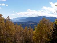
Rudolph Mountain rises to 10,334 feet in the rolling green Wet Mountains west of Pueblo, Colorado. The actual highpoint of Rudolph Mountain is wooded, but pleasant outlooks on the northwest side of the mountain grant the hiker wide-open views of the Sangre de Cristos, the Wet Mountain Valley, the northern Wet Mountains and, I’m told on a clear day, Pikes Peak.
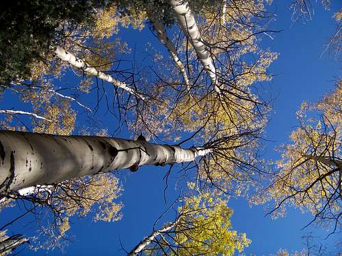
While Rudolph Mountain is a year-round peak, a visit in autumn is a special treat. In early fall, the summit area boasts large swarms of mating Ladybugs, while the flanks of Rudolph Mountain boast golden blazes of Aspen and warm orange groves of Gambel Oak.
Colorado Rank: 2,122nd highest peak in Colorado
Prominence: 994 feet
Mountain Range: Wet Mountains
USGS Quad: Hardscrabble Mountain
Maps: Trails Illustrated has yet to cover this lovely area. Useful maps include: The USGS Hardscrabble Mountain Quad (for detailed navigation) and the San Isabel National Forest area map.
Rank and Prominence Reference: Lists of John
Getting There
 Route Map
 Area Map
Rudolph Mountain sits about 34 miles as the crow flies to the west-southwest of Pueblo and 22 miles east-southeast of Cañon City. Rudolph Mountain is bordered to the north by CO Hwy 96, to the west by CO Hwy 165 and to the south by Custer CR 386.
Red Tape
 Autumn clouds and leaves
 Leaves blowing through the autumn sky
The summit of Rudolph Mountain lies right on the western boundary of this section of San Isabel National Forest. Please respect private land and do not wander west of the summit.
Camping & Lodging
 Golden Aspen reach for the sky
Trailhead Camping: There are a few rustic camp spots right at the trailhead and along Custer CR 386. However, there are no facilities (water or latrines) and the sites are right off of the road with very limited privacy.
National Forest Campgrounds
 Approaching Rudolph Mountain from the South
| Campground Name | Elevation | Sites | Nightly Rate | Season | Notes |
|---|---|---|---|---|---|
| St. Charles | 8,800 ft. | 15 | $15 | May through October | Near Lake Isabel Recreation Area |
| Ophir | 8,900 ft. | 30 | $15 | Late May to early September | Closest to Rudolph Mtn; Very close to Bishop's Castle |
| Davenport | 8,500 ft. | 12 | $13 | Late May to early September | Close to Ophir CG; next closest to Rudolph Mtn. |
| Oak Creek | 7,600 ft. | 16 | Free | Year-Round | Lowest elevation; Closest to Cañon City; No water |
| La Vista | 8,600 ft. | 27 | $15-$19 (RV) | Mid-April through Mid-October | Only CG in San Isabel NF with electric hookups |
 South from Rudolph Mountain
Cañon City
This community has a few limited lodging options, mostly on the simple end of the spectrum. Visit this page for more information about lodging in the Cañon City area.
Pueblo
This city of more than 100,000 residents has a reasonable selection of hotels and restaurants for visitors. Visit this page for more information about lodging in and around Pueblo.
Weather & Seasons
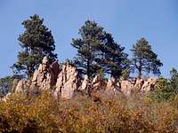 Outcrops and Ponderosa Pine
 Closeup of Gambel Oak leaves
The Wet Mountains generally tend to be warmer and drier than most mountain ranges in Colorado.
Summer: Expect summers to be relatively hot compared to other mountainous areas of Colorado.
Fall: The autumn leaf display in the Wet Mountains is simply spectacular. In addition the ubiquitous golden-hued Aspen, these mountains also boast thick stands of orange-to-crimson Gamble Oak.
Winter: Nowhere near as high or steep as the Sangre de Cristo Mountains to their west, many of the Wet Mountain summits sit below timberline. Combined with a generally smaller snow-pack, much (though not all!) of the Wet Mountains can be enjoyed in snow season without that tingling fear of avalanche experienced in much of the Colorado high country.
Spring: The snows will typically melt earlier in the Spring in the Wet Mountains than in other, higher ranges and mountains to the north.