
-
 52736 Hits
-
 87.25% Score
-
 27 Votes
|
|
Custom Object |
|---|---|
|
|
60.29362°N / 140.93056°W |
|
|
Area/Range |
Overview
This page will always be a work in progress. However, I am taking the initiative to make an informative and quality page on one of the most rugged and challenging mountain ranges in the world.Most places throughout the Saint Elias Mountains can only be accessed via a bush plane and they can usually take you up high on a glacier near your mountain of choice. There are however places where one can walk for tens of miles to approach climbs with air drops for food and gear.
The vast majority of people even in Canada and the United States will never even set eyes on these mountains. Your best chance to see them is by finding yourself on a boat in the fjords north of Juneau. Even then, you are one very lucky duck if you can actually see any mountains at all as they are nearly always plagued by some of the world's worst weather.
Large pacific storms routinely hit these mountains with very little warning as very strong low pressure systems come off the Gulf of Alaska at striking speeds. Within minutes, crystal clear views of these mountains will turn into sub-zero temperatures, hurricane force winds and complete whiteout conditions. It is imperative you are prepared for such weather when travelling in these mountains.
Many of the highest peaks in the Saint Elias Mountains are located along the Alaska/Yukon Territory border including Saint Elias, the second highest in the range. Further south, ironically named Mount Fairweather sits along the border of Alaska and British Columbia.
Mount Saint Elias is highly noted as it's the highest mountain so close to the ocean. Only 12 horizontal miles lead from the head of Taan fjord to the summit giving it an incredible amount of overall vertical relief. Denali and other Himalaya peaks don't quite have as much vertical relief despite being higher in elevation. If you choose to climb Saint Elias from tidewater, you have over 18,000 feet of ascending to do!
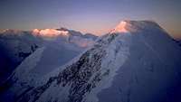
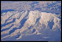
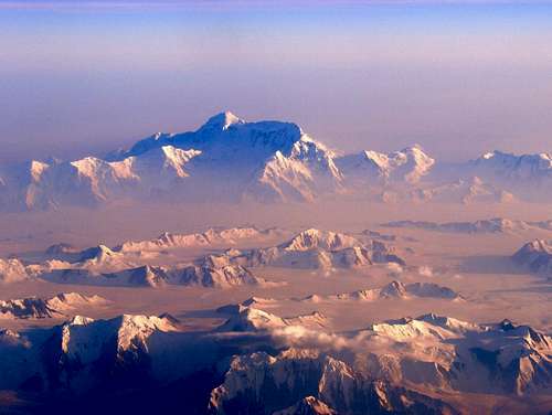 Mount Saint Elias seen above the nearly constant low cloud deck from an airplane
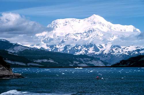 Mount Saint Elias seen from a boat in Icy Bay
The Saint Elias Mountains
The MountainsThe Saint Elias Mountains are one of the most rugged and harsh mountain ranges in the world. They are part of the North American Pacific Coast ranges and are within the Wrnagell Saint Elias and Glacier Bay National Parks in Alaska, as well as the Kluane National Park in Canada's Yukon Territory. The highest peaks in the range are as follows following the 1500 foot prominence rule:
| Mountain | Height | Location | Easiest Route | First Ascent | Notes | |
|---|---|---|---|---|---|---|
| m | ft | |||||
| Mount Logan | 5,959 | 19,551 | Yukon | The King Trench | June 23, 1925 under leadership of Albert McCarthy One of the greatest mountaineering achievements | Highest mountain in Canada |
| Mount Saint Elias | 5,489 | 18,008 | Alaska-Yukon | Southwest Ridge (Harvard Route) | July 31, 1897 under leadership of the Duke of Abruzzi | Second highest in both Canada and the United States |
| Mount Lucania | 5,226 | 17,147 | Yukon | 1937 by Washburn and Bates | #3 in Canada | |
| King Peak | 5,173 | 16,971 | Yukon | King Trench/North Face traverse/West Ridge | June 6, 1952 by Hart and Thayer | #4 in Canada |
| Mount Steele | 5,073 | 16,644 | Yukon | Southwest Ridge | 1935 led by Walter Wood | #5 in Canada |
| Mount Bona | 5,005 | 16,421 | Alaska | East Ridge | July 2, 1930 by Allen Carpé, Terris Moore, and Andrew Taylor | #5 in the US; Highest volcano in the US |
| Mount Wood | 4,842 | 15,885 | Yukon | East Face | 1941 by Walter Wood, Anderson Blakewell, and Albert Jackman | |
| Mount Vancouver | 4,812 | 15,787 | Yukon | Northwest Ridge | 1949 led by William Hainsworth | |
| Mount Churchill | 4,766 | 15,638 | Alaska | South Ridge | August 20, 1951 by Gates and Lindberg | 4th highest volcano in US |
| Mount Slaggard | 4,742 | 15,557 | Yukon | East Ridge | 1959 | |
| Mount Macaulay | 4,690 | 15,387 | Yukon | |||
| Mount Fairweather | 4,671 | 15,325 | BC-Alaska | Southeast Ridge | June 8, 1931 by Allen Carpe and Terris Moore | #1 in BC |
| Mount Hubbard | 4,577 | 15,015 | Yukon | Cathedral Glacier | Summer 1951 led by Walter Wood | |
| Mount Bear | 4,520 | 14,831 | Alaska | 1951 by Alfred Baxter Jr, Rupert Gates, and Jon Lindbergh | ||
| Mount Walsh | 4,507 | 14,787 | Yukon | North Ridge | Bob Bates | |
| Mount Alverstone | 4,439 | 14,565 | Alaska-Yukon | Cathedral Glacier | Summer 1951 led by Walter Wood | |
| University Peak | 4,410 | 14,470 | Alaska | North Ridge | June 19, 1955 led by Kieth Hart | Named after the University of Alaska |
| McArthur Peak | 4,389 | 14,400 | Yukon | West Ridge | 1961 | |
| Mount Augusta | 4,289 | 14,070 | Alaska-Yukon | West Ridge | 1952 led by Peter Schoening | |
| Mount Kennedy | 4,238 | 13,905 | Yukon | Cathedral Glacier/West Ridge | Spring 1965 by a team led by led by Jim Whittaker that included senator Robert Kennedy | Peak named after president John F Kennedy |
| Mount Strickland | 4,260 | 13,976 | Yukon | 1959 | ||
| Avalanche Peak | 4,228 | 13,871 | Yukon | 1969 | ||
| Mount Cook | 4,196 | 13,766 | Alaska-Yukon | 1953 by Kelley, McGowan, Miller and Mohling | ||
Many of these peaks have a considerable amount of satellite peaks however due to the massive nature of this mountain range, these are often disregarded as singular mountains. Often enough, prominence rules in these mountains are much higher than in places like Colorado, where 300 feet is often the prominence rule. Much of northern Canada follows a 500 meter prominence cutoff.
Climbing just one of these peaks will provide you with an experience that will travel with you throughout your entire life. It is clear to see the forefront runners in first ascents in this area. Some of the original Harvard Mountaineers club members including Henry Bradford Washburn and Bob Bates put of numerous of ascents in these mountains. Perhapd the most accomplished mountaineer in the Saint Elias Mountains is Walter Wood. Not only known for his series of Saint Elias first ascents but also for his glaciology research and work with the US military during World War Two. Wood carried colonel status in the US military. Keith Hart was also successful in garnering first ascents.
In more recent times, accomplished mountaineer and Colorado native Gerry Roach has led very successful expeditions into the Saint Elias Mountains.
Geology
Most of these mountains are non volcanic however, on the western margin parts of the range are, and two of the highest peaks are in fact stratovolcanoes. Mount Churchill and Mount Bona are volcanoes similar to Mount Rainier. Mount Bona is known as the highest volcano in the United States.
The Saint Elias Mountains are a result of large scale uplift caused by the North American plate riding over the subducting Pacific plate. The still active Fairweather fault to the west of the Saint Elias Mountains has been the plane up uplift for the last ten million years. Due to the cold and wet climate in the area, glaciers are fast to form and have done well to carve down and reverse vertical uplift, ever slowly eroding the mountains and carving out large valleys and ridges. Today, some of the largest glaciers in the world, particularly the Hubbard and Seward Glaciers. The Hubbard is the longest and largest alpine glacier (excluding Antarctica and Greenland) in the world at nearly 75 miles in length.
These mountains, together with the Wrangell Mountains form the Wrangell/Saint Elias National Park and Preserve in Alaska. This is the largest nationally set aside piece of land in the world. The eastern portion of the Saint Elias Mountains lie in the Yukon's Kluane National Park and Reserve.
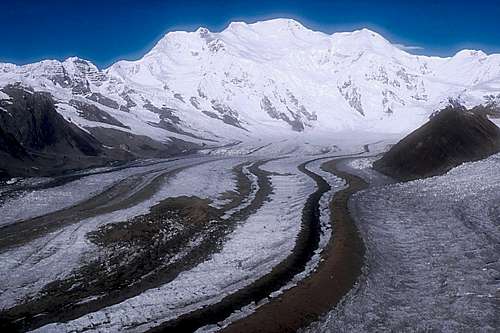 Kennecott glacier from near McCarthy in the Wrangell Mountains
Photo Album
Below is likely one of the best photo collections of the Saint Elias Mountains. Not many people ever come here and the ones that do will find it very difficult to get high quality photos as camera equipment is heavy and doesn't usually bode well when it's very cold and windy. Despite this, great photos do exist and Summitpost has a great collection. Some of this collection can be seen below. Mount Saint Elias in stunning fashion Mount Saint Elias in stunning fashion | 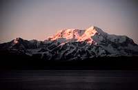 Sunset over Saint Elias Sunset over Saint Elias | 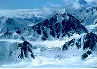 Mt. Lucania Mt. Lucania | 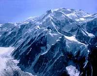 Mt. Lucania Mt. Lucania | 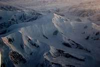 Sunrise on Mt. Steele Sunrise on Mt. Steele |
 Sunrise alpenglow on Mt. Slaggard Sunrise alpenglow on Mt. Slaggard | 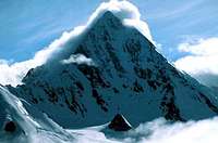 Mt. Pinnacle Mt. Pinnacle | 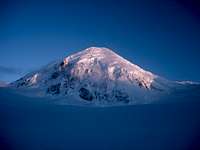 Sunset on Mt. Fairweather Sunset on Mt. Fairweather | 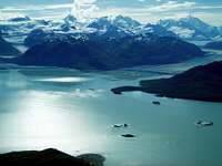 Mt. Fairweather above Glacier Bay Mt. Fairweather above Glacier Bay | 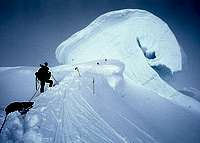 Huge cornice on Mt. Logan Huge cornice on Mt. Logan |
 Aerial view of Mt. Logan Aerial view of Mt. Logan | 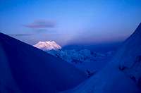 Sunset over Mt. Vancouver Sunset over Mt. Vancouver | 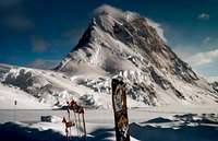 King Peak King Peak | 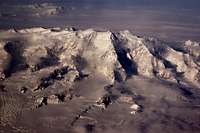 Logan Massif Logan Massif |
Some Climbing History
The first ascent of Saint Elias was made on July 31st 1897 led by the world renown Prince Luigi Amadeo di Savoia who was also the founder of today's standard route on K2. His party ascended the Abruzzi Ridge, a ridge dropping north off from the summit into the Yukon. This route is typically no longer used due to the large ice fall dangers.The second successful summit attempt wasn't until 1946 when a team from the Harvard Mountaineering Club climbed the southwest ridge. They started from sea level at Icy Bay and it took them eight days to approach on the glacier that ends at Taan fjord. Three days afterwards they made the summit. This route is often considered the Harvard Route in their honor. Some of the members of this team went on to climb many more mountains in the area, including other first ascents.
The first ascent of Mt. Logan was a 65 day trek that involved walking cross country 120 miles from the town of McCarthy, where the train lines ended. On June 23, 1925, leader Albert H. MacCarthy, H.F. Lambart, Allen Carpé, W.W. Foster, N. Read and Andy Taylor summitted. The second ascent wasn't until 1957.
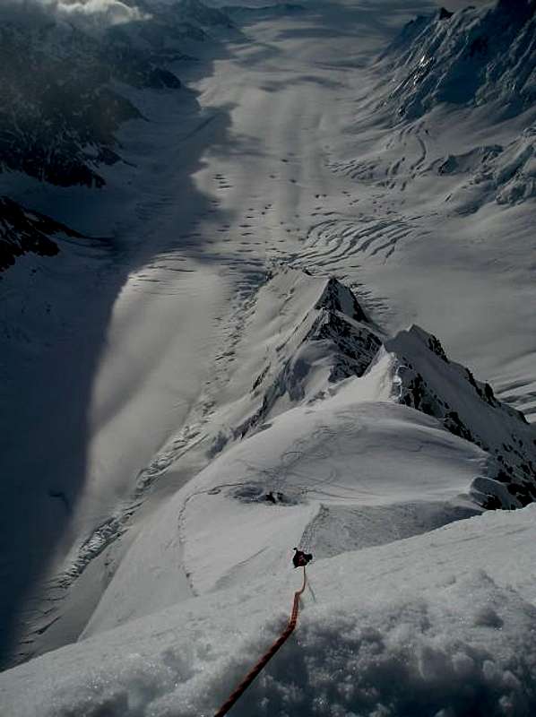 Looking down the lower east ridge on the Logan Massif
Colorado's own Gerry Roach made the summit of Saint Elias in May of 2000 to finish his North America highest 10 peak list. He ascended the south ridge.
Camping and Required Gear
The Wrangell Saint Elias National Park does not have any formal campgrounds or lodges within the park. Camping is usually all done in the back-country or along public lands along roads. There are however 13 restored mining/hunting cabins located within the park that can be used on a first come-first serve basis. The four villages near the park do offer bed and breakfast type lodging.You will need to bring everything you need to survive in some of the world's harshest conditions if you decide to climb any of these mountains. If flying in to the heart of the mountains for a glacier drop-off, your guide may provide some of your gear and provide your food but you will absolutely need these things:
1. Sleeping bag rated at some very large number below zero...aka an expedition bag
2. Sleeping pad that will provide insulation from that ice and snow you will be sleeping on
3. Mountaineering boots that will keep your feet warm. Plastics will likely be required and MUST be crampon compatible
4. Expedition jacket with lots of Gore-Tex rain gear including heavy gloves, glacier glasses, wool socks (many pairs), and face protection.
5. Lots of mountaineering skill including ice climbing, glacier travelling, crevasse rescue, route-finding and ability to tolerate mother natures' worst crap!
If you are climbing without a guide, every person in your team will need access to this additional individual and team gear:
1. A very high quality 4 season tent
2. Cooking equipment with fuel that will work at high altitudes and cold temperatures
3. Ropes and harnesses
4. Good crampons designed for the hardest part of the route you choose
5. Climbing helmet
6. At least enough food to last you fifty percent longer than you expect to be on the mountain; ideally twice the food. You may be sitting in your tent for days during storms and simply keeping warm can take loads of energy.
7. Any climbing protection you may need including ice screws, pickets, or rock cams.
8. Knowledge on how to use all the above mentioned gear
When to climb
The Wrangell Saint Elias National Park is best visited from May through August. Not surprisingly, this is also the "least terrible" time to climb these mountains. As early as mid-September huge storms can dump feet of snow on the mountains and snow can and will fall any time of year.Saint Elias sees over 100 feet of snow each year and during the summer months it is imperative that your team keeps an eye out for potential avalanche dangers. All this snow gets slightly softer during the summer and massive slides do occur. Other dangers include cornice failures and icefalls, which can prove disaster if your team is in the wrong place at the wrong time.
Red Tape
The Wrangell Saint Elias National Park has no entrance fee or gates and is open all year. This doesn't mean you can get to the park all year though. Winter usually renders all roads impassible and most air services shut down for the winter. It's always dark anyway.That being said, despite the National Park status, there is no permit or official registration required however it is requested you check in with park rangers before and after your climb. Keep in mind this park has no search and rescue service. If you don't return, no one will come looking for you. You are truly on your own and will be relying on your team, your gear, and your own judgement.
Now if you plan on crossing over into Canada other rules do apply.
See the Kluane National Park site for details.
As always, LEAVE NO TRACE
Guides/Air service
There are a number of guide and air services available. A few of the more noteworthy ones follow.Saint Elias Alpine Guides
Kennicott Wilderness Guides
Big list of other guides
Wrangell Mountain Air
Copper Valley Air
Other air services
External Links
For more information about climbing in the Saint Elias Mountains, see these links.National Park Service
National Geographic
Trek Alaska
Detailed weather forecast
South Ridge Trip Report
Saint Elias skiing