
|
|
Mountain/Rock |
|---|---|
|
|
45.61690°N / 114.8368°W |
|
|
Idaho |
|
|
Hiking, Mixed, Scrambling |
|
|
Summer, Fall |
|
|
8943 ft / 2726 m |
|
|
Overview
 North face of Salmon Mountain
 The Lookout
 The summit
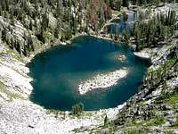 Unnamed north lake
 Unnamed south lake
 Summit vegetation
 East side rocks
 North bowl
 Towards the summit
 East side pond
 July spring
Salmon Mountain is one of the highest summits on the divide between the Clearwater (Selway) basin and the Salmon basin. Except for a very few points in the main Bitterroots on the Idaho/Montana border there is no higher Idaho point between it and the Canadian border; a distance of 250 miles. The mountain is formed by a large ridge running southwest to northeast. The west side is of a fairly gentle terrain, while the east side is formed by a series of six glacially carved basins stretched out over approximately three miles. The high point is located between the second and third basins from the south end. All of these basins, except the southernmost one support a subalpine lake. Only the two northernmost ones, Elk Track and Gold Pan have names and only the latter supports a fish population. There are approximately ten smaller ponds on the mountain as well. The highpoint rises 600 feet above the lake in the cirque to its south and 1,000 feet above the lake to the northeast. The mountain rises nearly 5,000 feet above Sabe Creek to the southwest, over 4,000 feet above the Little Clearwater River to the north and the upper Selway River to the east. Salmon Mountain has 1,383 feet of prominence.
The summit is at the treeline for the area and supports a mosaic of open subalpine fir, whitebark pine and subalpine larch forests as well as subalpine grasslands and talus slopes. Subalpine larch is found in the U.S. in the main Rockies, Cascades, Selkirks and the Bitterroots. The occurrence on Salmon Mountain is one of the southernmost for the species and is well established with acres of trees, some being uncharacteristically large. The rock type is a coarse hornbendebiotite granodiorite, part of the Idaho Batholith.
The current summit lookout, one of the very few still manned, was built in 1949. The first lookout was operated out of a tent in 1920. In 1928 a permanent cabin was built before being replaced by the current structure. At one time a crude road reached to the slopes just below the lookout, but this has since served as part of the trail.
Salmon Mountain Rearch Natural Area
The Salmon Mountain RNA was established in 1998 and covers 1,923 acres on the divide between the Selway and Salmon basins, within the Frank Church – River of No Return Wilderness, which with the adjacent Selway Bitterroot Wilderness to the north forms the largest wilderness block designated in the lower 48 states. Elevations in the RNA range from 6360 feet along Three Lakes Creek to 8800 feet on the RNA boundary just below Salmon Mountain lookout. The forests occur as "ribbon forests", which are elongated, narrow strips of timber perpendicular to the prevailing wind. Interspersed within the timbered areas are narrow bands of mesic subalpine meadows called "snow glades". The meadows are dominated by green fescue and a variety of sedges and rushes. Forbs such as phlox, coiled-beak lousewort, and pussytoes present seasonal wildflower displays. The RNA also contains intermittent and permanent streams, cold springs, low production lakes, and lakes without fish. Dendrochronology and fire history studies have taken place within the RNA.
Getting There
 Looking down the north ridge
 Lower trail
 Summit from trail
 Easy trail
From Highway 95, turn east into Grangeville and continue on main street (Highway 13) for a long mile to the east edge of town. Town ends abruptly at the intersection of Highway 13 and the Mt. Idaho Grade road. From this intersection go south (right) on the Mt. Idaho Grade road. After driving approximately 0.7 miles take the curve to the left at the drive-in theater (the curve is the main road). Continue on through the cluster of houses known as Mt. Idaho and soon the road will descend into the deep canyon of the South Fork of the Clearwater River. The road hits the canyon bottom and Highway 14 joins from the left, 9 miles after the theater curve.
At the bottom of the grade continue straight for 38 miles to the Red River Road. Turn right and continue up Red River for about 14 more miles to Red River Ranger Station. Turn right (keeping on the pavement) and go through the Ranger Station for 0.4 mile to the Montana Road (Road 468). Turn off the pavement on this road and continue for 45.5 miles to the trailhead to the Salmon Mountain Lookout. The summit is less than two miles of hiking up a steady, but gentle grade. From Grangeville, the drive will take between three and four hours depending upon traffic and driving conditions.
Caution should be taken on much of this route. For several miles on Highway 14 just east of the base of Mount Idaho Grade, the road is very narrow and twisted. Watch the speed and stay on the right side of the road and hope the oncoming traffic (largely composed of RVs and logging trucks) does as well. The shoulder is falling into the river on this already narrow road and in some places even the white strip is going, leaving absolutely no space between you and the river. On the mountainous portion, the road is very narrow and steep from a little beyond the junction with Road 285, which is about 19 miles in from the pavement, to Poet Creek. Another particularly bad stretch is the few miles between Dry Saddle (about 31 miles from the pavement) to the head of Sabe Creek. If you meet another vehicle on some of these road segments, one of you could be backing up a long way.
Part of the adventure of going into this part of Idaho is driving along the South Fork Clearwater River. This small, but beautiful river has a steep grade over endless boulders of class III, IV, and V whitewater in the spring. About 10-15 miles upstream the canyon tightens into a spectacular gorge with miles of technical climbing that is not climbed. Low elevation mountain goats are not an uncommon site here. All is especially beautiful in the fall when the larch and broadleaf trees lining the rocky stream turn gold. The river also supports good runs of steelhead and Chinook salmon, which can be seen jumping some of the small waterfalls during the appropriate season.
Red Tape
None, other than standard wilderness regulations.Camping
 Big subalpine larch
At-large camping can be done nearly anywhere on the mountain or adjacent any of the lakes. Keep in mind that the descent down to any of the lakes can be steep and dangerous with no trails. Also camping in the RNA is discouraged. There are crude designated campgrounds about a mile to the east and west of the trailhead on the main Magruder Road. These campgrounds offer only some road pull-outs and lack water or any other amenity. There are similar campgrounds along the road further to the west or east. The close campground about a mile west of the trailhead has springs and small streams adjacent the road that provides close access to water. Most of these campgrounds also serve as trailheads so be sure not to block livestock ramps with your camp or vehicle.
The Magruder Ranger House on the Selway River can be rented for those traveling through the area; however, this is not real close to Salmon Mountain. This rustic cabin is part of an old ranger station from a time when there were far more Forest Service stations and cabins in the backwoods. It is about 22 miles east of Salmon Mountain on the Magruder Road and 70 miles east of Hamilton, Montana.
 Unnamed north basin lake
When To Climb
Obviously the summer is the best time to reach this summit. The Magruder Road is not cleared in the winter so it is impossible to get anywhere near the mountain during that season. At this high elevation come prepared for any kind of weather regardless of the time of year, even on days that seem warm in the morning. Storms can and often do blow up out of nowhere and can drop temperatures dramatically and bring rain or snow. It is possible to snowmobile along the Magruder Road, but it’s a long way to Salmon Mountain from the accessible ends of the road to anywhere. Generally it’s a good rule to only snowmobile as far as you are willing to walk out. If this rule is followed, it is not possible to get close to Salmon Mountain in the winter. The south basin
More Information and Current Conditions
Go to the mountain prepared for variable conditions. Salmon Mountain rises nearly a mile above the Clearwater and Salmon River basins in some of the most remote country in the lower 48 states. Weather and temperatures can vary dramatically between the canyon and the mountain. While it’s a relatively safe mountain given the closeness of the Magruder Road, any trip in this area that strays from this road should involve caution and good planning.Before traveling the Magruder Road or for more information and current conditions in the Salmon Mountain vicinity, contact the Nez Perce National Forest or the Red River (Elk City) Ranger Station if coming from the west. If coming from Montana in the east, contact the West Fork Ranger District of the Bitterroot National Forest:
Nez Perce National Forest
104 Airport Road
Grangeville, ID 83530
208-983-1950
Red River Ranger Station
Elk City Ranger Station
300 American River Road
Elk City, ID 83525
208-842-2245
Bitterroot National Forest
1801 North First Street
Hamilton, MT 59840
Front Desk: (406) 363-7100
West Fork Ranger District
6735 West Fork Road
Darby, MT 59829
(406) 821-3269
NOAA Forecast
 Headwaters of the Selway River