
-
 35468 Hits
-
 81.84% Score
-
 14 Votes
|
|
Area/Range |
|---|---|
|
|
34.47950°N / 119.4317°W |
|
|
Hiking |
|
|
Overview

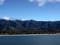
The Santa Ynez Mountains reside in Santa Barbara County running parallel with the coastline. The range forms a long mountainous wall seperating the coast from the Santa Ynez Valley. The city of Santa Barbara is overlooked by the famous Mission Crags or known to hikers as Cathedral Peak. The range can be broken down into three parts. The eastern third is where the unnamed range highpoint Point 4864 resides. Other notable peaks in this section include the rugged White Ledge Peak 4,640ft., Noon Peak 4,084ft., Divide Peak 4,707ft., Montecito Peak 3,214ft. and the Santa Barbara City highpoint La Cumbre Peak 3,985ft. The middle section is dominated with Santa Ynez Peak 4,298ft., which is the most prominent peak in the range but not the highest. This section ends in the west with Gaviota Peak 2,458ft., in my opinion the best views of the coast in the entire range are to be found at this little peak. Also the peaks in this section provide great places to witness rocket launches from Vandenberg Air Forse Base. The western third of the range is dominated with private property and Vandenberg Air Force Base thus preventing access to any of the peaks in this section. The most important peak in this section is Tranquillon Peak 2,159ft. There are three listed Lower Peaks in the range, Gaviota Peak, Cathedral Peak, and Montecito Peak. The only P2000 peak is Santa Ynez Peak.
Getting There

The 101 Highway runs parallel, south slope, with the Santa Ynez Mountains so this can be used for most approaches. Also on the north slope of the range Highway 154 provides access. Also along the backbone of the range runs the rough asphalt sometimes dirt road Camino Cielo. Main access points to Camino Cielo, from the westside El Refugio Road, on the eastside Gibralter Road, and in the center Highway 154 at the San Marcos Pass.
Red Tape
The Santa Ynez Mountains are within Los Padres National Forest so a Adventure Pass would be required for parking. A Adventure Pass can usually be bought at most gas stations near forest roads. The remote nature of this part of the National Forest makes it pretty doubtful that rangers will be checking for permits, but it could happen. Also Gaviota Peak is within Gaviota State Beach. The trailhead for this peak has a parking self issue stand. Bring one dollar bills for it though.
External Links

For current conditions in Los Padres National Forest.
For a current launch schedule go to Vanderberg Air Force Base.
For more information on the listed peaks go to Lower Peaks Committee.
For current weather go to Weather Underground.
For a interesting native american site go to Painted Cave that was created by the local Chumash.
Camping
For camping in Los Padres National Forest Campgrounds.For camping at any of the local State Beaches.
1. Gaviota State Beach
2. El Capitan State Beach
3. El Refugio State Beach
My personal favorite place to camp is El Capitan State Beach.
Other Summitpost peak pages in Santa Barbara County
1. El Montanon, highpoint of Channel Islands National Park, Santa Cruz Island2. Cachuma Mountain, San Rafael Mountains
Peaks over three thousand feet
Santa Ynez peaks over three thousand feet of elevation1. Point 4864ft.
2. BM 4819ft.
3. Divide Peak 4707ft.
4. White Ledge Peak 4640ft.
5. Santa Ynez Peak 4298ft.
6. Noon Peak 4084ft.
7. Broadcast Peak 4028ft.
8. La Cumbre Peak 3985ft.
9. BM 3662ft.
10. Cathedral Peak 3333ft.
11. Arlington Peak 3250ft.
12. Montecito 3214ft.
13. Brush Peak 3069ft.
14. Condor Point 3001ft.