
-
 2708 Hits
-
 86.37% Score
-
 22 Votes
|
|
Route |
|---|---|
|
|
46.61465°N / 11.95094°E |
|
|
Download GPX » View Route on Map |
|
|
Hiking |
|
|
Summer, Fall |
|
|
Half a day |
|
|
Medium hard hike up (T3) |
|
|
Introduction
This is the only "normal" ascent route on Sass dla Crusc from the west, even more frequented than the much easier eastern ascent. It's a fantastic, very scenic hike up with some ferrata sections. From the beautiful Santa Croce sanctuary the route leads you up just below the high, vertical walls, detours them in a long crossing, exits on the high saddle and finally climbs on top by an easy ridge.General Information
Exposition: On many places the route is exposed, even if the slopes below our feet are nowhere really vertical.
Orientation: It's really easy to orient, the route is well marked (No. 7 till the notch). See the GPX track in the header!
Slope orientation: Till Ju dla Crusc (Passo di S. Croce, Kreuzkofelscharte) we cross the W oriented slopes. The summit ridge is S and E oriented.
Objective dangers: Usually the route is objectively quite safe. On our ascent (mid August) it was however just a day after some snow fell on altitudes above 2700 m. In the final crossing below the vertical walls rocks were constantly falling down and looking towards the sky you could see ice crystals falling through the air. So, we were running over that part as fast as we could.
Best season: Summer months, normally from July till October.
Gear: Good shoes and poles are sufficient. If you'd be able to anticipate rock falls (see above), a helmet is also a good idea. Otherwise the climbers preceding you are nowhere really above you. Less experienced can benefit from a ferrata set.
Tour start: Santa Croce sanctuary, 2045 m, which can be reached from Pedratsches (Badia) by a chair lift (or on foot in 2 h).
Highest point: 2907 m.
Altitude to overcome: cca 900 m.
Time for ascent: 3 h (2 h to the notch, 1 h on the summit).
Map: Tabacco. Cortina d'Ampezzo e Dolomiti Ampezzane. 1:25000.
Getting There

Santa Croce / Heiligkreuz
Route Description
From the sanctuary you start ascending by the path No. 7 towards the walls. Soon it starts crossing the screes, then it crosses a ravine and when the terrain gets rocky we get already some help from the first cables. The route climbs up on a narrow ledge. Towards the walls |  View back on the church |  Below the walls |
Then the crossing continues, but on some places we are also climbing more direcly up by rocky ribs. All more exposed places are secured, but on some less steep places we also need to scramble up without security devices. After another crossing the last climb brings us up till just below the completely vertical summit walls. There we continue by a quite comfortable band, around another edge we reach the last band which brings us soon out of walls, into the broad ravine below Ju dla Crusc (Santa Croce Pass, 2612 m).
 Gaining altitude |  Crossing below the walls |  Towards the exit ravine |
If you expect to only walk up the last 150 meters, you're mistaken. The terrain is still very steep and the route prefers to keep left - just to the rocky walls, where the protection cable is installed.

On Ju dla Crusc

The south ridge
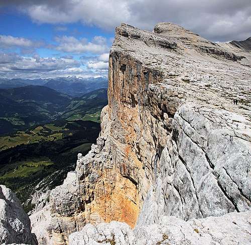 The completely vertical western walls | 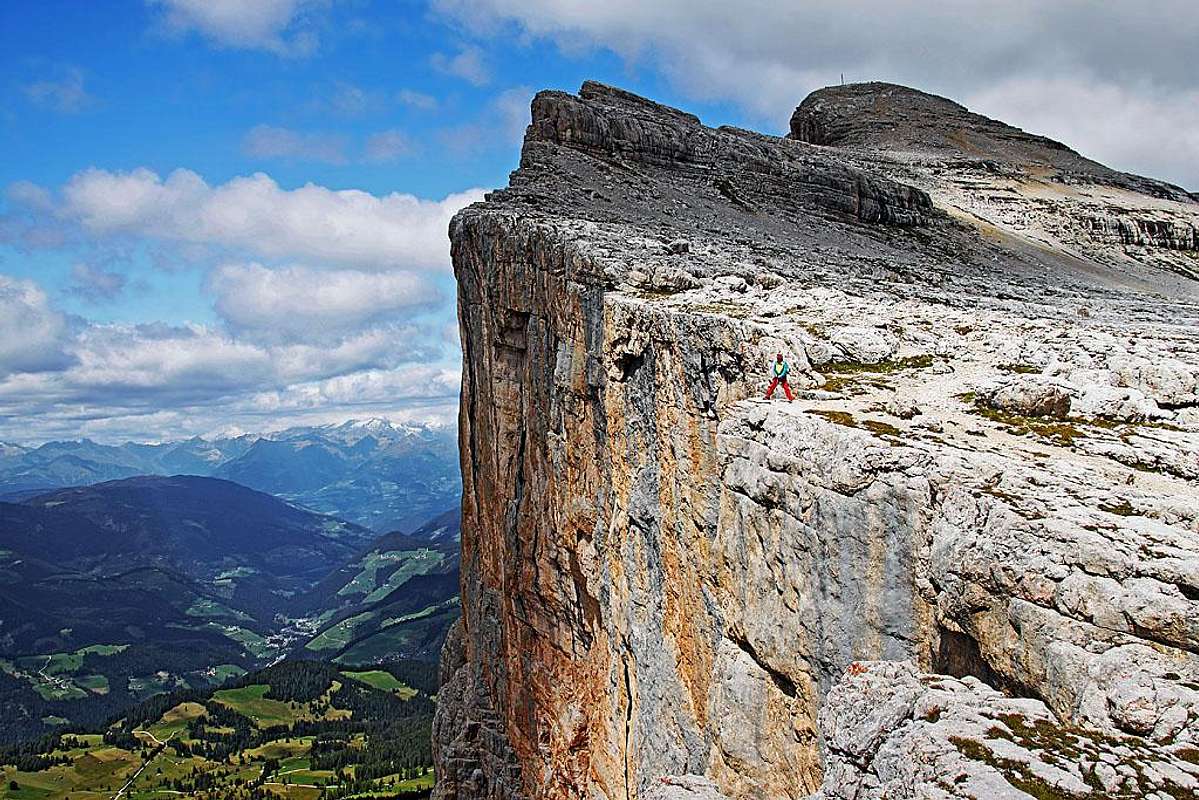 Along the main (south) ridge |
Descents
The fastest option to get down to the sanctuary is still the ascent route. But many visitors decide for the longer option - via Forcella Medesc, 2533 m. This one is situated in the main ridge more towards the SE, so closer to the nearby 3000-er of Lavarella. Even on the Tabacco map (but we have an old one) the direct connection between Passo di Santa Croce (where we likely have left our backpacks) and Forcella Medesc is not drawn. But there is a new connecting marked path (12B). We descend from Passo di Santa Croce just a few minutes and there we notice marks deterring right from the well beaten path No. 7. So we can cross the NE slopes of the main ridge quite high, with only small altitude losses. From Forcella Medesc we descend by a good path (No. 12) towards the SW and later W (we haven't done that part yet). On the altitude of some 2020 m we deter right and a nice, panoramic path No. 12A brings us with only little losses of altitude to the sanctuary. A bit longer, but nice and much easier return variant.Note
I was hesitating if to create a separate page of this route. Then I remembered a small event which proves that accurate and detailed information can be important. With Jasmina we were slowly climbing up by the ferrata section, each of us carrying a very heavy backpack (with everything in for a 4-day trek). So, a guy caught us and we let him pass by. But then he stopped and said he will wait his friends. A few minutes later we saw him returning. His friends obviously decided not to continue. Even if the route is only medium hard hike up, its difficulties obviously exceeded their expectations.
On the summit