
|
|
Mountain/Rock |
|---|---|
|
|
47.61944°N / 120.58865°W |
|
|
Hiking |
|
|
Spring, Summer, Fall |
|
|
3172 ft / 967 m |
|
|
Disclaimer
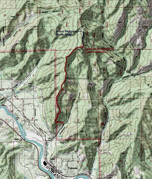 Map of the Route
On Peakbagger.com and other sites, Sauer Mountain and Peak 3172 are listed as two separate summits. The reason why I combined them together on this page is the fact that they are on the same trail and on the same ridge. Sauer Mountain only has 76 feet of prominence and is smaller than Peak 3172 and barely any distance (0.3 miles) from the Peak 3172. In addition 3172 is the highest point on the ridge and has well over 400 feet of prominence. Personally this really feels like one mountain so because of the fact this mountain ridge is oddly named I combined the two for this one page.
In addition most people refer to this peak as Sauer Mountain despite the fact that there are a number of signs on the trail referring it to Sauer's Mountain. All should be noted when going up this particular mountain.
Overview
 Leavenworth from Sauer's Mountain
Sauer Mountain located just east of Levenworth is a famous springtime hike in the area. The trail which is located and maintained by the Sauer's family was actually built by the family decades ago. At the time of them building this beauiful trail the Sauer's family received complaint from the national forest for them building this trail. Though this trail has become popular with hikers in the region you will not see this trail listed in any guidebook. This does not mean that this mountain is not pretty or worthwhile to go to.
 Flowers on the trail
At 5.6 miles roundtrip to the true summit or 5 miles and to subpeak advertised as Sauer Mountain with 2000 feet of elevation gain this peak is easy enough that even moderate hikers will not find the way up not being much of an issue. Among the only "issues" some might find is that at one point early in the hike the trail skirts close to the edge of cliff but even here is not really a catwalk. After that little section roughly 0.6 mile from the beginning the rest of trail is pretty tame and often climbs at a moderate pitch with some gentler and steeper grades.
 The trail for flowers!!
There are many charms to this trail. First the trail in spring is covered by arguably some of the prettiest flowers you can see in May. More than a number of time excellent views of Leavonworth and the higher peaks behind Leavonworth show in view from this mountain. Along with that on a clear day you can see Glacier Peak from this mountain. It also is in a rainshadow in the Cascades meaning that rainy weather is much less an issue on this trail than on other mountains in the region. With great views, pretty flowers and a nicely laid out everyone should really thank the Sauer's family for creating this wonderful gem.
 Flowers on edges!!
The summit that is listed on many websites as Sauer's Mountain has the best views of downtown Leavonworth. It is cairned with the viewpoint even labeled with the view. From this summit there is a easy to follow bootpath-trail to Point 3172 which is uncairned but also contains decents views to the north and northeast. North of there is another subpeak listed by some as Point 3160 which is clearly shorter and also has views mostly north. Personally I believe all three should be visited because each has their own charm.
As fort the time to go up it is clearly May. The weather in the summer can get well over 100 here. And the trail tends to be more dusty. Also many of the flowers come out in spring. Many of the mountains west of Leavonworth are still snowcapped in May making for a beautiful backdrop. Finally with the summer season after that many of the higher mountains are probably better, cooler and prettier choices once the snow has melted.
 View from the highest point
This mountain is closed usually from mid October to late April due to snowcover. It is on private property so do not attempt to go to this trailhead at that time.
Getting There
VIA THE SAUER MOUNTAIN TRAILHEAD: Take Highway three miles east from Leavenworth. Make a left at light leading to Peshastin. Cross a concrete bridge over the Wenatchee River and continue through the town until it goes under the railroad tracks. Take the left turn which will become become North Road. One mile up the road before the cemetery, make a right onto Anderson Canyon Road. Stay on the road 0.6 miles to the trailhead which will be at the very end on your left hand side.Red Tape
Though parking is complimentary, donations are accepted in the donation bin by the trailhead registration stand. The trailhead is also CLOSED from mid-October to late April due to snow. Parking there during this time is considered tresspassing on private property. Out of respect of the Sauer's family due not go there during these times!!!!Camping
NO OVERNIGHT PARKING PERMITTED!!!! PRIVATE PROPERTY!!!!External Links
Great link to information on the Sauer Mountain TrailLots of pictures from the trail on this site
Redwic - May 7, 2012 11:26 pm - Hasn't voted
CorrectionsCorrection #1: There is no apostrophe. It should be "Sauer Mountain". I am actually going to notify the PB website about that, as well. If you read the page closely, it was a member-submitted "peak" (much like SP is), not originated by the PB administrators. Sometimes errors like this happen, even on SP. Correction #2: Point 3116 on Peakbagger is correct. "Sauer Mountain" is Point 3116. Read basically any TR and it confirms this. Not all named summits have the most prominence on a ridge; in this case, the named summit is just the best viewpoint. Point 3172, the highpoint of the ridge, is unnamed. However, some people might consider them the same mountain; the two points are certainly close enough. I will leave that for other people to decide.
EastKing - May 8, 2012 4:02 am - Hasn't voted
Re: CorrectionsCorrections have been made. While writing this page I was wondering what your opinion was about this specific peak. Most people call the peak Sauer Mountain yet the trailhead has a sign saying Sauer's Mountain Trail. Also if you look at the picture on the second link below there is a picture of a sign saying Sauer's Mountain. Rather confusing. Just because there is a number of technical issues that don't sit well with me about the two points in question, I decided to combine these two points into one page. I could easily see a name change here in the future and since both really are essentially the same mountain with Point 3172 being the highpoint. Leavenworth seems to have a lot of misnamed or poorly named summits. I can think of at least two other cases.
Redwic - May 8, 2012 7:23 am - Hasn't voted
Re: CorrectionsThat's weird about the sign. I will try to do a little more research, on my end... I like what you did with the name of the Mountain Page. Although the lower point is the named summit, the unnamed point is higher and only a short distance away. To claim a successful summit of the mountain I would say to do the higher point, but to each his/her own. These two points really do not need to be separate SP pages.
Redwic - May 8, 2012 9:27 am - Hasn't voted
Re: CorrectionsI did some more research... and now I feel foolish. The peak has no official name. The landowner (Mr. Sauer) created a trail that crosses his private land and then onto National Forest land to Point 3116. He put a Guestbook in a jar at Point 3116 for those who use the trail, and as of last year the Guestbook was still there. So although Point 3116 has no official name, it is nicknamed "Sauer's Mountain" (or "Sauer Mountain") because of his selfless act of allowing a trail to be created for it through his private land. There is a paragraph in the middle of the following trip report that gives a decent explanation: http://www.wta.org/go-hiking/trip-reports/trip_report.2009-04-04.5791131275 I recommend leaving the page name as "Sauer Mountain and Point 3172"... but also include "Sauer's" in the Query Name. Then people can find the peak on SP regardless if they type "Sauer" or "Sauer's". Just a suggestion.
EastKing - May 8, 2012 2:25 pm - Hasn't voted
Re: CorrectionsThanks for doing the additional research. I will probably put the Sauer's in the query as you have suggested.