Overview
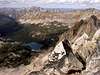
Mt. Cramer is the second highest peak in the Sawtooth Wilderness of Idaho. It is situated on the border between Custer and Boise counties, and is the highpoint of Boise County. The mountain can be climbed in a day on the east from the Hell Roaring upper TH. It can also be climbed as part of a backpacking trip from the east, south, or north. The east side of Mt. Cramer is drained by Hell Roaring Creek, the NW side by Redfish Lake Creek, and the SW side by the South Fork Payette River. Numerous beautiful alpine and subalpine lakes surround the mountain.
Getting There
From Boise, drive State Route 21 to Stanley. Turn right on SR 75. You may wish to acquire the parking pass at the Stanley Ranger Station before leaving town (see Red Tape). Drive south on SR 75 to about 12 miles from Stanley, and turn right on Decker Flat Road number 210. At .4 miles turn left on Hell Roaring Creek Road. The Hell Roaring lower TH is soon after this turn, but if you have 4WD and high clearance you can drive to the Hell Roaring upper TH at the end of the road and save around 4 miles of hiking each way. The upper TH involves a ford of Hell Roaring Creek, which in early season may be treacherous. Hike the trail to Imogene Lake, then leave the trail and hike cross-country on off-and-on use trails to lake 8733. Then climb NW to Cramer's east ridge and ascend the ridge until it ends. From there boulder hop to the summit. Round trip from the upper TH is around 16 miles.
Red Tape
A Sawtooth National Recreation Area parking permit must be purchased to park at the trailhead. The cost is $15 for an annual pass or $5 for a three-day pass. Obtain and complete the required Wilderness Permit at the trailhead.
When To Climb
The best time of year to climb Cramer is from July through September.
Camping
There are numerous campgrounds in the Sawtooth area. With the required Wilderness Permit, camping is also allowed in the Sawtooth Wilderness.
Mountain Conditions
To obtain current conditions you may contact the Stanley Ranger Station at 208-774-3000.
External Links

 38051 Hits
 88.07% Score
 27 Votes


Bob Bolton - Sep 27, 2004 2:38 am - Hasn't voted
Untitled CommentThanks! News to me - when we climbed Cramer in '91 we were told that Cramer was highest and Snowyside second highest. So that's what we set out to climb. I wonder if the wilderness boundary might have changed since then. Anyway, I'll duly correct the Cramer and Snowside pages.
Bob
mtybumpo - Sep 25, 2004 12:06 am - Hasn't voted
Untitled CommentMt. Cramer is actually the 2nd highest peak in the Sawtooth Wilderness. Thompson Peak at 10,751 ft. is the highest in the wilderness and in the Sawtooth range.
Bob Bolton - Sep 27, 2004 2:38 am - Hasn't voted
Untitled CommentThanks! News to me - when we climbed Cramer in '91 we were told that Cramer was highest and Snowyside second highest. So that's what we set out to climb. I wonder if the wilderness boundary might have changed since then. Anyway, I'll duly correct the Cramer and Snowside pages.
Bob