
-
 13011 Hits
-
 78.27% Score
-
 9 Votes
|
|
Mountain/Rock |
|---|---|
|
|
47.50352°N / 121.00222°W |
|
|
Kittitas |
|
|
Scrambling |
|
|
Spring, Summer, Fall |
|
|
7031 ft / 2143 m |
|
|
Overview

First False Summit

Scatter Peaks
Scatter Peaks is the name for the cluster of peaks on the ridge (highest point, Point 7031) just north of Van Epps Pass and south of Solomon Peak. Although easily overlooked, this peak requires a lot of good route-finding and is quite alpine in feel. In short, it is a lot of fun. One of the more interesting things about this scramble is that it is entirely off trail. There is absolutely no trail on this trip. You will drive on a logging road, find a ridge, and head up hill through forest to gain the ridge. From there, run out a beautiful ridge with views in all directions to a solid, Class 3 summit.
Note: Some consider Scatter Peaks to also be Van Epps Peak. There is some legitimate disagreement on this point, as others consider the high point south of Van Epps Pass to be Van Epps Peak. This is the inevitable confusion that occurs when peaks are named unofficially. Scatter Peaks does show up on the USGS map, and therefore is an official name. Van Epps Peak does not, however, and thus the confusion.
![False Summit]()
Atop First False Summit ![The Cradle from Scatter Peaks Ridge]()
The Cradle ![Skirting the Ridge]()
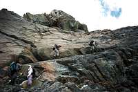
Skirting the RidgeDrive I-90 East from Seattle to Exit 80. Exit here and drive through the towns of Roslyn and Ronald and past the Salmon La Sac Guard Station. Continue about 8.5 miles to an unmarked logging road just before Silver Creek. You know you have gone too far if you pass the Scatter Creek trailhead (about 1/2 mile past the logging road). You've definitely gone too far if you reach Scatter Creek.
Drive up the logging road just a short distance (a couple of hundred yards) and park (Elevation 3,200 feet). Find the beginnings of the forested ridge just to your east and begin climbing through forest. The forest is dark, but never too hard to negotiate. You will begin to break out into the open about 5,500 feet. Once on top of the ridge, continue along the ridge crest directly east, passing over two false summits. The true summit is the third summit, and features an impressive looking rock face from the west. The climbing route lies directly up this face via a series of cracks and ledges. It is solid rock, but a fall here can lead to serious injury. Some parties may feel more comfortable with a rope for a rappel from the summit. Round-trip distance: 8 miles, Elevation gain: 3,600 feet plus minor ups and downs.
Getting There

Atop First False Summit

The Cradle

Skirting the Ridge
Drive up the logging road just a short distance (a couple of hundred yards) and park (Elevation 3,200 feet). Find the beginnings of the forested ridge just to your east and begin climbing through forest. The forest is dark, but never too hard to negotiate. You will begin to break out into the open about 5,500 feet. Once on top of the ridge, continue along the ridge crest directly east, passing over two false summits. The true summit is the third summit, and features an impressive looking rock face from the west. The climbing route lies directly up this face via a series of cracks and ledges. It is solid rock, but a fall here can lead to serious injury. Some parties may feel more comfortable with a rope for a rappel from the summit. Round-trip distance: 8 miles, Elevation gain: 3,600 feet plus minor ups and downs.
Update Courtesy of Gimpilator: Scatter Peaks can be accessed from the north using the Scatter Creek Pass trail. From his comments:
Use the same approach trail as you would for Solomon. From the pass, ascend the obvious diagonal ramp/ledge to the summit plateau just north of the peak.
To exit the ramp near the top, choose one of the short class 3 or 4 gullies up through the headwall which runs parallel the ramp. From the north, the summit block is solid class 3.
Here is a trip report.
![The West Face of Scatter Peaks]()
True Summit from West ![Climbing the West Face]()
Climbing the West FaceThe entire route lies in unprotected area, and no permits are required. The area where you park your car is not an official trail head, either, so you will not require a NW Trailhead Pass. However, there are some overzealous Forest Service rangers lurking in the area. Their agenda is to revert this area to wilderness, so they will give you a hard time for unnecessary marking. I'm not joking. We ran into one just north of here on Solomon Peak.
US Forest Service
Cle Elum Ranger District
West 2nd Street
Cle Elum, WA 98922
(509) 674-4411
To exit the ramp near the top, choose one of the short class 3 or 4 gullies up through the headwall which runs parallel the ramp. From the north, the summit block is solid class 3.
Here is a trip report.
Red Tape

True Summit from West
Climbing the West Face
Camping
This area is east of the Cascade Crest and is consequently very dry. After early July, there will be few snow banks, and there are no creeks on this trip at all. Camping is not really an option, unless you choose to climb this peak from the north (see Fish Eagle Peak) and camp at the headwaters of Scatter Creek. There are some very nice campsites there, and it is very scenic. Your climb will be more challenging from this direction, though.Contact Information
For those who wish to contact the Forest Service, use the following contact information:US Forest Service
Cle Elum Ranger District
West 2nd Street
Cle Elum, WA 98922
(509) 674-4411
gimpilator - Jul 16, 2017 1:46 am - Voted 10/10
Route VariationsIt might be worth mentioning that this peak has a very nice scramble route which ascends directly from the Solomon/Scatter saddle. Use the same approach trail as you would for Solomon. From the pass, ascend the obvious diagonal ramp/ledge to the summit plateau just north of the peak. To exit the ramp near the top, choose one of the short class 3 or 4 gullies up through the headwall which runs parallel the ramp. From the north, the summit block is solid class 3. Here is a trip report.
Snidely Whiplash - Jul 18, 2017 4:13 pm - Hasn't voted
Re: Route VariationsYes, have included it. Checked out your trip report on NW Hiker. Really well done, especially the Solomon-Harding traverse. Kudos!