

-
 7712 Hits
-
 83.1% Score
-
 16 Votes
|
|
Route |
|---|---|
|
|
46.63060°N / 12.31530°E |
|
|
Download GPX » View Route on Map |
|
|
Hiking, Mountaineering, Scrambling, Via Ferrata |
|
|
Summer, Fall |
|
|
Most of a day |
|
|
KS3-C |
|
|
Overview
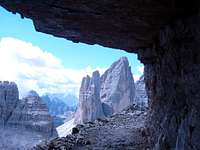
 The wild towers which Schartensteig / Sentiero dei Camosci negotiates The wild towers which Schartensteig / Sentiero dei Camosci negotiates |
During WW I the front line between Austian and Italian troops ran right through the middle of the the Sexten / Sesto Dolomites. Consequently the mountain range saw much and very heavy fighting, not least along the (former) border between Austria and Italy, which ran across Zwölfer / Croda dei Toni, Einser / Cima Una, Bödenknoten, Paternkofel / Monte Paterno and Drei Zinnen / Tre Cime. In consequence both armies established military positions on both sides of the frontline, supporting them with support trails, which run across precariously exposed terrain.
Paternkofel was one of the most coveted positions and it is no wonder that there are four routes, leading to the top of this mountain. Today three of these routes are vie ferrate of different difficulties while the fourth, probably the most dangerous of them all, is a steep scramble up a scree filled gully. All routes combine in Gamsscharte / Forcella dei Camosci, from where the common summit route heads up a vertical 10m chimney before running out on the steep summit ledges of the mountain.
The most picturesque of the routes follows the former border / frontline along Paternkofel's / Monte Paterno's east ridge negotiating about half a dozen saddles, which gave rise to its name: Schartensteig / Sentiero delle Forcelle or simply Saddle Route. Access to the starting point of the route, Büllelejoch / Forcella Pian di Cengia, is rather long so that most people use it as a descent route after climbing Paternkofel / Monte Paterno by one of the other routes.
Schartensteig / Sentiero delle Forcelle is a via ferrata and while it is rather easy it should not be underestimated. While the first half is a mere hiking trail the route gets very exposed once it reaches the mountains east ridge proper. In general it follows a system of ledges, most of which are 1 - 2m wide but for half a dozen times the route leaves the ledges to climb steeply to one of the many saddles. The via ferrata is well protected and offers no difficulty in orientation.
The most difficult section is the common section above Gamsscharte / Forcella dei Camosci. Here you have to scale a protected 10m vertical chimney before heading out onto the summit ledges. While in general the ledges are far from difficult, orientation is not straightforward. Moreover, there is a lot of scree on the ledges and you don't want to end up on a scree covered dead end above the south-east face of the mountain. But once you find your way away from this east face you are on safe ground heading for the surprisingly broad summit.
Getting There
 Handdrawn map of the Paternkofel / Monte Paterno Group.
The route starts at the pass Buellelejoch/Forcella Pian di Cengia at 2522m.
- It can be most easily reached from Rifugio Auronzo (large parking lot above a toll road) by following trail 104, which passes the south faces of Paternkofel / Monte Paterno, Passeportenkopf / Croda Passaporto and Bödenknoten. This access path takes bbetween 90 and 120min to complete.
- Another possibble route from Rifugio Auronzo leads across Paternsattel to Drei Zinnenhütte / Rifugio Locatelli and from there across Bödenalpe towards Buellelejoch/Forcella Pian di Cengia. This northern access takes some 2 1/2h to complete.
- A third route starts at Zsigmondy / Comici Hut to the east. The hut can be reached from Sexten / Sesto in about four hours while the ascent to Buellelejoch/Forcella Pian di Cengia takes little more than one hour.
Route Description
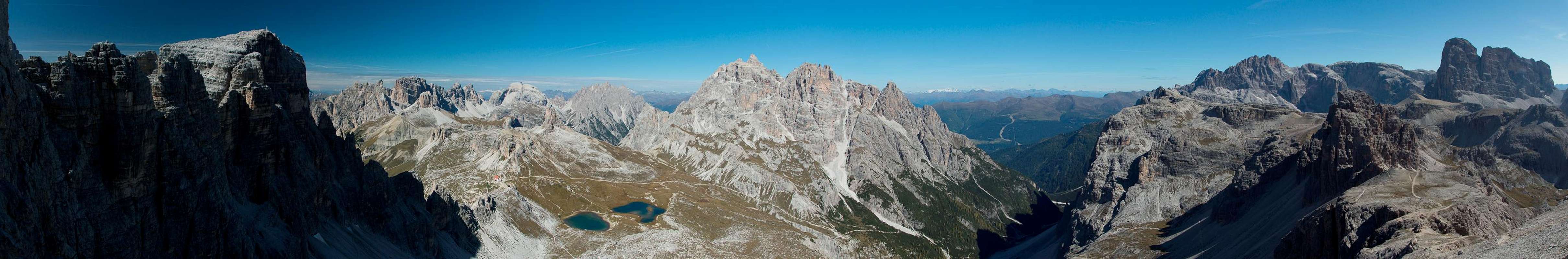
 Start-up view towards the northern Sexten / Sesto Dolomites from Büllelejoch / Forcella Pian di Cengia
- Start altitude: 2522m
- Summit altitude: 2744m
- Prevailing exposure: S
- Type: Ferrata Ksc-3
nbsp; - Protection: Well Protected
From Buellelejoch/Forcella Pian di Cengia the route heads south-west, aiming for the south slopes of Bödenknoten. BBefore you reach the slopes, however, you come across the remains of an old WW I fort, most likely of Italian origin. The route now leaves the broad ridge and cuts across grassy slopes, avoiding the rocky south face of Bödenknoten. It loses some 200m of elevation, turning the mountain's south face before heading back up onto the ridge.
 |  |  |
The route joins the ridge in a narrow saddle to the east of Bödenknoten, called Forcella dei Laghi, named after the view you get of Bödenseen / Laghi dei Piani. Turn west upon the Paternkofel / Monte Paterno East Ridge, which in this place still is broad and grass covered. Head up the slope until you get to a narrow cut, a glimpse of things to come. A protected section, complete with a steel ladder, reaches into and out of the cut.
 |  |  |
Follow the west ridge until you reach a first, round-topped highpoint. It is located a bit to the north of the route proper and offers a fine view into the north face of Paternkofel / Monte Paterno and the many towers on its east ridge. Turn back south onto the route, which quickly turns into a via ferrata. First you will come across a rock window, blasted out of the rock to make room for one of the military positions of WW I. Either climb through the window or turn around the rock on its northern side and you will reach the first of the protected sections.
  |
A ledge leads towards the south in a wide circle, passing severall cave entrances on the way. You'll soon reach the first saddle, without scaling too much elevation at first. As you head westwards you soon reach another sadlle, from where a wonderful view opens towards Drei Zinnen / Tre Cime. Looking north out of the V-shaped notch you'll see Haunold / Rocca dei Barranci and Dreischusterspitze / Cima Tre Scarperi.
 |  |  |
The path now scales a steep section, jumping down from ledge to ledge before reaching a small plateau with a good view towards Paternkofel / Monte Paterno. Soon the legde narrows again and heads through a wonderful set of heavily eroded towers, offering more perfect views onto Drei Zinnen / Tre Cime. After the next saddle a steep section takes you down onto another ledge (more wonderful views) and from there to the crossing of a deep but narrow gap. Remains of an old WW I bridge are still in place but a newer one has been installed to its side. Still, iit is a rather scary crossing as there are few footholds between the two bridges. After the bridges a flat section takes you directly to Gamsscharte / Forcella dei Camosci.
 |  |  |  |
Here three more routes join: from the North Ferrata de Luca / Innerkofler descends from a saddle, from the south Passeportensteig heads along a ledge towards the saddle while the regular route heads up a steep couloir from the south-east. In Gamsscharte / Forcella dei Camosci a fifth route turns west and heads up a steep section. After negotiating a 5m shoulder it heads up a 10m chimney to end up on another of the Paternkofel ledges.
 |  |  |  |
Here orientation gets tricky. There are multiple possible routes to scale the ledges and there are far too many cairns to mark a specific path. MMake sure you stay away from the east face of the mountain and head south-west instead. After stepping over several ledges the route (now again visible) turns north-west and heads for the surprisingly broad summit.
 |  |  |  |
Descent: Do not use Ferrata De Luca / Innerkofler - it is a one way route. Rather take the southern route towards Paternsattel, which negotiates ledges and tunnels on Passeportenkopf.
Use the south-western route only if you are familiar with scree descents. Though it is the only unprotected route it certainly is the most dangerous of all.
Essential Gear
 |
You need a full ferrata set. Besides regular hiking gear you need a harness and a self-belaying system (two biners on Y-shaped rope with braking system). You'll also need a helmet. If you plan to hike one of the other two ferrate bring a torch (better a headlamp) for the galleries.