
|
|
Mountain/Rock |
|---|---|
|
|
37.05320°N / 113.8222°W |
|
|
Washington |
|
|
Hiking |
|
|
Spring, Summer, Fall, Winter |
|
|
6789 ft / 2069 m |
|
|

Overview
Scrub Peak is also referred to as Scrub BM and draws the attention of that growing group of peakbaggers who chase the prominence peaks. It is found in the southwest corner of the state of Utah and is very accessible from the Nevada town of Mesquite or the Utah town of St. George.You can have breakfast in Mesquite, go visit this peak and return to Mesquite for a round of afternoon golf if you are so inclined or go shopping at the mall in St. George and have dinner at Ruby Tuesdays. Tucked away amidst the arid landscape of the Beaver Dam Mountains, Scrub Peak or Scrub BM (benchmark) is waiting for a visit. Most likely the mountain range was named for the small town that sits close to I-15 as there are certainly no beavers or their dams to be found in this mountain range.
Our mountain of interest, named Scrub BM Peak, probably after the vegetation found in abundance in this area, is located as mentioned earlier within the Beaver Dam Mountains of southwestern Utah, not far from the town of St. George. It is one of the prominent points seen on the skyline from St. George but locals would most likely not be able to point it out to visitors who asked. Scrub BM is one of Utah's top 100 prominence peaks coming in at number 77 on that list.
As is so often the case in the west, this peak does have a major flaw: A communications tower service road actually goes all to the way to the top of this peak but a gate bars entry so you cannot drive all the way to the top. Due to this gate, you will need to at least hike the last mile and a half necessitating a hike that gains a bit over a thousand feet in elevation. Of course that depends on whether you could drive the last mile or two since the road leading up to the gate is steep and nasty. Without high clearance and 4WD, you will have a longer hike to get to the top, perhaps all the way from the main dirt road that leads in from the highway. However, on one visit, the road was washed out at the bottom and it was necessary to hike from that point. The latest news is that the road is OK again.
Getting There
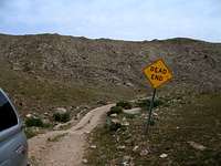
If coming from Las Vegas or St. George on I-15, turn off at exit 8 for Littlefield and Beaver Dam. Head north on the old highway 91 and drive about 9 1/2 miles (passing into Utah) and watch for a dirt road that takes off on the right side of the road. The turn off isn't signed although a short distance in on the dirt road you will note a sign for the Woodbury study area. One more sign with information about the Woodbury study area is passed and you won't see anything else signage wise on the remainder of the road. Proceed on towards Bulldog Pass but watch for a dirt road that takes off to the north at about 4200 foot of elevation (GPS lat/long nad 27 37.0158 -113.8157)A road grader had been there prior to our visit and so a small berm seemed to be blocking this dirt road but it was easy to punch across and gain access to the Scrub Peak road. Mileage wise it is probably about 6 or 7 miles from highway 91 (I forgot to set the odometer) but the elevation and GPS waypoint above will help you find the road (it worked for me). Once you find this lesser used track, you will know if you are on the right road when you see a "dead end" sign before you enter the canyon ahead. It seems out of place but it is telling the truth. As of 2011, the road is now gone, washed out by winter storms. Park at the "dead end" sign and walk in from there. You can follow the old road all the way to the summit but be prepared for this and plan on over six miles round trip and 2500' of elevation gain. Carry plenty of water if the days are warm. More on this information on "route information" described in a section below.
Update: thanks to information provided by SP member runbyu, the road was repaired and is again drivable up to the gate.
See the resource noted below as it has a map that you will find helpful. I find Huegels Utah Byways guide to be very helpful in my travels around the state of Utah.
Helpful resource
Route information
I mentioned in the getting there that the road to the summit is badly washed out at the beginning and that the best thing to do is park near where you see the 'dead end" sign and walk it from there.UPdate: Thanks to Runbyu, the road was reported to have been repaired during the summer of 2011 and is drivable up to the gate again.
A good resource for trip reports is found at peakbagger.
From "dead end" sign: 3.2 miles 2500'
When you reach the green gate, you are over halfway there. That gate area is where
folks with high clearance and 4WD vehicles could make it to before the road was wiped out. I doubt that the road will ever be rebuilt since the communications structure on top can be serviced by helicopter.
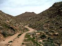
Just stay on the road all the way and you will not have to venture into the undergrowth and some good snake country. Be aware that this is rattlesnake country and cross country involves being snake aware. One of the snakes found in this area is the feared Mojave Green rattlesnake. I for one was happy to take advantage of the road, even though it lessens the attraction of a peak but then, many of the western peaks have had to suffer the fate of having communication structures put on their summit areas. If you prefer to not walk a road to the top, there are cross country possibilities available and a good study of a topographic map should provide the aid you would need.

Red Tape
The only red tape noted was the "no motor vehicles" sign placed on the gate.Evidently one of the communications structures on top serves the Mojave county sheriffs department (Arizona).
Camping & summer heat
You could car camp in many places as this is BLM land (use the leave no trace method). A simpler approach would be to spend the night in St. George or Mesquite or pick this up on the way to somewhere else. No campground nearby unless you use the one in the Virgin Canyon off of I-15.The summers in this area can be very temperate and temperatures can easily exceed 100 plus degrees. Plan accordingly and if you must do it in summer, carry plenty of water as you won't find any at all in this area.
Weather

Woodbury Desert Study Area
Home of the desert tortoiseThe Woodbury Desert Study Area (WDSA) was designated by BLM in June, 1977, and includes 3,040 acres. The WDSA is located in southwest Washington County with numerous washes that run to the south and west into the Beaver Dam Wash. The area is dominated by Joshua trees, creosote bush, and white bur-sage. This area contains many unique plant and animal species found nowhere else in Utah. The following species are found in or near this area: desert tortoise, desert iguana, desert night lizard, Mohave rattlesnake, speckled rattlesnake, desert kangaroo rat, desert glossy snake, western threadsnake, and Utah blind snake.
From 1930 to 1948, Angus M. Woodbury, and Ross Hardy, with the help of many students from University of Utah, Weber State College, and Dixie State College completed a study on desert tortoises within the area. This study has scientific significance because it contained the oldest population of marked desert tortoises and possibly the oldest marked populations of vertebrates in the United States. During this study, desert tortoises were removed from their winter dens by a person crawling back in the tunnel and removing the desert tortoise. Once removed, they were measured, weighed, and marked with paint or with a brand on their scutes (marginal bones on shell), and then returned to their dens. There were a total of 117 desert tortoises captured and measured during this study.
Once designated, the WDSA was fenced, and signs erected to provide protection to the unique flora, and fauna of the area. In 1998, the St. George Field Office established the Beaver Dam Slope Area of Critical Environmental Concern (ACEC). This ACEC is managed to protect and further the objectives of the Woodbury Desert Study Area, the Joshua Tree National Natural Landmark, and the maintenance of important desert ecosystems that include numerous other plants, and animals listed under state and federal procedures. The ACEC boundaries have been drawn to coincide as much as possible with the boundaries of the same unit in Arizona and Nevada. The entire ACEC links with Desert Wildlife Management Areas, refuges, and other ACECs in the remainder of the desert tortoise Northeastern Mojave Recovery Unit to provide a contiguous recovery zone of more than 1,750 square miles.
Thanks to the BLM for the above information
Additional information: LINK
Nearby peaks
West Mountain peak is another highpoint found in the Beaver Dam Mountains and could be combined with this one to make it a "twofer" day. For other nearby peaks, check out the possibilities on this Jarvis Peak Quad table as provided by Lists of JohnEric's trip report & maps
A nice resource can be found HERE at SP member Eric Willhites page.The fire
One thing I noticed on my recent visit to Scrub BM was the fire scarred trees. I hope to find out when this occurred and add this info to this section.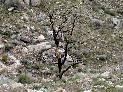
Local oddity
The lowest point in the state of Utah is found in the Beaver Dam Wash, not all that far from Scrub Peak. It is at an elevation of 2165 and a great map of the low point and the area can be found on page 178 of the book by Fred J. Nash,Utah's Low Points (A guide to the lowest points in Utah's 29 counties).
If you live in Utah, check your local booksellers for a copy of this unique book at Amazon.