|
|
Route |
|---|---|
|
|
29.28179°N / 103.30867°W |
|
|
Download GPX » View Route on Map |
|
|
Scrambling |
|
|
Fall |
|
|
A long day |
|
|
Class 3 |
|
|
Overview
This is a more direct route up to the summit that doesn't require climbing the South Gully all the way up to Peak 6490. Approximate route
Getting There
Start from The Window Trailhead in the Chisos Basin Group CampgroundRoute Description
Go down the Window Trail from the Group campground, and start crossing over to the mountain at the point at which the Window Trail intersects with the trail coming from the individual campground. You can take advantage of the clear(er) area that was formerly the site of the sewage lagoons.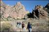 Approaching the South Gully Approaching the South Gully |
Start up the South Gully near 29.2817, -103.3089, heading in the most direct route possible toward the mini-saddle at 29.2839, -103.30795.
 Vernon Bailey from the Mini-Saddle Vernon Bailey from the Mini-Saddle |
Veer NNW off of the back side of the mini-saddle and down into the heavily-vegetated, tree-lined gully. You'll have to cross the gully pretty far to the right, as it cliffs out to the left. Once on the other side of the gully, start climbing the long scree slope to attain the large saddle behind the promontory at 29.2949, -103.3098.
 Looking Back at South Gully from the Saddle Looking Back at South Gully from the Saddle
|
From the saddle, descend down a steep-- but more vegetated and less loose-- talus/scree slope into another gully (foreground of the shot below.)
 Vernon Bailey from the Saddle Vernon Bailey from the Saddle
|
From there, ascend up the grassy Southeast Ridge of Vernon Bailey (to the left of the talus field.) Referring to the shot above, the ridge cuts diagonally left to right above the talus field. It isn't obvious in the picture, but there is an impassable ravine between the SE Ridge and the main summit, so it is necessary to attain the North Summit (upper right of above pic) first, then traverse over to the main summit (upper left of above pic.)
The SE Ridge is steep but is mostly hikeable and doesn't require scrambling except to get on top of a few short, rocky ledges. There is nothing exceeding Class 2+ in difficulty and no significant exposure.
Descend the way you came up.