
-
 16585 Hits
-
 73.06% Score
-
 3 Votes
|
|
Route |
|---|---|
|
|
36.44034°N / 105.0499°W |
|
|
Hiking, Mountaineering |
|
|
Spring, Summer, Fall |
|
|
Half a day |
|
|
Class 3 |
|
|
Note: Unfortunately, hiking into the Philmont backcountry is reserved for Scouts and Scouters on official itineraries. It is not generally open to non-Scouts/non-Scouters, or to Scouts and Scouters who aren't on official itineraries.
Overview
Shaefer's Pass is the common juncture for crews returning from treks to hike to the top of the Tooth of Time on their last day. It provides ready access from many camps, include Shaefer's Pass, Clark's Fork, Ponderosa Park, North Fork Urraca, and many others. This description assumes that the hiker has found his way to Shaefer's Pass.Getting There
Getting to Shaefer's Pass will depend on the specific Philmont trek itinerary. Generally, there are four trails into the pass; from the north (Clark's Fork, etc), from the west (Black Mountain), from the south (North Fork Urraca Camp, etc) and from the west (the Tooth itself, which is the route you might take if you visited the Tooth on the first day of your trek).Route Description
The route will take you along the Tooth of Time Ridge. From Shaefer's Pass up to and around Shaefer's Peak is a class 1 hike on a modest uphill grade (about 500-feet maximum vertical ascent).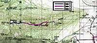
Marked USGS quad chart of the area.

View to the north during the hike.
Essential Gear
1. Although you shouldn't have any difficulty following the trail, you'll want to carry the Philmont Scout Ranch South Country section map.2. If you're continuing back to main camp along the ridge or via the Stockade Trail, you'll have lots of exposure to the afternoon sun and will want to drink lots of water. Take plenty of filled water bottles, or perhaps even a collapsible dromedary. Refill with water at Shaefer's Pass Camp; there isn't any other water supply along the ridge (Some seasons Shaefer's Pass Camp is dry, so check before departing your camp the evening before!). If you do carry a dromedary, you can sling it under a walking stick and let two people carry it until it's used up (you'll want it to be empty and stowed before hitting the class 2 section past Shaefer's Peak).
3. You'll want some means to treat the water at Shaefer's Pass.
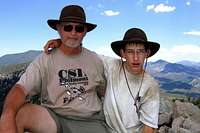
Check out all the gnats on my shirt!
4. A hiking stick or trekking poles might come in handy for crossing some of the Class 2 rocky terrain. Once you've dropped your pack for the final Class 3 ascent, however, it's best to just scramble using hands and feet.
5. A small daypack to carry water, camera and other essentials to the top of the Tooth after you've dropped your backpack.
6. Depending how long you'd like to linger at the top, you might want to have some insect repellent – in warmer seasons there will be plenty of ladybugs (not too annoying) and gnats (quite annoying). Descend even as few as 10-feet to get away from the little buggers!