
|
|
Mountain/Rock |
|---|---|
|
|
33.58578°N / 116.3763°W |
|
|
Riverside |
|
|
Scrambling |
|
|
Winter |
|
|
5141 ft / 1567 m |
|
|
Overview
Sheep Mountain is a lonely rarely visited desert peak in the Santa Roas Mountains. It is part of the San Bernardino National Forest and the trail lies entirely within the Santa Rosa Wilderness.
The peak was named for the Peninsular Bighorn Sheep that were once ubiquitous throughout these ranges. It is doubtful any sheep ever make their way to this remote section of the mountains any longer. However, dogs should be leashed, it is a requirement of the wilderness, and care should be taken to respect and preserve the home of these endangered creatures.
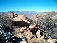
The trip follows the Cactus Spring Trail for four miles to Cactus Spring. After that off-trail route finding is necessary. From the spring a wash leads slightly northeast to the shoulder of the mountain. A use trail exists and it is easy to find a cairn or two, but staying on the trail is all but impossible. It is so infrequently used that the summit register dates back to the 1960's and there aren't very many names in the book.
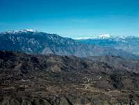
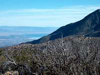
This is a good trip for beginners new to off-trail navigation. Sheep Mountain is easily noticeable and it is not hard to find the summit, even though there are a couple of false summits. Toro Peak and Martinez Mountain dominate the immediate skyline which makes navigation easy. San Gorgonio and San Jacinto are always visible to the West, so a person with any trail sense should be able to get back and forth rather easily.
A GPS is a great thing to have along just in case, and topo maps area necessity.
Getting There
Drive on Highway 74 east past the intersection with Highway 243 at Mountain Center for approximately 21 miles. Turn right onto paved road 7S09. There is a sign for the Ribbonwood Equestrian Park, the Sawmill Trail and the Cactus Spring Trail. Turn right and follow the road to the large parking area.
7S09 is approximately 8.75 miles east of Highway 371
Alternately, from Palm Springs take Highway 74 west for nearly 15 miles to 7S09. Turn left and park in the lot.
The trail converges with many dirt roads and leftover mining relics
Red Tape
The trip takes place entirely within the Santa Rosa Wilderness, but the area is so remote that no permits are necessary. Signing in at the trailhead is required, however.
An Adventure Pass is needed for parking in most of Southern California's National Forests. The passes cost $5 daily and $30 annually. A second vehicle pass can also be purchased for an additional $5 Dollars.
Adventure Pass
Camping
Pinyon Flat Campground is located just across the Highway from Forest Road 7S09.
Thomas Mountain has many sites and is located to the west on Thomas Mountain Road.
Lake Hemet is 15 miles east and has campsites available year round.
San Jacinto State Park has a variety of campgrounds for all types of uses.
San Benrardino National Forest Campgrounds
External Links
Best Hikes With Dogs Southern California by Allen Riedel
Lake Hemet
San Bernardino National Forest
Santa Rosa Wilderness