
-
 20517 Hits
-
 81.83% Score
-
 14 Votes
|
|
Mountain/Rock |
|---|---|
|
|
36.09910°N / 81.80134°W |
|
|
Caldwell |
|
|
Trad Climbing |
|
|
4592 ft / 1400 m |
|
|
Overview
Ship Rock is a classic climbing destination in North Carolina. The wonderful metasandstone rock here offers a variety of climbing including steep faces, roofs and cracks. Climbing grades vary from 5.5 to 5.13a. It is a popular area and a destination for many NC climbers seeking the more moderate (cooler) summer temperatures found in the Blue Ridge. Most routes here are trad with bolts supplementing gear. See "Getting There" for important info about approach and descent.
 |
Getting There
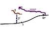
*Update* During the floods of 2004, two sections of the parkway have been closed for repair. See Mountain Conditions section for info to contact the BRP about road closure. Ship Rock is located on the Blue Ridge Parkway. It is located near Mile post 303. To access this rock, park at the Rough Ridge parking area which is about 0.5 miles North from Ship on the Parkway. DO NOT PARK IN THE GRASS. Alternate parking is available South of Ship Rock on the parkway at the next available turn off. Walking is nearly the same from both areas. Approach, from the Rough Ridge parking area, walk South on the Parkway for approx 0.5 miles. You will cross a bridge, and Ship will be up to your right. Follow the climbers trail that skirts right along the wall, going over boulders up to the main climbing area. You will come up the trail near the Gumfighter area, continue to the left along the base of the wall to access the main routes. To access the Uppier Tier climbs continue to the right of the wall near the Gumfighter area and follow a climbers trail that cuts up and then left. Descent: to descend Ship Rock you need to rappel. Walking off the top is frowned upon and devestating to the ecology of the area. There are several main rap stations. For the main tier climbing area, rap from shuts above Boardwalk or Harpoon. For the upper tier, rap shuts are located above Lost at Sea, Edge of a Dream, and Castaway.
 |
Red Tape
No Permits are required. No entry fees, or parking fees are required. *Important* *Important* Ship rock lies on the boundary of The Nature Conservancy land. Conservation at Ship Rock is of upmost concern. Do NOT park your car along the road. There are two parking areas, located on the parkway on both sides of Ship Rock. The first at Rough Ridge near mile post 303, which is NORTH of Ship Rock. Most people park here. If that parking area is full continue SOUTH on the parkway to the next parking area past Ship, Little Wilsons. Do NOT cut across the summit of Ship Rock to set up Top Ropes. Do NOT try to access Ship Rock via the Tanawha Trail. Access is spelled out in the "Getting There" section. Also, see the Overview section to see details about descent off the rock. The National Park service has requested that climbers only tred on the bare rock surfaces and adhere to established trails. As of current, no new fixed protection is to be added to Ship Rock. Access to this area is a very touchy subject. Do your part to ensure the survival of Climbing/Hiking/Mountaineering in areas such as Ship Rock. *Important* Recent floods from Hurricans in 2004 has changed and damaged much of the wilderness in the surrounding area. Contact the Forest Service or NPS for guidelines and restrictions. (especially around the Linville Falls area)
 |
When To Climb
Ship Rock is primarily a Spring, Summer, Fall climbing area. It is a prime location during the summer to escape the heat that is associated with the South Eastern US. Spring and Fall are also good seasons, but temps may vary during this time making climbing less than ideal. During the winter it can get bitterly cold, with ice forming on some routes. Additionally, during wintery weather the National Park Service closes this portion of the Parkway so you cannot drive to Ship.
Camping
Camping is not allowed on Ship Rock, or in the parking areas. There are two pay camp grounds in the general area. The closest is at the Boone Fork camping area, located on the Blue Ridge parkway near mile post 298 (approx 5 miles North on the parkway from Ship Rock) The second camping area is at Linville Falls and is approx 13 miles south on the Parkway (mile post 315)
Mountain Conditions
For Current condtions near Boone NC: www.booneweather.com Blue Ridge Parkway info line: (828)298-0398
 |