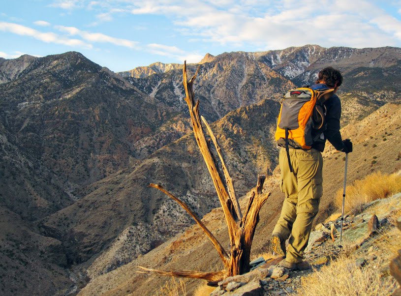
Death Valley is well known as having the lowest point in North America in Badwater Basin at nearly 300 feet below sea level. Much less well known are the impressive Panamint Mountains that rise abruptly from Badwater's western margin. Although the Panamint range isn't at the top of every peak-bagger's list, it probably should be as they are noteworthy for many things.
At 11,049 feet, Telescope Peak is the highest point in the Panamints as well as in the entire Death Valley National Park. Telescope's height and geographic position provide a very unique opportunity to gaze down on the lowest point in North America (Badwater), turn 180 degrees and then look up to the highest point in the contiguous U.S. at Mt. Whitney (14,505 feet) topping the distant Sierras.
The Panamints also have a rich human history. With several reliable water sources, an abundant supply of pine nuts, and cooler high-altitude temperatures, the Panamints were a favorite summer camp for the Timbisha (Shoshone) Indians that have inhabited Death Valley for more than 1,000 years. The Timbisha struggled for recognition after their lands were subsumed by the National Park (originally declared a National Monument by Hoover in 1938), but still today, many of the Timbisha Tribe reside at a small reservation at Furnace Creek.
Next came the prospectors and miners. Over several decades, many millions of dollars in gold were extracted from Panamint Mountain mines near the now-abandoned towns of Harrisburg, Skidoo, Panamint City, and Ballarat.
The sheer isolation of the Panamints have also harbored its fair share of outlaws, bandits, and other recluses. None are more famous than Charles Manson himself who hid out with his "family" of murderous misfits at Barker Ranch in the southern part of the range. This is where in a series of raids in 1969-70, law enforcement captured Manson and much of the family for arson and theft. Only later did authorities realize they had captured a mass murderer. As recently as 2008, authorities searched the Panamints' foothills near Barker Ranch for additional Manson Family victims. Sadly, the Barker Ranch burned down in 2009.
1968 photo of Barker Ranch. Manson payed "rent" by giving the owner a Beach Boys gold record--a gift to Charlie from drummer Dennis Wilson. Source: L.A. Public Library.
The most alluring thing about the Panamints to the hard-core hiker, however, is the staggering vertical relief from Badwater to Telescope Peak. Do the simple math and you are looking at well over 11,000 feet of relief in only about 15 miles! That's tough to beat anywhere in North America, especially if you're talking about tackling that kind of terrain in a single day.
For example, the trail to Mt. Whitney can be hiked in a day, but it amounts to only 8,500 feet of vertical gain.
Badwater to Telescope easily beats out the much more famous single-day grinder "Cactus to Clouds" near Palm Springs which racks up 10,400 feet in 17 miles.
Nothing in Utah comes close. The trail from Henry's Fork to Kings Peak (Utah's highpoint) rises a paltry 5,252 feet in 12 miles. Even if you climbed Utah's most popular thigh-burning climb--Mt. Timpanogos--from the very bottom of the mountain at American Fork, you're looking at a gain of only about 6,700 feet.
What about all of Colorado's mighty 14ers? The Colorado Rockies are huge but they sit on a pretty lofty base. The trail to Pikes Peak has the biggest vertical gain of all of Colorado's 14er climbs, but it amounts to only 7,400 feet.
The most popular route up the Cascade's Mt. Rainier racks up an impressive 9,000 feet, but that is spread out over multiple days.
The West Buttress route to the top of Mt. McKinley (Denali), the highest point in all of North America, involves a whopping 13,500 feet of climbing, but again, that is spread out over multiple days.
Heck, the vertical gain from Everest's base camp to the highest point on Earth is about 11,330 feet--nearly identical to Telescope's vertical rise. That's pretty good company.
Adding to the degree of difficulty is the fact that there is no trail up the east side of the Panamints. This has not deterred masochistic hikers looking for the rare chance to bag more than 11k of continuous climbing in one day. An unofficial route taking advantage of an old mining road at the beginning, and a short section of trail near the very top (there's still a long and grueling cross-country scramble in the middle) has emerged over the years.
The route begins at Shorty's Well (elevation -262 feet) on the western edge of the Badwater flats and follows the old mining road up a massive alluvial fan into Hanaupah Canyon. The well was located by prospector Alexander "Shorty" Borden who also built the road which eventually leads to his mine workings in the South Fork of Hanaupah. At Shorty's mine, the route begins climbing in earnest as it makes its way to the Panamints' summit ridge. From there, a well-maintained trail leads the final 1.5 miles to Telescope.
Before making final preparations for my own attempt at Telescope, I called Death Valley's visitor center to inquire about snow conditions. I wasn't expecting good news. After all, we're talking about an elevation of 11,000 feet in mid January. So I was ecstatic when a ranger explained that Telescope had just a skiff of snow and that conditions on Telescope could hardly be better for this time of year.
My plans for Telescope would differ from most trip reports I'd found online in two ways. First, I planned to bike up the old mining track up Hanaupah Canyon as far as I could rather than walking. Second, since I wouldn't have a shuttle vehicle, I'd have to do the hike as an out-and-back. Most hikers, after bagging the peak, make the short and easy stroll to Mahogany Campground (elevation 8,133 ft) and then shuttle back to Shorty's Well, cutting out most of the knee-pounding descent.
With gear packed, GPS programmed, and a note left detailing my route, I embarked on the 6-hour drive to Death Valley.
Arriving at Shorty's Well at 8 pm, I set my alarm for 3:30 am and crawled into my sleeping bag. Unfortunately, due to the fact my kids had recently watched Little Mermaid, and that I was well aware that I was 200 feet below sea level, the mental soundtrack for the evening was Sebastian's "Under the Sea." I drifted off to sleep with thoughts of a perfectly executed plan to the summit, occasionally interrupted by Sebastian's baritone, Under the sea, under the sea, darling it's better down where it's wetter, under the sea! Annoying.
It's no surprise that I woke up 5 minutes before my alarm went off. I had my game face on all I could think about was execution and efficiency. The only times I was allowing myself to stop was to get food/clothing in and out of my pack or to go the bathroom. And I absolutely had to control myself from wasting precious time taking pictures.
I started pedaling and gained my first of over 11,000 feet at 4 am sharp. A fairly bright half moon provided just enough light to negate the need for bike lights.
The road climbs about 2,000 feet in 4.5 miles up the moderately sloping fan to the mouth of Hanaupah Canyon. The road was a little bumpier than I anticipated, but I was still able to cruise along easily in the middle ring.
As I rolled along on Shorty's road under the lonely moonlight, I reflected on some the things I'd read about this hardy miner. Arriving in Death Valley in the 1920s, this WWI vet prospected vast areas of the park until discovering a silver-rich vein in Hanaupah Canyon in the early 30s. Reportedly, it took ol' Shorty only about 6 months to build the 9-mile road over rugged terrain to his mine. He accomplished this alone at the ripe age of 65 using only hand tools and a mule! Now that's toughness.
Source: Pomona Public Library.
At the crest of the fan, the road drops quickly into the active alluvial valley flooring Hanaupah Canyon. From there, the road continues at a similar grade, although the road surface deteriorates significantly as you begin to encounter boulder fields and sections of deep, loose gravel. More than once I accidentally diverged up branching stream channels since they were essentially indistinguishable from the road. I was forced to dismount a couple of times when my tires bogged down in deep pea-sized gravel.
After 7.5 miles and more than 3,200 feet of climbing, conditions were bad enough that I figured I'd be better off walking. After stashing my bike behind an SUV-sized boulder, I noticed the sun getting ready to crest. I looked down at my watch--it was nearly 7:30! I'd been biking for 3.5 hours but I swear it felt more like 1 or 2 hours tops. Weird Twilight Zone-type stuff. Regardless, I was hoping to be at Shorty's mine at sun up, so I was already officially behind schedule.
After about a mile of jogging through Hanaupah's narrows, I found the road completely obliterated by flash floods of years past. Continuing up the boulder-strewn stream bed, I soon heard the gurgle of the small stream issuing from Hanaupah Spring and I knew Shorty's mine was around the corner.
It was now nearly 8:30 am and the sun was brushing the top of the Panamints with its golden tone. Four and half hours in, I had gained nearly 4,000 feet in 9 miles. Only 7,000 feet to go!
The small but reliable stream flowing from Hanaupah Spring near Shorty's mine.
Daybreak in Hanaupah Canyon.
Bird's-eye view of Shorty's mine from the steep ridge on the opposite side of the canyon.
Opposite of Shorty's mine, a broad, treeless ridge climbs to the top of a massive east-west-trending ridge dividing the North and South Forks of Hanaupah Canyon. This is the beginning of the most difficult stretch where there is no trail (a fleeting hiker-made path is encountered occasionally) as you climb 6,400 vertical feet in less than 4.5 miles.
I kept a deliberate and steady pace, but was careful not to push too hard. I've never used trekking poles for climbing a mountain before, but I figured any stress I could transfer from my legs to my arms would be a big plus in this situation.
Once on the intervening ridge top, the grade slackens a bit and a sparsely populated pinyon and juniper forest is encountered. The hiking on this ridge is not too steep, is easy to follow (simply stay on the highest ridge), and is quite enjoyable. Still, with tiring legs, and a whole lot of mountain still above me, about midway up the dividing ridge, I had that am-I-really-going-to-be-able-to-finish-this? moment. I sat down for the first time, snacked on potato chips, and reasoned that since I had no soreness or tendonitis issues, I could afford to push the pace a little to get back on schedule.
I pulled some rocks up to prop up my trekking pole as a tripod, when I was greeted by this little guy.
A white secondary quartz vein cuts across dark metamorphic rocks. Similar outcrops are what would have grabbed the attention of prospectors like Shorty Borden.
At about elevation 6,700 feet, my route brought me to a very steep and fairly vast talus slope. My choices were to continue on the most direct route up the scree or to detour around. I really wish I had detoured. The bottom of the scree field consists of stable, cooler-sized angular blocks that appeared to make a decent climbing surface. This proved true for a while, but the scree material got progressively smaller and looser and I ended up wasting substantial energy as I struggled to find solid footing without sliding back downhill.
The upper slopes of Telescope Peak as they appeared from about halfway up the E-W ridge. Note the unusually small amount of snow for mid January.
Above the talus, there's one last push up a mostly treeless slope to the top of the main summit ridge and junction with the official Telescope Peak Trail. A dead, twisted, and very prominent Limber or possibly Bristlecone pine marks this junction.
I arrived at this point (just under 10,000 feet in elevation ) at noon--exactly 8 hours into the climb. My goal was to summit between noon and 1 pm. With a comparatively easy 1.5-mile and 1,100-vertical-foot trail walk left, I knew I had it in the bag and that I was pretty much back on schedule.
After a very calm day thus far, the wind really picked up on the summit ridge. With cooler temperatures at high altitude and the steady wind, I'd guess the windchill got down into the 30s. But being so close to my goal, I refused to stop and waste any time fishing out my windbreaker and overgloves. As long as I kept moving, I knew I'd stay warm enough.
Large gnarled tree found where the route joins the official Telescope Peak Trail.
Limber and Bristlecone pines are common on the summit ridge above 10,000 feet.
There were just a few inches of snow on the north-facing slopes which were not a problem. There were occasional icy patches on the trail where previous hikers had really packed the snow down, but these slick patches were easily avoided. The wind was strong enough to knock me off course a couple of times along the last 100 yards of trail which are directly on the ridge line.
Looking east toward Badwater and the Black Mountains. My car is a tiny dot down there somewhere.
Stepping on top was one of the sweetest victories I can remember. With just a few scattered high-level clouds, views stretched forever (never-ending views are how Telescope got its name).
It was 1 pm. It took me exactly 9 hours to reach the top. In good position time-wise and only downhill left, I lounged around for a good half hour, snacked, looked over the hiker log books, and took plenty of photos. There was just enough of a depression amongst the rocks on top to block the relentless wind.
View to the south along the Panamints' summit ridge.
A USGS reference cap that points to the actual Telescope Peak benchmark, which I never did find.
View north along summit ridge.
My legs felt worn and tired--although no major muscle soreness--so I felt comfortable jogging down the trail at a good pace. If there ever was an ultimate test for my recovery from a serious IT band injury I suffered more than a year ago, this nearly 8,000-foot descent back to my bike was it.
My legs felt somewhat rejuvenated with the downhill range of motion and I felt like I was flying down the mountain. I sought out the same loose scree fields that I had avoided hiking uphill, as they allowed me to glide down the mountain with less impact on my knees.
Reaching Shorty's mine just before 5 pm, I decided I had just enough daylight to check out his workings.
Shorty Borden's mine never was much of a success. His road up the bottom of the canyon was prone to destructive flash floods, plus, the ore shipping costs proved to be higher than his mine's assay values. Still, as I sat near his mine enjoying views of this deep and peaceful canyon, I couldn't help but think that Shorty was perfectly content here anyway.
Taking a closer look at Shorty Borden's silver mine in Hanaupah Canyon.
Shorty's mine is in great condition considering the fractured nature of the bedrock in the area. Still, several fresh expansion cracks along the adit walls indicate rock fall and partial collapse could occur anytime.
I reached my bike at 5:45 pm and started the fast and bumpy ride back to Shorty's Well. It was nice to give my legs a rest and just coast, but I still had to stop a couple of times to rest my arms which were cramping from the constant jarring from the bumpy road and constant squeezing of brake levers.
I pulled up to my car at 6:30 pm. After 30 miles and 23,000 feet of elevation change, my adventure clocked in at 14.5 hours.
One lucky SOB. I noticed this tube aneurysm as I loaded my bike.
It felt great to be back on flat ground, and I immediately started to think about where to camp. The easiest thing to do would have been to stay put and spend another night at the well, but all I had to eat was Gu and granola bars. That wasn't going to cut it. I craved some serious protein! I knew I had to get to Furnace Creek to pork out, but there was one last thing I had to do before leaving Badwater.
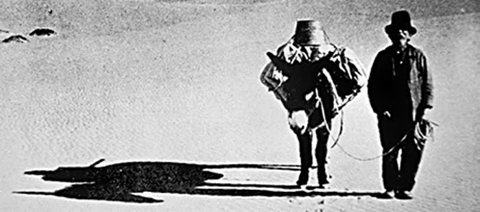
Buried 250 feet below sea level are the remains of one of Death Valley's most colorful characters, Frank "Shorty" Harris. Described as the last of the Old Timers, Harris made several prominent gold discoveries in the early 1900s, chief among them the Rhyolite/Bullfrog district and the Harrisburg district which bears his name. He lived for the thrill of the hunt, and never really profited from his discoveries. He had a really bad habit of celebrating his finds a little too much at the nearest saloon and not sobering up until after the best claims had been staked. Next to Shorty lies his dear friend and fellow prospector Jim Dayton, buried exactly where he died of exposure in 1898.
It was a surreal experience to wander the desert in the dark, alone, amongst the greasewood, and clumps of up-heaved salt for those nearly forgotten graves.
The headstone's epitaph, written by Shorty himself, reads:
Here lies Shorty Harris, a single blanket jackass prospector 1856-1934
The grave site of Shorty Harris and Jim Dayton at the bottom of Death Valley.
Shorty Harris, self-proclaimed "single-blanket jackass prospector," roams Death Valley's hostile deserts in search for gold. NPS photo.
I was in luck. The 49er Cafe at Furnace Creek had exactly what I was looking for: a half-pound burger with bacon piled high and topped with a fried egg. I could have ate two or three, but I didn't want to risk shocking my still-somewhat-fragile digestive system.
After calling my wife and telling her about my successful climb, I drove a few miles up the nearby Hole-in-the-Wall Road, pulled over, opened the sun roof, reclined the seats, and gazed at the stars until I promptly fell asleep.
First thing in the morning, I took the short drive through scenic 20 Mule Team Canyon. Star Wars fans may recognize this as the setting for Jabba the Hutt's Palace in Return of the Jedi (click here for a very cool site about Star Wars in Death Valley).
Road to Jabba's Palace.
I ended my Death Valley trip with a short drive to Dante's View, high in the Black Mountains across the valley from the Panamints. From here, you get a great perspective on just how massive Telescope Peak is.
View from Dante's View (elevation 5,475 feet).
Telescope has got to rank up there with the Grand Canyon's Rim-to-Rim-to-Rim and the Trans-Zion as possibly the hardest and most memorable single-day suffer-fests in the West.
That evening I was wandering around in the middle of the valley around sunset and a while after taking photos, and as I started walking back to my car I noticed a headlamp proceeding down the lower reaches of the mountain at what had to have been much faster than hiking pace. I assumed somebody had used a bike to make the Telescope ascent a bit quicker, and thought that was a pretty good idea. Whaddya know.
Great TR and accomplishment, hope to replicate your feat one of these days, and will keep the bike option in mind.
As long as you're gaining elevation using your own power, I don't discriminate against using a bike. I read more than one TR of people complaining about the "long boring walk" up the road and that they would skip it if they did the hike again. Biking that road by moonlight/bike lights was pretty fun.
Seems like the day after I get back from climbing something no matter where it is there is someone elses TR featured on SP of the same mountain. I just climbed Telescope a couple days ago on Presidents day. A little more snow than you had but still only a few inches. What a dry year...and a gorgeous summit view!
Excellent job taking the SW2T hike 2 steps further with the bike approach and the full descent. Very nice for you that your IT band survived as well. I stopped at The Barker Ranch in 2007 on a trip through Goler Wash over Mengel Pass and into Butte Valley. I even followed others into the bathroom where authorities found Charlie inside the sink cabinet. It was nothing short of creepy. Personally, i was glad to hear that it burnt down. I much prefer to hear of contributions of men like Shorty or Manly or you in the history of Death Valley.
Snowslydder - Feb 24, 2012 11:41 pm - Hasn't voted
I just did this hike on saturday and there was more snow but it wasnt too bad until about 500 ft from top. I have even more respect for yer trip after doing the hiking trail, yer a str8 beast!!
I enjoyed reading your trip report, the pictures brought back memories of my climb from -282 out on the salt flats to the top and back in 1985. I remember when planning the climb that hiking on the road up the aluvial fan would be the easiest part of the hike but when I actually was doing it it seemed like the hardest, who actually does a long climb by walking miles on a perfectly good road that one could drive (or bike) on that, as you say, would be "cutting out most of the knee-pounding descent." Not getting any sleep also made for a very long day.
Parents refers to a larger category under which an object falls. For example, theAconcagua mountain page has the 'Aconcagua Group' and the 'Seven Summits' asparents and is a parent itself to many routes, photos, and Trip Reports.


Comments
Post a Comment