
|
|
Mountain/Rock |
|---|---|
|
|
48.25000°N / 120.425°W |
|
|
8690 ft / 2649 m |
|
|
Overview
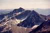
Star Peak is the most foudroyant mountain in the entire Lake Chelan-Sawtooth Wilderness. It is also the highest peak in the wilderness outside of nearby 8,795-ft Oval Peak. However, the mountain is the highest point directly situated on 20+ mile long Sawtooth Ridge. (Oval Peak is located a few miles away on an outlier ridge.)One could suppose there are five distinct ridges to the mountain--the Northwest Ridge, the Southwest Ridge, the curving South Ridge, the Southeast Ridge, and the East Ridge--thus giving it its stellate name. Or perhaps the name could be attributed to its stature alone--it being the "star" of the wilderness area east of Lake Chelan. Star Peak is characterized by a rugged east side; precipitous northwest, north, and northeast sides; broad south-facing slopes; and long southwest and southeast ridges. It also holds a rock glacier in an eastern cirque. This rock glacier looks like nothing more than a striated talus basin and slope from a distance, but up close the features of a rock glacier would probably be more apparent. 7,290-ft Bernice Lake--one of the highest lakes in the state--sits in a high cirque on the Southeast Ridge about 1.2 miles from the summit.
 |  |  |  |  |
Getting There
To get to Star Peak, drive to the Methow River valley in north-central Washington and then up the Twisp River Road. At 10.8 miles on this road, turn left onto Buttermilk Creek Road and go 4.5 miles to West Fork Buttermilk Creek Road. This road heads west. At the wye, take the left (upper) road. Shortly you will arrive at the West Fork Buttermilk Creek Trail No. 411. Take the well-maintained trail 9.5 miles to 7,480-ft Fish Creek Pass on the northwest side of the mountain. The Greentrails map for the area apparently shows an upper trail that more or less parallels the W. Fork Buttermilk Trail and then joins it closely east of Fish Creek Pass. This very obscure and unmaintainted trail starts on or near Scaffold Ridge about 7 miles northeast of Star Peak. After a few miles, the trail can really only be tracked by following blazes. One could also approach the mountain from the other side from a Lake Chelan ferry drop off either at Prince Creek or Fish Creek (Moore Point), but these will not be any shorter than east side approaches. |  |  |
Climbing Routes
There are two non-technical ways (class 3 max) to climb Star from the vicinity of Fish Creek Pass. The first and easiest way to climb Star is to drop down from the pass into the head of the East Fork Fish Creek valley, skirt Star Lake, and ascend scree slopes and a steep, loose gully to the Southwest Ridge of Star. Look for a faint path up through the scree. Once on the ridge, turn left and head back northeastward then eastward on alternately blocky and sandy terrain to the summit.The second and perhaps a little more interesting way would begin about a mile before reaching Fish Creek Pass. When a view from the trail of Star's northeast side first offers itself, leave the trail and cross the valley southward. But before you leave the trail, look up onto the East Face of the mountain. If clouds don't obscure it, you will see an obvious ramp diagonaling up from lower left to upper right (to the saddle between main and northwest summits). To access this ramp, you basically want to aim for a timbered knoll (small ridge) just north of the long East Ridge. This knoll is at the far end of a long talus slope. At or just before the timbered knoll, turn right. The ramp should present itself to you. In early season, you'll want an ice-axe for this. Otherwise, it's just more talus to the summit ridge. One could go up this way and go down via the Southwest Ridge route or visa versa.
Rock climbing routes (to the 8,155-ft northwest summit):
1. The Northeast Buttress (left corner of North Face) looks like mostly class 4 with some class 5 for 500+ feet. Could be slabby. Hardest part is probably mounting the buttress down low
2. The North Face (above the ice patch) looks like unprotectable 5.8 or higher for 500+ feet
3. The Northwest Ridge (starting from Fish Creek Pass) is a knife-edge until it steepens sharply for the last couple of hundred feet. This route was climbed by John Mailhioti and Rolf Larson on September 7, 1997. They reported it as Grade III, Class 5.7. Some manky rock but a good location.
4. The concave Northwest/West Face (above Star Lake) would be upper class 5 climbing of 300+ feet. Like the North Face, smooth rock may inhibit adequate protection
It would be a fun area to explore for rock climbing adventures.
 |  |
When To Climb
The mountain could be climbed year-round. In the winter and early spring it would be an excellent ski tour to the mountain. Skiing the mountain itself may be more involved. In summer or early fall it's an all scree and talus hike, but some northside rock routes might be interesting--particularly along the Northwest Ridge directly from Fish Creek Pass or up the Northeast Buttress.Camping
There are some campsites along the trail, but the terrain is pretty open so you could camp almost anywhere. Care should be taken not to trample native vegetation. The open basin northeast of the peak and east of Courtney Peak would be a nice place to camp.Red Tape
Permits are not really required in the region though one of those annoying Trail Park Passes may be requested.Mountain Conditions
It can be hot or cold or in between in the Lake Chelan-Sawtooth Ridge Wilderness. Ordinarily, you won't get much frontal rainfall as the wilderness is far east of the Cascade Crest. What does blow over is usually highly dissipated or scattered once it gets to the area. However, the area is prone to thunderstorms in the summer. I have been snowed on in the area in early September.Localized Forecast