
-
 17652 Hits
-
 83.1% Score
-
 16 Votes
|
|
Mountain/Rock |
|---|---|
|
|
48.81200°N / 116.621°W |
|
|
7355 ft / 2242 m |
|
|
Overview
Pyramid Peak, an aesthetic formation of slabby granite, is an Idaho scrambler's paradise. With a variety of routes ranging from second class to fourth class with little to significant amounts of exposure, this peak provides a real wilderness experience along with some excellent Selkirk granite. The peak resides in a remote section of northern Idaho, near the Canadian border. Part of the appeal is that you will rarely see another person past the alpine lake campsites. This mountain is climbed very seldomly. The experience of being in an area that forbids motorized vehicles, is fairly close to a major population center, yet has not been overdeveloped is a rare one these days. The Idaho Panhandle National Forest area provides this.
The history of climbing this peak, along with others in the area, was never documented. Without a developed trail or guidebook providing significant detail, the area sees little attention. Scrambling in this area is not covered online or in book form at all. The guidebooks for technical 5th class alpine rock cover only the peaks on the west side of the Selkirk divide.
The information in this page is entirely from my 2 experiences with the mountain. It is not based upon anything else. While this peak is not the highest in the general vicinity, it's symmetry and variety of srambling routes make it the most significant one, in my opinion.
 |  |  |
Getting There
From I90, head north through Sandpoint until just past Bonners Ferry. 13.5 miles north of Bonners Ferry, turn left unto highway 1. After 1 mile, turn left on Wallen Road. Follow this road for about 3 miles, passing over the Kootenai River via a raised bridge. The road tees with the Westside Road. Make a left here and follow it for about 2 miles on paved roads. You will come to a fork where it is paved to the left and dirt to the right. Stay to the right and follow this for 2 more miles. Turn right on Forest Service Road #634 and drive 8 miles to the end parking area.
Depart on the trail at 5,405 feet for Trout Lake. After about 3/4 mile, you will come to a fork. Make a left here toward Pyramid Lake if you attempting the ridgeline traverse from Ball Lakes. Ball Lake is about 3/4 of a mile beyond Pyramid Lake. If you are attempting the Northeast Ridge directly, turn right at the fork, the left after 1/4 mile. For the traverse it is nice to do it in 2 days with a camp at lower or upper Ball Lakes. There is some really good 4th class scrambling just above upper Ball Lake to keep you busy.
 |  |  |  |
Routes Overview
| Route | Summer Class | Winter Slope | Approach | Exposure | Quality of Rock |
|---|---|---|---|---|---|
| Northeast Ridge | 4th Class | 45 degrees | Long Mountain Trail | Moderate | Very Good |
| East Face | 2nd Class | 30 degrees | Long Mountain Trail | Low | Poor |
| Southeast Ridge | 3rd & 4th Class | 35 to 45 degrees | Ridgeline Traverse from Ball Lake | Moderate | Moderate to High |
| South Face | 2nd Class | 30 degrees | Ridgeline Traverse | Low | Poor |
| Northwest Ridge | 4th Class | 70 degrees | Long Canyon Creek Trail | Very High | High |
| North Couloir | 3rd Class | 60 degrees | Long Canyon Creek Trail | High | Moderate |
 |  |  |  |  |
Red Tape
There are no permits required to hike or climb here. The forest service road is open all year, but is not plowed during the winter. No parking passes are required either.
The Selkirk Forest Service requires that no motorized vehicle or cart be operated on any trail at any time. Overnight campers at the alpine lakes must use designated campsites. Please observe all regrowth areas. Practice leave-no-trace camping ethics.
When To Climb
The "snowless" season is early July through mid October. The forest service road is nice and smooth, and can be done in a car. High clearance vehicles are not required.
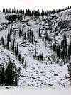
In Decmber of 2002, I attempted a winter ascent of the Northeast Ridge of Pyramid Peak. My 4 wheel drive car made it only 4 miles up the 8 mile FS road. Keep in mind that tire chains or snowmobiles may be required to reach the trailhead. The snow in the area is renowned for its skiing. It is very powdery, definately bring snowshoes.
 |  |  |
Camping
There are some really nice alpine lakes in the area including Trout Lake, Pyramid Lake, Upper Ball Lake, and Lower Ball Lake. An overnight stay here along with a dip in the lake or some fishing makes a very enjoyable weekend trip.
Other activities in the area
There is an absolutely enormous amount of granite boulders laying everywhere around this mountain, and around the trails on the approach. If you are a boulderer, seeking a new undeveloped area to set your own routes, I highly recommend this place. Most of the rocks are 8 to 20 feet high.
Fishing is also very popular in the alpine lakes. We saw several parties make good catches.
External Links
- Pyramid Pass Trail
Describes the trail to Pyramid Pass, which is the trail you start on for Pyramid and Ball Lakes. Further links take you to that trail description.