-
 15971 Hits
-
 82.76% Score
-
 16 Votes
|
|
Mountain/Rock |
|---|---|
|
|
28°S / 28.00000°E |
|
|
10387 ft / 3166 m |
|
|
Overview
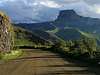
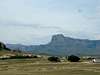
The Drakensberg is a wilderness area and World Heritage Site. Located in the Northern Drakensberg, the Sentinel Peak area is almost the only way to experience the soaring heights of the "High" 'Berg without having to spend one or two days ascending one of the mountain passes up from the "Little" 'Berg. There is a very scenic and easily accessible road ending in a secure car park, enabling the hiker to reach an altitude of almost 2,600m without having taken a step. A R5 toll is charged for the use of this road. (It is possible to walk from Witsieshoek Mountain Resort to the Sentinel Car park although this can take the better part of half a day.)
The Zulu name for this impressive peak is Ntabamnyama - the Black One. It is the most frequently climbed peak in the Drakensberg, mostly due to the easy access from the Sentinel car park. Provided that you know where to go, the Standard Route provides a quick and easy descent for the harder routes.
From the car park hikers can also ascend an easy path - with a short, steep zig-zag section - before contouring along the base of a line of sheer basalt cliffs. The escarpment, Mont aux Sources and the amphitheatre are accessible from here by a series of chain ladders. These chain ladders can be very daunting for those who do not have a head for heights. Descending the ladders is more difficult than ascending and there are particularly tricky in windy or icy conditions. Queues of climbers can build up at the chain ladders during main holidays seasons.
The top of the escarpment affords views of the Tugela Falls and because it is easily accessible makes it a popular spot. Unfortunately it also means that this area of the escarpment is very badly littered and aesthetically unpleasing. There is a hut on the escarpment above the chain ladders but on my last visit it was severely ruined and damaged. Tent camping is recommended (make sure your tent is able to withstand strong wind) and water is readily available from the streams that feed the Tugela Falls.
 |  |  |  |  |
Red Tape
No red tape. Small fee for entry.
ALWAYS ALWAYS ALWAYS sign the mountain register both before leaving on a trip and on your return. This is the only way to ensure that the rescue team knows where to find you if you get on the mountain in bad weather conditions. The weather changes extremely rapidly on the berg - do not underestimate the importance of completing the mountain register.
Fires are strictly prohibited throughout the berg.
 |
Mountain Conditions
The Drakensberg lies in a summer rainfall area (October to March). This is the wetter time of year and some climbs are not suitable to be attempted in wet conditions. Thunder storms are common in the afternoons preceded by hot humid conditions. The best months for climbing are April through to September. During this time stable weather is usually experienced with warm sunny days and cold nights. Note that snow can also occur during this time.
Like most mountain areas, climatic conditions can change very suddenly and hikers must always be prepared for sudden changes in the weather. The seasons are not as clearly marked as in the Northern hemisphere. Generally, we have a long summer and short winter. The Berg can at times be windy, especially in August, or misty, especially in summer.
Summers (October/November to March) are characterised by warm sunny days with showers and thunderstorms. The thunderstorms can be very violent and spectacular. The waterfalls and rivers are full and the grasslands and vegetation a lush green.
Winter (late June, July and August) is very dry with the days still often at an agreeable 20-22 C but cold nights with frost on the ground and occasional snow.
Miscellaneous Info
The upper Berg was formed by the outpouring of molten lava, giving rise to what is today called Stormberg Basalt. Many climbs tend to have rock located between broad grass ledges. The rock is also formed into rounded overhangs, blocks and gullies, making the climbing often quite awkward. Rock quality is often poor making climbs off of recognised routes risky.
The rock located at low altitudes is generally the worst while that near the summits is often quite acceptable.
Protection - A selection of wired stoppers and small hexes are useful. Self-adjusting cams (friends etc.) are extremely useful and more adept than hexes at fitting into the unusual cracks of the basalt rock. A selection of a few knife-blade and channel pegs are usually also carried.
A 1:50 000 topographical map of the area is available at the Sentinel Car Park office. Be aware though that due to the high metal content in some of the Drakensberg rocks compasses do not always work accurately in the berg.
Mountain Rescue
Medical emergencies in the Drakensberg fall under the authority of the Provincial Emergency Medical Rescue Service (EMRS). However, due to the hazards and technical difficulties encountered in the Berg, rescues are carried out in conjunction with the Kwa-Zulu Natal Section of the Mountain Club of South Africa.
This rescue team is both highly efficient and well-equipped and are supported by helicopters from the South African Air Force's 15 Squadron. The cost of the rescue is covered in the permit you buy when you enter the park.
External Links
- Link to Geocaching.com entry
Log your climb here too.
- Mountain Club of South Africa (Natal Section)
- About the Drakensberg
- Tugela Falls
- Climbing ZA
All the info on climbing in South Africa - conditions, guide books, photos, news etc
- Paradigm's shift
See this page for photos and an RD of the Paradigm's shift rock climbing route on the Sentinel