
-
 34725 Hits
-
 83.69% Score
-
 17 Votes
|
|
Mountain/Rock |
|---|---|
|
|
40.53330°N / 111.734°W |
|
|
11154 ft / 3400 m |
|
|
Overview
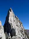
With an elevation of 11,154 feet, South Thunder Mountain is only 4 feet higher than her sister summit of North Thunder Mountain, which is located approximately 1 mile to the north, connected by a long and rugged ridge.Both South and North Thunder are greatly over looked, with their proximity to the much more popular Lone Peak to the southwest, and the Pfeifferhorn to the east.
Long approaches, tedious scrambling, routefinding, and significant elevation gain ensure that South Thunder is a challenging hike, regardless of the route chosen.
This is a seldomly visited summit, despite the fact that the mountain directly overlooks the Salt Lake valley with a population of over one million.
USGS Quads:
• Dromedary Peak, Utah (1:24k)
• Draper, Utah (1:24k)
• Salt Lake City, Utah (1:100k)
 |  |  |  |  |
Getting There
Getting there from I-215From the 6200 South exit I-215, head East and South on 190 2± miles to the intersection with Big Cottonwood Canyon, continue straight on 210 through the light (South) which is also Wasatch Blvd. For 2.1 miles to a traffic light, stay right towards La Callie for another 1.1 miles to the intersection with 9800 south, continue straight of Wasatch Blvd. for another 0.7 miles. The parking area for the trailhead is located on the East side of the road (10245 south Wasatch Blvd).
Getting there from I-15
From Exit 298 on I-15 proceed east on 9000 south for 5.9 miles to Wasatch Blvd. 9000 south turns into 9800 south while starting to ascend near a gravel bank. Turn right onto Wasatch Blvd and travel for 0.7 miles. The parking area for the trailhead is located on the east side of the road (10245 south Wasatch Blvd.).
In addition to the Bells Canyon approach, other possible routes to South Thunder include Chipman Canyon, Lake Hardy, or the Beatout (approaching along the ridge from the Pfiefferhorn).
 |  |  |  |  |
Red Tape
South Thunder Mountain is located in the Lone Peak Wilderness Area. No fees or permits are required for hiking in this area, but the following regulations apply:• No motor vehicles, mechanized equipment, hang gliders, or bicycles
• Group sizes exceeding 10 persons
• Camping within 200 feet of lakes, trails, or other sources of water
• Camping for more than 3 days at one site
• Short cutting trail switchbacks
• Disposing of garbage, debris, or other waste
The Bells Canyon trailhead passes through a residential area, so please show respect to the property owners.
 |  |  |  |  |
Camping
There are numerous possibilities for camping in Bells Canyon. Water is available year round in the canyon - treat before drinking.Mountain Conditions
The 7-day forecast below is for the Wasatch Front valleys - expect considerably colder and more severe weather in the mountains.