
|
|
Mountain/Rock |
|---|---|
|
|
40.80940°N / 109.9735°W |
|
|
12276 ft / 3742 m |
|
|
Overview
Eccentric Peak (benchmark name) is located in the eastern portion of the Uinta Mountains. The peak is located nearly due north 40 miles of Roosevelt, Utah and is the county high point of Daggett and Uintah counties. It is relatively easy and can be done with the family, as this is one of the easiest of the 12'ers in the Uintas and Utah. The high point is marked with a BM (brass cap) and a stone wind shelter. Interestingly, there are actually two benchmarks on this same mountain, located a very short distance apart. For this reason, the peak is also known as Chepeta Peak.
This peak is a worthwhile destination, but it isn't near as dramatic as many of the other Uinta Peaks, and is amoug the least dramatic of the high peaks in Utah. It is perhaps the most popular of the peaks in the eastern Uintas, but only because it is a county highpoint.
If not for the county high pointers and the close proximity to Chepeta Lake the peak would probably be visited by only a few each year. The more scenic route is from the north and Tamarack Lake.
The Uinta Mountains are one of the few mountain ranges in North America that run east to west rather than north to south. Within the Uinta Mountains are about 2000 lakes, and some 900-1000 are full of trout. Along with the San Juan Mountains in Colorado, the Uinta Mountains have more contiguous area above timberline than any other area in the Continental United States. This is a beautiful area with many lakes, meadows, wildflowers, and some rugged peaks. Solitude is usually easy to come by once you leave the popular fishing holes behind.
The Uinta Mountains are very rugged in the northeast section. Beginning at Hayden Peak and east to Mount Lovenia, the Uinta Mountains are not unlike the Tetons or other ranges. East of Lovenia, the peaks are more gentle, with a few rugged peaks (i.e. Red Castle and Henrys Fork Peak) scattered about until you are as far east as the Henrys Fork/Kings Peak area. East of Kings Peak, the Uinta Mountains become very gentle and the peaks are very rounded with only a few scattered cliffs about.
Utah's 12,000+ Foot Peaks With 200+ Feet Prominence
Utah's 12,000+ Foot Peaks With 300+ Feet Prominence
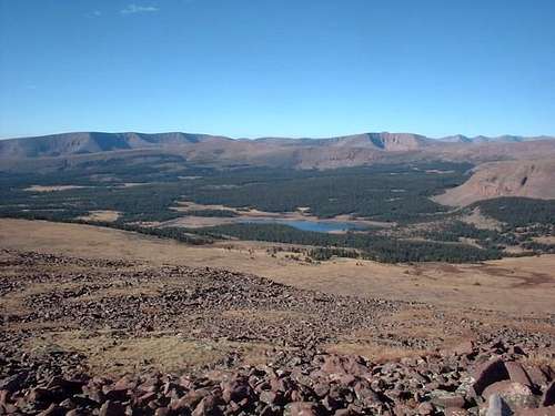 Looking down at Chepeta Lake from near the summit.
Getting There
Chepeta Lake Trailhead
(These directions are from SP member Grandwazoo)
Starting in Roosevelt, Utah: “A”
All distances are running mileposts, and are in reference to the intersection of US40 (200N) and State Route 121in Roosevelt, Utah; this is the point where US40 makes 90 degree turn at a traffic light.
M.P. 0.0 - head west on 121
M.P. 0.2 – turn right at “Y”
M.P. 9.4 - Stay Straight at intersection in Neola
M.P. 16.6 - Stay left, Road leads off to the right. (getting there “B”)
M.P. 17.8 - Stay right on paved road, dirt road goes Straight
M.P. 21.7 - Turn right onto FR 117 and cross stream
M.P. 21.9 - Turn right on to Elk Horn Loop road.
M.P. 25.4 - Stay Straight, Lower Pole Creek is on the right
M.P. 33.2 - Stay Straight, Pole Creek campground on the right
M.P. 33.9 - Turn left onto FR 110, Chepeta Lake
M.P. 37.4 - Turn right on hairpin, left goes to West Fork TH
M.P. 44.1 - Stay Straight, Chepeta TH on the left.
M.P. 45.6 - Trailhead at Chepeta Lake.
Starting in Roosevelt, Utah: “B”
All distances are running mileposts, and are in reference to the intersection of US40 (200N) and State Route 121; this is the point where US40 makes 90 degree turn with a traffic light.
M.P. 0.0 - head east on US40
M.P. 5.0 - Turn left onto 5750 east, West Jr. High (school on left, S.W. corner of intersection)
M.P. 12.9 - Straight through intersection, 121 turns right
M.P. 15.0 - Straight through intersection, 121 turns left
M.P. 17.6 - continue through town, This is the Town of Whiterocks
M.P. 20.8 - continue straight, left turn goes to Uinta (getting there “A”)
M.P. 24.1 - Turn left, straight takes you to the ranger station
M.P. 25.1 - continue straight, left turn goes to Elkhorn
M.P. 33.4 - continue straight, left turn goes to Dark Canyon
M.P. 38.9 - Turn right onto FR 110, Towards Chepeta Lake - left goes to Pole Creek CG
M.P. 42.9 - Turn right on hairpin, left goes to West Fork TH
M.P. 49.6 - Stay Straight, Chepeta TH on the left.
M.P. 51.1 - Trailhead at Chepeta Lake.
Even though option "B" is longer the choice is a better one.
The additional miles are on paved roads. "A" is a good change of pace for the return drive if one so indulges (a little rougher)
Both routes can be achieved by car but not by one of mine, I would recommend four-wheel drive or a car you don't care about.
Spirit Lake Trailhead
From Fort Bridger (WY), exit off I-80 and take Highway 414 south through the tiny communities of Mountain View and Lone Tree. At Lone Tree, the highway truns east. Follow the highway (SR 414) to between mile markers 132 and 133 and turn south onto FR 221. This is just before McKinnon. Stay on FR 221 all the way to Hickerson Park. At Hickerson Park, turn south on FR 001 and drive it seven miles to Spirit Lake. The road is usually in fair condition for passenger cars.
2021 updates from SP member vanman798:
There are two "trailheads" in this area. One is on the east side Spirit Lake about half way down it's North to South length and goes east over the ridge and down to Daggett Lake. That is NOT the trail head to start at if you intend to climb Eccentric Peak via Dagget Peak. Instead, keep driving until you drive past the Spirit Lake Campground entrance and locate another trailhead at the southwest end of the campground. This trail goes to Tamarack Lake. Park here and head south east at 125 degrees into the trees - there is no trail to follow from the parking lot to the summit of Daggett Peak.
An interesting note: The two trailheads are about 3.5 miles apart as the crow flies. To drive from one trailhead to the other is something like 7-8 hours as there are no roads crossing the core of the Uintas!
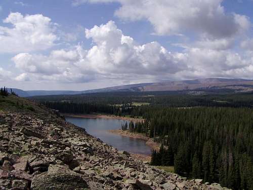
 Just below Papoose Lake
Routes Overview
The Chepeta Lake Route is by far the most popular route and the one described in the two county point guidebooks out. This is the easiest and shortest route. The route heads north to between Papoose and Moccasin Lake and then northeast to the gentle summit. This route is about 5.2 miles round trip with 1700 feet elevation gain.
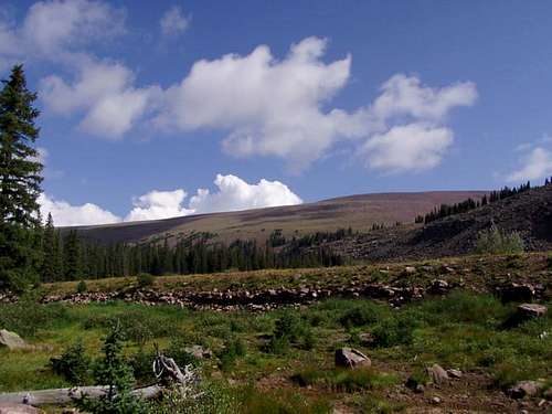
 From the steepest part of an otherwise almost entirely flat hike.
The Spirit Lake Route is slightly longer than the Chepeta Lake Route, has only a bit more elevation gain and passes over a sub-peak. This route is only slightly more difficult than the Chepeta Lake Route and is very easy for an off-trail route.
It is somewhat a mystery to me as to why the Spirit Lake Route is not the most popular route because it is much more scenic and the access road is generally better. From the trailhead, this route heads SE up to the ridge and then follows it SW to a sub peak ("Dagget Peak"). From Dagget Peak, the route follows the gentle ridge SE and then east to the summit of Eccentric. This route is about six miles round trip with 2500 feet elevation gain.
When to Climb
July through September is the normal hiking/climbing season here. Mosquitoes can be especially thick in July down by the lakes, but since these routes are mostly on ridges, they usually aren't too bad.
In winter, forget about getting to Chepeta Lake Trailhead. It would probably take more than a week just to get to the trailhead and back! The Sprit Lake Trailhead is more accessible in winter, but still quite a walk. You will have to walk an extra 12 miles each way to the trailhead. Logging companies sometimes keep the road plowed to Hickerson Park, about 7 miles each way from the trailhead, but there is a locked gate. If you call the forest service (801-784-3445) they may be allowed to loan you a key to the gate. Plan on a three-day trip in winter.
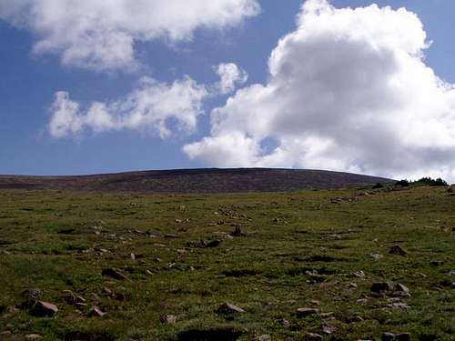 The Flat Summit in August.
Red Tape
No permits are required.
Camping
Chepeta Lake Route
The last formal campground is Pole Creek CG, located at M.P. 33.2 (Getting there “A”), or take a left at M.P. 38.9 (Getting there “B”).
Spirit Lake Route
There is a campground at Spirit Lake, right at the trailhead.
The peak is located within the Ashley National Forest so there is ample camping along most of the dirt roads leading to the trailheads.
There are also toilet facilities at the trailheads.
Mountain Conditions
Weather Forecast for Central Uinta Mountains
Here are some average highs and lows from the 12,139 foot elevation (3700 meters) in the Uintas (about the same altitude as the summit):
| MONTH | HIGH | LOW |
| JAN | 14 | -1 |
| FEB | 16 | 1 |
| MAR | 19 | 4 |
| APR | 27 | 11 |
| MAY | 35 | 18 |
| JUN | 45 | 25 |
| JUL | 55 | 32 |
| AUG | 53 | 31 |
| SEP | 45 | 24 |
| OCT | 34 | 15 |
| NOV | 22 | 8 |
| DEC | 17 | 3 |
paulhbrown - Oct 21, 2020 10:34 am - Hasn't voted
Road in good shapesee my comment re condition of the road from the south, 21 Oct 2020.
vanman798 - Sep 7, 2021 4:33 pm - Hasn't voted
Spirit Lake Route - Real numbers and info....There are two "trailheads" in this area. One is on the east side Spirit Lake about half way down it's North to South length and goes east over the ridge and down to Daggett Lake. That is NOT the trail head to start at if you intend to climb Eccentric Peak via Dagget Peak. Instead, keep driving until you drive past the Spirit Lake Campground entrance and locate another trailhead at the southwest end of the campground. This trail goes to Tamarack Lake. Park here and head south east at 125 degrees into the trees - there is no trail to follow from the parking lot to the summit of Daggett Peak. After about a half mile of climbing you should notice a small lake to the west (hikers right). This small lake is split by the north to south border of Summit and Daggett counties. Continue going up hill through the trees in the same SE direction until in about another mile and a half you reach the Daggett Peak North East ridge. Turn right and head SW up the ridge gaining about 850 vertical feet to the 12,046 summit of Daggett Peak. The summit of Daggett peak is approximately on the Daggett Co, Duchesne Co line at N 40.81532 W 109.99413, The total elevation gain from the parking lot is just shy of 1900 ft, and the distance covered to Daggett Peak is 3.5 miles. From Daggett Peak to Eccentric Peak is another 2.2 miles and you have to drop down to 11,200 feet (an 846 foot drop), and the climb up to 12,276 feet (1076 feet). Head SxSE (149.8°) to the 11,200 foot saddle, then climb east (80.9°) to Eccentric Peaks survey monument located at N 40.80934 W 109.97405. In September 2021 when I was there the survey monument on Eccentric Peak had a rock wall stacked around it and was stamped with the incorrect elevation of 12,280 feet. See this photo https://www.summitpost.org/eccentric-peak-survey-monument/1063213. In total the round trip hike is 11.4 miles with 3,800 feet of elevation gain. With a steady pace, and a rest on both Daggett and Eccentric peaks a reasonably fit hiker will need six hours to complete the round trip. 150 yards North East ( 52.5°) of the Eccentric Peak survey monument is another survey monument labeled Chepeta Peak and stamped with a 12,267 foot elevation. The Eccentric monument is a polished aluminum color and the other one is gold in color. This hike is a bit of a slog and not all that scenic. Have fun!
Scott - Oct 22, 2021 7:06 pm - Hasn't voted
Re: Spirit Lake Route - Real numbers and info....Thanks for the updates! It has been more than 30 years since I have climbed the peak! I'll incorporate much of the updates you have so thanks.