
|
|
Mountain/Rock |
|---|---|
|
|
38.09400°N / 119.677°W |
|
|
Toulumne |
|
|
9935 ft / 3028 m |
|
|
Overview
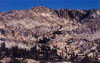
Schofield Peak is located in the scenic northwest boundary country of Yosemite National Park. It sits at the south end of a granitoid cirque that encompasses Upper Peninsula Lake. As is typical of the mountains north of Yosemite, Schofield Peak lacks the dramatic steep wall faces that are commonly found farther to the south. However, this area is speckled with beautiful subalpine lakes, grassy meadows, wildflowers, and thickets of Pine and Hemlock trees.For climbers seeking solitude, Schofield Peak is an ideal destination. Although it is only 4 miles off of the Pacific Crest Trail, few people seem to stray off the beaten path to explore this area. One reason for this is it is 18 miles from the nearest trailhead! However, if you are hiking the PCT, or exploring northern Yosemite, this is an easy climb with nice views of the area. There are several easy class II routes to the summit, plus numerous other nearby peaks that can be climbed during the same visit.
 |  |  |
Getting There
Schofield Peak is in such a remote area, there are several possible trailheads to start from, each somewhat equidistant from the peak. Selecting a trailhead will depend on the season and your overall itinerary.1) Hetch Hetchy Reservoir is accessible off of Route 120 near the western entrance to Yosemite National Park. From Hwy 120, drive north on Evergreen Road. Turn right on Hetch Hetchy Road and drive for 9.1 miles until you get to the parking area at O'Shaughnessy Dam.
Matthew Holliman notes that Hetchy Hetchy Road is only open at certain times, usually 7am-8pm. Check the NPS site for current times.
Take the trail north to Jack Main Canyon until you reach the PCT. Continue north for 1.5 miles, then follow the outlet stream coming from Otter Lake to the west. (18 miles total)
2) Kennedy Meadows Resort is located off of CA Highway 108, just west of the Sonora Pass. The trailhead is located at the end of the parking area for the Kennedy Meadows Resort. Overnight parking at the resort lot is $5/night and can be paid at the resort lobby. Alternatively, free parking is available at the signed forest service "trailhead" parking lot, which is located about 3/4 mile from the trailhead.
Kennedy Meadows also operates a pack (horse) station. They will let you park overnight for free (and shower for free upon return) if you pack in with them one-way*. They also have rental cabins, a supply store, small restaurant and saloon. You can hike the (22 miles) to Schofield Peak, or have Kennedy Meadows take you to Maxwell Lake, leaving you with a 7.5 mile hike.
Follow the Huckleberry Trail all the way to Maxwell Lake (14.5 miles). This is a great place to camp. Next, continue south on the Huckleberry trail for another 1.5 miles and take the trail split south to Twin Lakes. Upon reaching Upper Twin Lake, take the trail to the west which follows the northern shore of Lower Twin Lake. The trail disappears but follow the outlet stream of the Twin Lakes until the profile of Haystack Peak comes into view to the south. Follow the outlet stream of Peninsula Lake up until you reach the Lake. Schofield Peak overlooks the far (south end of Peninsula Lake.
3) Leavitt Meadows Pack Station is located on CA Hwy 108, just west of I-395. Free parking is available in the trailhead parking area near the campground, north of the pack station. You can hike the 26 miles to Haystack Peak, or have Leavitt Meadows Pack Station drop you off at the northern Yosemite boundary, leaving you with an 11 mile hike. Rates for horses are available on their web site*.
Follow the West Walker River trail south until you reach the Cascade Creek trail. Follow the Cascade Creek trail until it joins the PCT. Take the PCT south until you get to Grace Meadow. At the south end of Grace Meadow, about 1.25 miles past Chitteden Peak, follow the outlet stream of Otter Lake to the west. The ascent begins just a mile NW of the lake.
4) The Leavitt Lake trailhead is only accessible with an SUV with high clearance and 4-wheel drive. Leavitt Lake road is located 3.8 miles east of the Sonora Pass off of CA Hwy 108. It's 3 miles to Leavitt Lake over very rough terrain and a couple of stream crossings. Free parking is available on the north side of the lake. Follow the Leavitt Pass trail south, up and over Big Sam, for 10 miles until you reach Emigrant Pass. Take the trail split to the south. Near Grizzly Meadow, take the trail split to the SW that leads through Horse Meadow. You'll reach the Huckleberry trail at the far end of Horse Meadow. Head south for .75 miles and take the trail split to Twin Lakes. Follow the directions above to Peninsula Lake. (21 miles total)
5) The Cherry Lake trailhead is located in the SW corner of the Emigrant Wilderness Area and is accessible earlier in the season than the other trailheads. From Groveland, take Hwy 120 east for 13.6 miles to Cherry Oil Road 1N07, just past the South Fork of the Tuolumne River. Follow it 5.3 miles to a junction with paved Hetch Hetchy Road, then go left on the poorly paved road 17.6 miles to dirt Cottonwood Road 1N04. Head east and drive over the Cherry Lake dam. Continue on Road 1N14 for 1/2 mile. Turn left at the fork in road onto Road 1N45Y. Look for the trailhead sign for old Kibbie Ridge Trail. Parking is free.
Follow the Kibbie Ridge trail north and eventually towards the east past Lord Meadow until you get to the south end of Huckleberry Lake (19.3 miles). Follow the trail on the south side of the lake for another 3/4 mile to the trail split to Fawn Lake. Continue past Fawn Lake on this poorly maintained trail until you reach Peninsula Lake. If you lose the trail, just follow the inlet stream to Fawn Lake to its point of origin at Peninsula Lake.(23 miles total)
* Call well in advance to reserve horse and guide if you decide to pack in with either one of the pack stations.
Red Tape
Free wilderness permits are required for overnight stays in both the Emigrant Wilderness Area and Yosemite National Park.Depending on your point of entry and which direction you are coming from, call one of the following ranger stations for wilderness permits.
- Groveland Ranger Station - for Cherry Lake trailhead: (209) 962-7825
- Hetch Hetchy Entrance Station: (209) 372-0200
- Summit Ranger Station, for Sonora Pass trailheads: (209) 965-3434
- Bridgeport Ranger Station, for Sonora Pass trailheads: (760) 932-7070
Food Storage
Bear cannisters are required by federal law in most areas of Yosemite National Park. Click here for current information.
When To Climb
The climbing season varys each year depending on how much snow the area receives during the winter months. Hwy 108 closes during the winter, making winter access from the north more difficult. The distance of Schofield Peak from the nearest trailhead adds additional complexity to winter climbing. So typically the most popular time to climb the mountain is from June through October. Your best bet for winter access is to start from either the Hetch Hetchy or Cherry Lake trailheads, which are the lower elevation entry points.Camping
There is very good camping on the west side of Peninsula Lake and north side of Otter Lake. Although both lakes were stocked with trout many years ago, I do not think either lake holds fish anymore. The camping at Upper Peninsula Lake is not as good.Mountain Conditions
Call any of the ranger stations listed above for current conditions.
The following links provide additional information on local conditions.
Hwy 108 road conditions.
Yosemite Conditions web site.
Etymology
"General John McAllister Schofield (1831-1906), Secretary of War, 1868-69; superintendent at West Point, 1876-81; commander-in-chief of the US Army, 1888-1895. The peak was named by Major W. W. Forsyth, acting superintendent of Yosemite National Park, 1909-12. (Farquhar: H. C. Benson.) The name is on the third edition of the Dardanelles 30' map, 1912."- Peter Browning, Place Names of the Sierra Nevada
Other Nearby Peaks
There are several other peaks that can be bagged while in this remote area of northern Yosemite. Haystack Peak is located a mile away at the northern end of the cirque that surrounds Upper Peninsula Lake. In addition, Michie Peak, Kendrick Peak and Chitteden Peak are just 3-4 miles away.External Links
- Kennedy Meadows Resort
Web site provides directions to the trailhead at Kennedy Meadows and rates for cabins and pack (horse) trips.
- Leavitt Meadows Pack Station
Web site provides directions to the trailhead at Leavitt Meadows Pack Station and rates for pack (horse) trips.
- Emigrant Wilderness web site: USDA Forest Service, Stanislaus National Forest
- Yosemite National Park
Yosemite National Park web site.
- Yosemite National Park