

-
 27610 Hits
-
 91.05% Score
-
 34 Votes
|
|
Mountain/Rock |
|---|---|
|
|
45.63070°N / 7.01464°E |
|
|
Mountaineering, Skiing |
|
|
Spring, Summer |
|
|
11437 ft / 3486 m |
|
|
Overview
Testa del Rutor 3486 m
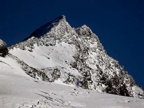
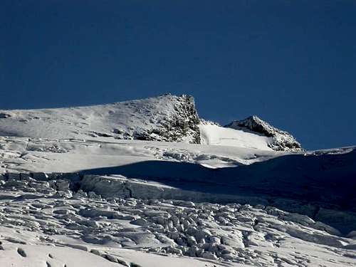
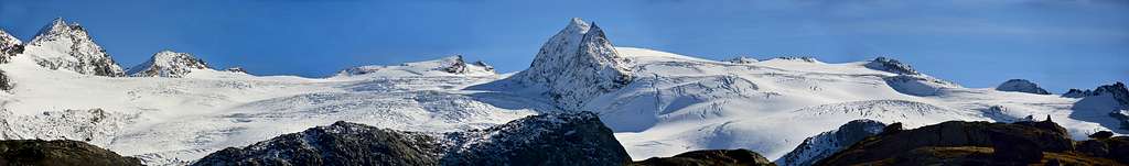
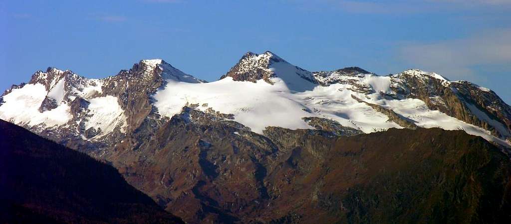
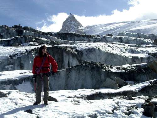
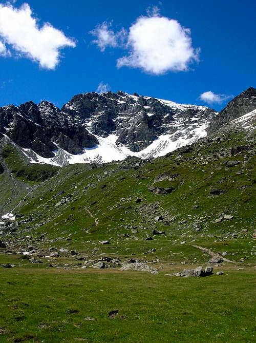
Testa del Rutor (Ruitor) 3486 m is the highest summit belonging to a huge and icy castlelike mountain between the Massiccio del Monte Bianco and the Alpi Graie on the watershed that divides the Valgrisenche from the Valley of La Thuile. 90% of this mountains are situated east of the main ridge between France and Italy. The Rutor is a high mountain but not very showy, in fact it rises slightly from the southern edge of the homonymous glacier. The Rutor glacier is one of the largest glaciers in the Valle d'Aosta and in the whole Italy. It is located in the valley of La Thuile and takes its name from the Testa del Rutor, the highest mountain that surrounds it. It is also surrounded by the peaks of Flambeau 3.315 m, Mount Doravidi 3.439 m, Mount Château Blanc 3.408 m, Becca du Lac 3.402 m and the Grand Assaly 3.177 m. In the middle of the glacier the Vedette del Rutor rise up. The Ghiacciaio del Rutor is no typical alpine glacier, it resembles instead the scandinavian "Inlandeis".
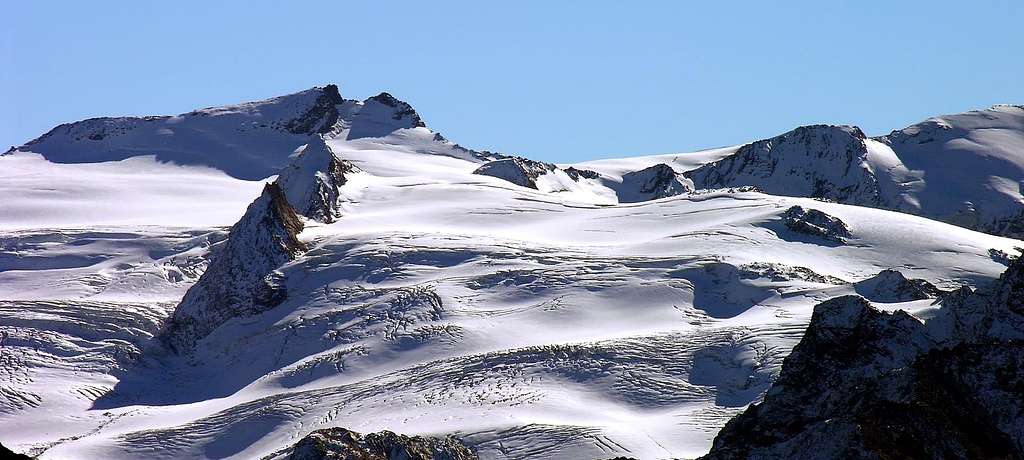
The easiest and most commonly climbed route starts from the hamlet of Les Joux, near la Thuile. The route takes place across the Refuge Alberto Deffeyes Refuge where it is advisable to stay overnight to divide the long ascent in two days. The route is technically easy but rather long, involving a crossing of a glacier. Full glacier gear is required. Another Normal route, the itinerary followed by the first summiters, starts from the side of the Valgrisanche.
La Testa del Rutor (Ruitor) 3486 m è la vetta più alta di un castello di vette situate tra il Massiccio del Monte Bianco e le Alpi Graie sullo spartiacque che divide la Valgrisenche dalla Valle di La Thuile. Il 90% di queste montagne si trova ad est della dorsale principale tra Francia e Italia. Il Rutor è un'a montagna alta ma non molto appariscente, infatti si innalza leggermente dal margine meridionale dell'omonimo ghiacciaio. Il ghiacciaio del Rutor è uno dei più grandi ghiacciai della Valle d'Aosta e dell'intera Italia. Si trova nella valle di La Thuile e prende il nome dalla Testa del Rutor, la montagna più alta tra quelle che lo circondano. Il Ghiacciaio del Rutor è infatti circondato anche dal Flambeau 3.315 m, dal Monte Doravidi 3.439 m, dallo Château Blanc 3.408 m, dalla Becca du Lac 3.402, dal Grand Assaly 3.177 m. Nel mezzo del ghiacciaio sorgono le Vedette del Rutor. Il Ghiacciaio del Rutor non è un tipico ghiacciaio alpino, assomiglia invece allo scandinavo "Inlandeis".
Il percorso più facile e più frequentato inizia dalla frazione di Les Joux, vicino a La Thuile. Il percorso si svolge attraverso il Rifugio Alberto Deffeyes, dove è consigliabile pernottare per dividere in due parti la lunga salita. Il percorso è tecnicamente facile ma piuttosto lungo ed implica l'attraversamento di un ghiacciaio. È perciò necessario l'equipaggiamento completo per il ghiacciaio. Un' altra via Normale, che è l'itinerario seguito dai primi salitori, inizia dal versante della Valgrisanche.
First ascents
- First on the Summit: Gottlieb Studer, G.G. Weilenmann and Bucher with Valgrisenche Mountain Guide Giovan Battista Frassy; Aug 16th, 1858, in ascent by mixed route on Southeast Face and South Crest from Valgrisenche Commune, through Arp Vallon, Eastern Morion Glacier and Col du Morion.
- In winter: Unknown. There is a winter crossing from Planaval Pass, Flambeau, Doravidi but stops at the Château Blanc by D. Arnod, G. De Tommasi, Pierino Creux, P. Brunodet and René Willien; February 26th, 1940, in ascent from La Thuile.
- East Gully: Osvaldo Cardellina, Marco Cossard, Franco Lenzi and Roberto Ravenna; Aug 12th, 1973, in ascent in day from Bonne through Morion Glacier.
- South Crest (Morion to San Grato Passes): Abbé Aimé Gorret with Mountain Guide Valgrisenche Giovan Battista Frassy; Jul 21th, 1868, ascent by Valgrisenche.
- South Crest (direct to Top): Giovanni Bobba, Luigi Cibrario, Luigi Vaccarone with Mountain Carrier G. Noro; Aug 19th, 1890, in ascent from "Forcella del Rutor".
- South ridge (from Forclaz du Bré): Osvaldo Cardellina, lone; Aug 17th, 1977, in ascent in day from Bonne Arp small Valley.
- Southwest Wall: Osvaldo Cardellina, solo; Aug 15th, 1977, in ascent in day from Bonne San Grato Vallon.
- West Crest: Osvaldo Cardellina, Giuseppe Lamazzi, Sergio Roverso and Nino Trapani; Jun 30th, 1974, in ascent in day from La Joux.
- Northwestern Face: Unknown.
- North-northeast Ridge: W. Mathews and T.G. Bonney with Mountain Guide Chamonix Michel Croz; Sep 1862, in ascent from La Thuile through Rutor Pass
- Great traverse (from Baulen or Baulìn Village through Planaval Pass to Testa del Rutor, round trip) : Osvaldo Cardellina, Christian Cardellina, Marco Cossard and Giuseppe Lamazzi; Aug 07th, 1983, in day with ascent from Baulen Village through complete crossing on Flambeau, Doravidi Hill, Doravidi North and South, Château Blanc Pass and North, South Summits, Rutor Pass towards Testa del Rutor or Ruitor with return at the base of Morion Château Blanc Glaciers.
Getting There
Getting to Aosta
- from Italy: Milano - Novara - Ivrea - Pont-Saint-Martin - Saint Vincent - Aosta
or: Torino - Ivrea - Aosta (Highway A5)
- from Switzerland: Bern - Montreux - Martigny - Colle del Gran San Bernardo - Aosta
or: Sion - Martigny - Col du Grand Saint Bernard - Aosta
or: Bellinzona - Lugano - Como - Milano (only direction) - Novara - Aosta
- from France (also Genève): Tunnel del Monte Bianco (toll) - Courmayeur - Aosta
or (less expensive but a little longer, if you come from Genève take the tunnel): Colle del Piccolo San Bernardo - La Thuile
- from Austria: Brennero - Trento - Verona (only direction) - Brescia - Bergamo - Milano - Aosta
Getting to La Thuile (Northern Normal route)
Once you reach Aosta, continue to Pré St. Didier, where you take the road to the Colle del Piccolo San Bernardo up to La Thuile 1441 m. From the middle of the village, before the bridge over the Dora, turn to right and pass a parking lot. Follow the road to the hamlet of La Joux 1650 where the road ends. Leave the car in the parking lot.
Getting to Bonne in Valgrisenche (Southern Normal route)
From the Aosta Ovest motorway exit, turn left onto the SS26 towards Courmayeur Mont Blanc. The junction to the Valgrisenche is on a well-signposted roundabout. The roundabout signpost indicates Leverogne - Valgrisenche. The Valgrisenche is the westernmost of all important valleys south of the main valley (Valle d'Aosta) between Aosta and Pré-Saint-Dider. Arvier is the small village situated at the entrance of the valley. Enter the Valgrisenche and drive until you arrive in Bonne 1810 m. Beyond Bonne (right in front of the Beauregard dam), a road closed to ordinary traffic comes off to the right (signs with poles). It is possible to park the car just beyond the start of the dirt road on the right.
Accesso a La Thuile (Via Normale Nord)
Giunti ad Aosta si prosegue per Pré St. Didier, dove si prende la strada per il Colle del Piccolo San Bernardo fino a La Thuile 1441 m. Dal centro del paese, prima del ponte sulla Dora, girare a destra e superare un parcheggio. Seguire la strada fino alla frazione La Joux 1650 dove la strada finisce. Lascia l'auto nel parcheggio.
Accesso a Bonne in Valgrisenche (Via Normale Sud)
Dall'uscita autostradale di Aosta Ovest svoltare a sinistra sulla SS26 in direzione Courmayeur Mont Blanc. Il bivio per la Valgrisenche si trova su una rotonda ben segnalata. Il cartello della rotonda indica Leverogne - Valgrisenche. La Valgrisenche è la più occidentale di tutte le valli importanti a sud della valle principale (Valle d'Aosta) tra Aosta e Pré-Saint-Dider. Arvier è il paesino situato all'imbocco della valle. Entrare nella Valgrisenche e proseguire fino ad arrivare a Bonne 1810 m. Oltre Bonne (proprio di fronte alla diga di Beauregard) si stacca a destra una strada chiusa al traffico ordinario (cartelli con paline). E' possibile parcheggiare l'auto poco oltre l'inizio della strada sterrata sulla destra.
Testa del Rutor Normal route from the Refuge Alberto Deffeyes
Summit altitude: m 3486
Difficulty: Alpine F
Difference in level: 845 m to the hut, 1000 m from the hut to the summit
Exposure: North
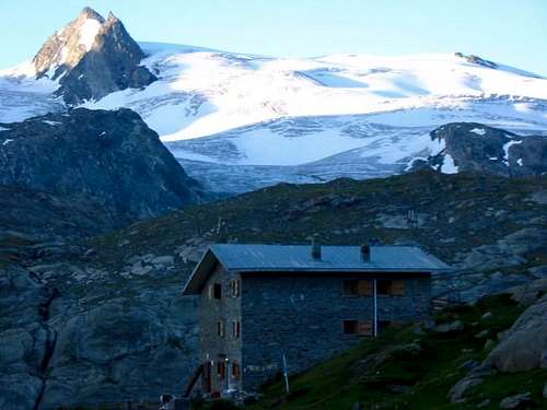
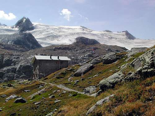
Hut: Rifugio Alberto Deffeyes m 1920
Starting point: La Joux 1650 m, La Thuile
An interesting long ascent with low technical difficulty
Approach to the Rifugio Deffeyes
From La Joux you reach the hut in about 3 hours by walk following the triangular signpost of the Alta Via n. 2. Leaving the village of La Joux take the easy path that - after a level start - soon starts to climb up hairpin bends in the wood. The path runs along the stream fed by the Rutor glacier and other glaciers in the area. The water stream forms three famous waterfalls that you can admire following the short branches that come off the main path. The itinerary passes near the ruins of the Montagne du Glacier and rises along the last stretch allowing to gain altitude and reach the hut.
Second day
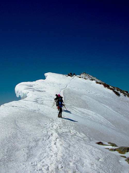
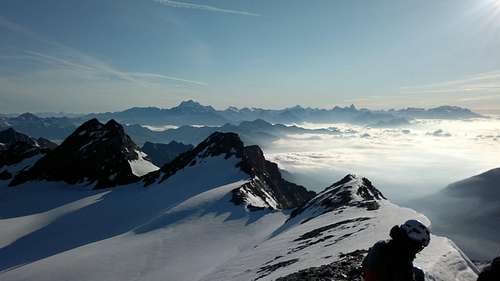
From the refuge, follow the path that descends slightly to cross a small stream. Crossing an area with some ponds, the path becomes less evident, but it is however indicated by the little men. Going around a hump it passes at the foot of the rocks below the Pointe des Invergneures, in view of the glacier. Follow the moraine and at its end you pass a rocky passage facilitated by a metal chain, reaching the mouth of the valley that goes up to the Planaval Pass. Leave the main path and continue to the right towards the Rutor Glacier. Go up it in a southerly direction, skirting at the base the ridge formed by the Flambeau, the Doravids and the Château Blanc, a route that allows you to avoid the crevasses in the middle of the glacier and reaching the Colle del Rutor 3373 m. From the pass, follow the wide ridge with rocky stretches sometimes snowy, until it touches the easy final rocks and the trigonometric point of the Military Geographic Institute with a statue of the Madonna. However, the highest point is a few meters ahead, and can be reached by passing a short stretch of simple climbing.
Descent: along the ascent route.
Avvicinamento al Rifugio Deffeyes
Da La Joux si raggiunge il rifugio in circa 3 ore a piedi seguendo i cartelli triangolari dell'Alta Via n. 2. Uscendo dal villaggio di La Joux, si prende una strada che, dopo un inizio pianeggiante, prende a salire a tornanti nel bosco. Il percorso corre lungo il torrente alimentato dal ghiacciaio del Rutor e da altri ghiacciai della zona. Il flusso d'acqua forma tre famose cascate che si possono ammirare seguendo le brevi diramazioni che si staccano dal sentiero principale. L'itinerario passa vicino alle rovine della Montagne du Glacier e sale lungo l'ultimo tratto permettendo di guadagnare quota e raggiungere il rifugio.
Secondo giorno
Dal rifugio si segue il sentiero che scende leggermente per attraversare un torrentello. Attraversata una zona con alcuni laghetti, il sentiero diventa meno evidente, ma è comunque segnalato da ometti. Aggirato un dosso transita ai piedi delle rocce sotto la Pointe des Invergneures, in vista del ghiacciaio. Si segue la morena e al suo termine si supera un passaggio roccioso agevolato da una catena metallica, raggiungendo lo sbocco della valletta che sale al Passo di Planaval. Si lascia il sentiero principale e si prosegue verso destra in direzione del Ghiacciaio del Rutor. Lo si risale in direzione sud, costeggiando alla base la dorsale formata dal Flambeau, dai Doravidi e dallo Château Blanc, percorso che consente di evitare i crepacci al centro del ghiacciaio e raggiungendo il Colle del Rutor 3373 m. Dal valico, si segue la larga dorsale a tratti rocciosa a tratti nevosa, fino a toccare le rocce terminali che si salgono facilmente fino al segnala trigonometrico dell'IGM e alla Madonna. Il punto culminante dista pochi metri e può essere raggiunto con un breve tratto di facile arrampicata.
Discesa: lungo l’itinerario di salita.
Testa del Rutor Normal route from Valgrisenche
Summit altitude: m 3486
Difficulty: Alpine F+
Difference in level: 1106 m to the hut, 550 m from the hut to the summit
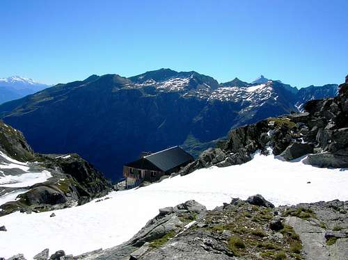
Hut: Rifugio degli Angeli m 2912
Starting point: Bonne 1810 m
An interesting long ascent with low technical difficulty
Approach to the Rifugio degli Angeli
From the parking lot take a dirt road entering the valley, well signposted with a yellow stamp and the number 16. The road is cut by several shortcut paths and it rises to Arp Vieille 2220 m. On your left you will see the Capitan Crova shelter and just beyond the lakes of the pasture. From here it is necessary to continue on the right side of the valley and to skirt it, then take an obvious path at the end of the lake that rises with hairpin bends on the right slope, at first gently then steeper up to the refuge.
Second day
Just before reaching the refuge - if you stay overnight at the refuge, you must therefore go back - the track to the summit of the Rutor jumps off to the left. Proceed with a long cross to the right along easy slopes to the Ghiacciaio Orientale del Morion. Go past some easy rocks and set foot on the glacier. Another traverse will take us to a more steep stretch and overcoming a gully will lead to the base of the slope dominated by the Colle del Rutor. When you reach the Colle del Rutor 3376 m turn left, on an easy ridge of rocks and you go to the summit. You will find the trigonometric point of the Military Geographic Institute and a statue of the Madonna. However, the highest point is a few meters ahead, and can be reached by passing a short stretch of simple climbing.
Avvicinamento al Rifugio degli Angeli
Dal parcheggio prendere una strada sterrata che entra nella valle, ben segnalata con un segnale giallo e il numero 16. l percorso può abbreviato da numerose scorciatoie e sale a raggiungere l'alpeggio Arp Vieille 2220 m. Sulla sinistra appare il rifugio Capitan Crova e appena oltre i laghi del pascolo. Da qui è necessario proseguire sul lato destro della valle e costeggiarla, quindi imboccare un evidente sentiero che al termine del lago sale a tornanti sul versante destro, dapprima dolcemente poi più ripido fino al rifugio.
Secondo giorno
La traccia di salita al Rutor ha inizio poco prima di raggiungere il rifugio - se si pernotta al rifugio occorre quindi tornare un pò indietro - e sale a sinistra. Proseguire con una lunga traversata verso destra lungo facili pendii in direzione del Ghiacciaio Orientale del Morion. Superare alcune rocce facili e mettere piede sul ghiacciaio. Un'altra traversata conduce ad un tratto più ripido e superando un canale si giunge alla base del pendio dominato dal Colle del Rutor. Raggiunto il Colle del Rutor 3376 m si tiene la sinistra su un facile crestone di rocce che conduce in vetta. Troverete il punto trigonometrico dell'Istituto Geografico Militare e una statua della Madonna. Tuttavia, il punto più alto è pochi metri più avanti e può essere raggiunto con un breve tratto di semplice arrampicata.
Red Tape
No permits are required, there are no fees at all and the trailhead-parking in la Joux or Bonne is for free. The mountain stands outside the Parco Nazionale del Gran Paradiso, so the rules for wildlife and conservation are not so strict, but in the end that should not make any difference! The Rifugio Deffeyes is open only in summer and on spring weekends on request. The hut also has a winter-section with 18 places.
Non sono richiesti permessi, non ci sono tasse e il parcheggio a La Joux e Bonne è gratuito. La montagna si trova fuori dal Parco Nazionale del Gran Paradiso, quindi le regole per la fauna e la conservazione non sono così rigide, ma alla fine non dovrebbe fare alcuna differenza! Il Rifugio Deffeyes è aperto solo in estate da giugno a settembre e nei fine settimana di primavera su richiesta. La capanna ha anche locale invernale con 18 posti.
 |
 |
 |
 |
 |
When To Climb
Best time to climb the mountain is from mid June to mid September.
Ski ascents in spring (April/May) have to be awesome!
Ascents in Winter are longer and harder but absolutely possible and technically easy.
Il periodo migliore per salire la montagna va da metà giugno a metà settembre.
Le ascensioni con gli sci in primavera (aprile/maggio) devono essere fantastiche!
Le salite in inverno sono più lunghe e difficili ma assolutamente possibili e tecnicamente facili.
Huts
Rifugio Deffeyes +39/165/884239
Rifugio degli Angeli 2912 m (ex Rifugio Scavarda al Lago Morion)
- The Rifugio degli Angeli stands on the site of the former Rifugio Scavarda. The old structure has been completely renovated by a group of volunteers who now manage the shelter; all the profit from the management go to charity to finance projects in Mato Grosso in Brazil.
Refuge du Ruitor (2022 m/french side, extremely long ascent, not recommended)
Opens on reservation
0479069212
Camping and other accomodation
Camping on the mountain is allowed.
Camping Rutor
La Thuile (Frazione Villaret)
+39/165/884165
Hotels of every category except for luxury in La Thuile
 |
 |
 |
 |
 |
Mountain Conditions
weather conditions: Bollettino meteorologico VdA
weather conditions: tempoitalia.it
Regione Valle d'Aosta
 |
 |
 |
 |
 |
Lords of the castle
The main summits of the Rutor group
Testa del Rutor (3486 m) Italy
Doravidi (3439 m) Italy
Becca du Lac (3396 m) France/Italy
Vedette (3332 m) Italy
Mont Paramont (3300 m) Italy
Gran Becca du Mont (3214 m) France/Italy
Grande Assaly (3174 m) France/Italy
 |
 |
 |
 |
 |