
-
 30199 Hits
-
 85.87% Score
-
 21 Votes
|
|
Area/Range |
|---|---|
|
|
46.95220°N / 13.92840°E |
|
|
8008 ft / 2441 m |
|
|
Overview
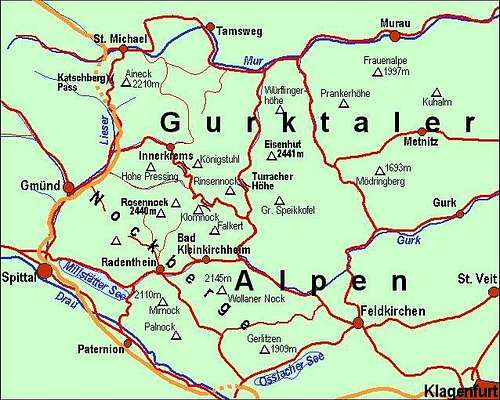 A self-made map of Gurktal Alps / Nockberge
What's New On This Page?
- April 7th, 2013: SP V3 design updated.
- Jan 27th, 2013: New pictures embedded.
- Feb 18th, 2006: Link to new pages inserted: Rosennock, Klomnock, Rinsennock.
- Oct 31st, 2004: Link to a characteristic picture inserted.
- Oct 17th, 2004: Initial set up of the page.
The Purpose of This Page
On this page I would like to give an overview information of Gurktal Alps / Nockberge in order not to be repeated on all distinct summit pages. Regarding pictures and routes, this page is the place only for overall information.
About Gurktal Alps
Gurktal Alps lie between Hohe Tauern on the west and Lavanttal Alps on the east (beyond the Gurk and Olsa valley) and between Mur river valley on the north and Drau/Drava valley on the south. The whole area stretches some 72 km in the west-east direstion and some 54 km in the north-south direction; so it measures around 3300 square kilometers. The main crest of this mountain group goes more on its northern part. Katchberg pass, which divides the group from Hohe Tauern lies far on the north. From there the main crest line goes towards SE on Turracher Hoehe pass and again towards NE and further towards E to Perchauer Sattel (saddle), which again lies extremely on the northern part, just above the Mur river. So only a minority of waters flows towards north into Mur, and the majority flows towards south, into Gurk and Drau.
Geology and the look
Geology
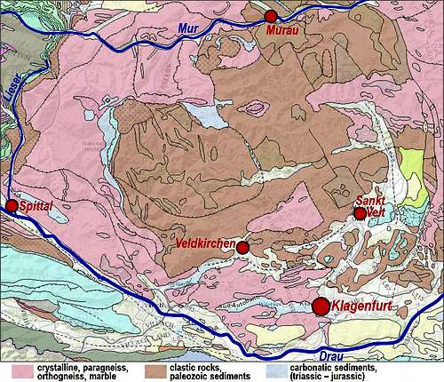
 Why are Nockberge always so dry?
The map on the left illustrates the quite simple geological structure of Gurktal Alps. The pink areas denote the old metamorphic basement of Austroalpine, a geological formation of the Eastern Alps. Various paleozoic rocks were in millions of years transformed by pressure and temperature. Also the brown part of Gurktal Alps is very old by origin. Those are various paleozoic rocks, which were in millions of years fragmented, decomposed and piled to various levels of thickness. Only near the central part of Nockberge (NE of Rosennock and NE of Turracher Hoehe) some younger (mezzozoic) carbonatic rocks can be found (blue), but only a few mountains have different (lighter look). In the valleys and basins (especially on the south) the white areas are alluvial morraines and river debris or parts of molasse. Some blue areas near the town of Spittal, Veldkirchen and Klagenfurt are of course lakes (and not rock types).
The look
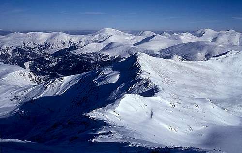 Mathias Zehring - The characteristic 'hilly' landscape of Nockberge, seen from the summit of Hohe Pressing
East of the majestic Hohe Tauern group chains of central Alps lower considerably. North of Mur the Niedere Tauern are still exhibiting a high alpine character, while between rivers Drau on the south and Mur on the north, mountains are more hilly, reaching at most altitudes around 2400 meters, which for gneiss mountains means rounded tops, no vertical rock walls and only moderately steep grassy slopes.
The Name
In literature this broad mountain group is differently named. Its most interesting western part is named Nockberge, because names of many summits end on -nock, for example: Rosennock, Peitlernock, Klomnock, Mirnock, Palnock etc. But towards east this sub-area stretches more or less only to Gurk river and Turracher Hoehe pass. Further towards east summits are lower and less attractive for mountaineering. But the whole broad area, its western, 'Nock' part and eastern part is often referred also as Gurktaller Alpen (in German). Actually the Gurk river is a central figure in these mountains, although it is not a big one.
Rivers
Now listen to the names of both bordering rivers: Mur and Drau. How do they sound to you? Yes, Mur is dark, Drau is much lighter. That's also how their colours look like. Mur's source is in Hohe Tauern, under the northern slopes of Hafner. Then it flows between mountain chains, formed of old rock structures, so it keeps its dark colour way down into the Panonia plane. On the other hand, Drau has its source in Sexten Dolomites and then forms the border between Central Alps (Hohe Tauern) and South Limestone Alps (Lienz Dolomites, Karavanke), which enables it to keep some of its light colour. And there is, of course, the third river - Gurk. Its sources are in the middle of the group, below Turracher Hoehe pass, which lies on the main mountain ridge. At first Gurk is flowing towards south and south-east and when one would expect it flowing the rest of the short distance to Drau near Klagenfurt/Celovec, Gurk suddenly decides to enjoy a bit more independence. It turns left and flows far towards north-east, and only there, between Friesach and Althofen, receiving from north waters of Olsa, it turns towards south again and finally reaches Drau east of Klagenfurt/Celovec. For outdoor activities these three rivers are not the best suited. Mur and Gurk are still small, while Drau's river bed is artificially modified because of many power plants. Still nature around these rivers and many Kaernten lakes (artificial and natural) is very nice, suitable for hiking, cycling, fishing and surfing.
People
People, inhabiting the area are mostly Austrians. But also Slovenian minority in Kaernten should be mentioned. Its status has improved with the unified Europe and we should only hope that this trend continues. Regarding the nationality structure these areas were traditionally mixed in history. Slovenian people were living far towards north (Diex/Djekse on Saualpen, on both sides of Drau/Drava river (and Gail/Zila river more towards west) and German speaking people were living far more towards south (Maribor, Kocevje) than nowadays. I am mentioning this only for us to be aware of that and tolerant. And this is also the reason why I write some names in both languages, German and Slovenian.
Subgroups and Summits
Any division of Gurktal Alps / Nockberge into smaller subgroups would be quite artificial. Valleys and passes are dividing distinct mountains and until this group attracts more attention, it would be best to leave it in one piece. On the above map of the area you can see how the altitudes of summits are decreasing in the west-east and north-south direction. Some main summits are named on the above map.
Places of Interest
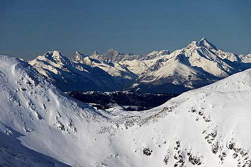 Nice view from Nockberge on higher mountains towards the NW - Niedere Tauern and Dachstein
From the mountaineering standpoint Gurktal Alps are nice only for hiking and tour skiing. They offer nice views in all directions, in a clear day mountain groups in all four directions can be clearly seen. Due to their character, high passes, alpine meadows and even some summits can be also reached by a mountain bike, many ordinary roads and cart-roads offer almost an infinite number of biking combinations. The same holds for tour skiing. Rounded summits offer downhills in almost all directions, only exceptionally in hard winter and when ridges are icy, some tours will require special winter equipment. Because the group is lying in the middle of Eastern Alps, weather disturbances have a lesser impact on them, so often other regions get more snow falls than Gurktal Alps. Still many areas are well developed also as ordinary ski resorts. The most known ordinary ski resorts are: St. Oswald and Bad Kleinkirchheim (Wollaner Nock), Gerlitzen, Innerkrems, Katschberg (Aineck), Turracher Hoehe (Rinsennock), Flattnitz and others. There you can use cable-cars to bring you high on mountains and from there you can continue on many ski tours. Along Drau and Mur valley very frequented long-distance cycling routes go. They are well marked, mostly go on special roads and offer also other infrastructure. Many other cycling routes are signed also on other side-roads. Mountain biking was already mentioned.
Getting There
 Murau
MurauFor the broader orientation see the Eastern Alps GROUP page! From the highway Salzburg - Villach you can exit in St. Michael, Gmuend, Spittal, Paternion and Villach. From south, from Italy, Villach can be reached by the highway from Udine via Tarvisio. Villach and Klagenfurt are also connected by a highway. Along the Mur river there is no highway between St. Michael and Judenburg, but the road is good. Through Mur valley, Drau valley, Lavant valley and Gurk/Olsa valley also railways go. On the web, you can see a detailed map on: http://www.austrianmap.at/.
One bike & hike proposal: Nockalmstrasse.
Allow me here to propose a great cycling tour which will guide you through a beautiful part of Nockberge and from which you will also take two typical summits. A. General: From 611m to 2331m. Good asphalt roads, easy marked mountain paths. Max steepness of the road is 12%. Gear: good bike (any kind: travel, mountain...), any shoes (in good weather), a tent and sleeping bag. B. Effort: 100km biking - 2100m of altitude, 400m (hiking), some 13h-14h net time. Route description: Millstatt (611m) - /13km/ - Radenthein (746m) - /8km/ - Bad Kleinkirchheim (1100m) - /5km/ - Patergassen (1030m) - /4km/ - Ebene Reichenau (1062m) - /13km/ - Schiestlscharte (2024m) - /45min walk-up/ - Klomnock (2331m) - /30min descent/ - Schiestlscharte (2024m) - /8km/ - Sackl Huette by Leoben Bach (1500m) - /6km/ - Highest road point (2042m) - /20min walk-up/ - Eisentalhoehe (2180m) - /15min descent/ - Highest road point (2042m) - /6km/ - Innerkrems (1480m) - /10km/ - Kremsbruecke (952m) - /10km/ - Gmuend (735m) - /12km/ - Seeboden (611m) - /5km/ - Millstatt (611m).
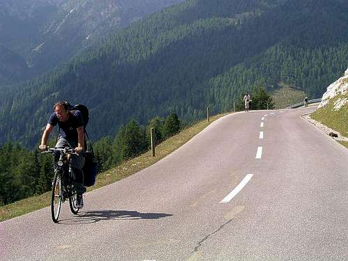
From Millstatt you bike partly by a biking road, partly by a frequented motor road to Radenthein, where you start a quite unpleasant ascent to Bad Kleinkirhheim. Mostly you do it by a motor road, a special biking road is only at the beginning. At the end of this famous resort you cross the saddle and descend into the Gurk valley. Reaching it you turn left and drive comfortably past Ebene Reichenau. Soon after the town the famous Nockalmstrasse deters left. There's no fee for bikers (righteously!). An up to 12% steep road brings you almost 1000m higher, the recommended sleeping point can be on Schiestelsattel. But before having the deserved rest it's good to ascend also the highest mountain in this area - Klomnock. If you have a tent (as we did), a good (hidden) place is just above the saddle, on the southern side. Next day a 500m descent awaits for you first. After reaching the lowest point in Leoben Bach valley you turn right (sign: Innerkrems) and start ascending again. More than 540m of altitude, and the road of a similar steepness as yesterday brings you on the highest point of the Nockalmstrasse. It's fine to stretch legs and hike-up the neighbouring summit of Eisentalernock. Now the fun begins! By a good road you drive all the way down to Innerkrems, further (left) to Kremsbruecke and (left again) by the valley of Lieser to Gmuend. This beautiful city is worth visiting and you also deserve a beer or coffe. After Gmuend you continue by the valley of Lieser, then on the main crossroads turn left again towards Milstaetter See and reach Seeboden. Then by the crowdy northern coast of the lake to the point where your car is waiting for you.
Red Tape
 Windebensee
 In the parc
In the whole area there are no major restrictions. Highways in Austria need to be paid, toll needs to be paid also for the Nockalm panoramic road. Other major mountain passes are toll free. A great portion of Nockberge is a natural parc. For more details, see the official web site of Nationalpark Nockberge.
When To Climb
 Spring in Nockberge
 Strong winter winds
You can climbGurktal Alps in any season. For weather conditions for Austria see here (then choose regions: Steiermark and Kaernten). Avalanche info pages are the following: For Steiermark, For Kaernten.
Camping
In the group there are many mountain huts, too many to name them all here. They will be described at every summit page. Among towns around Gurktal Alps I have found some with web pages: Tamsweg, Murau, Althofen, Klagenfurt, St. Veit, Feldkirchen, Villach, Spittal, Gmuend, Bad Kleinkirchheim, Innerkrems.